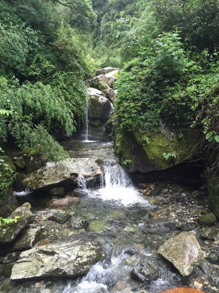
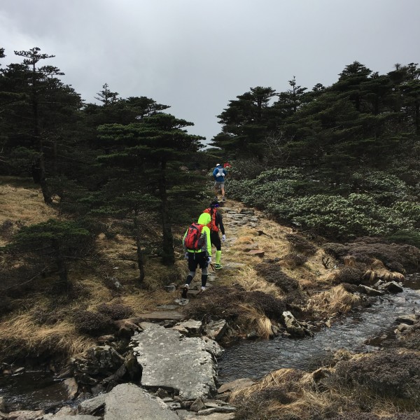
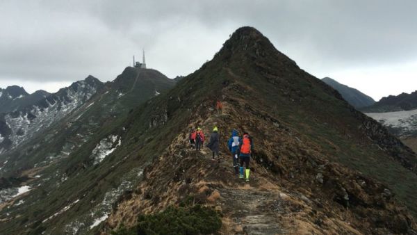
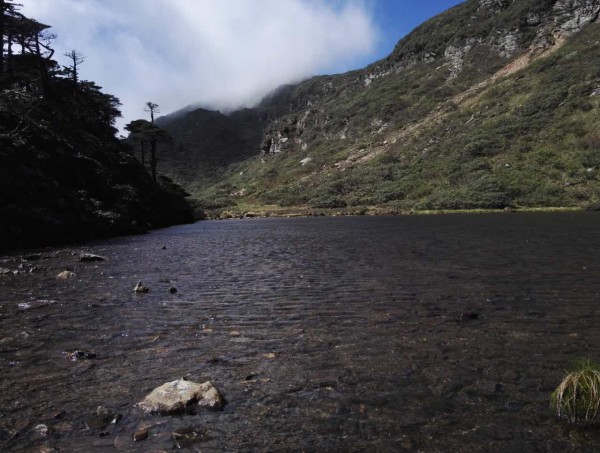
Cangshan Mountain in Dali has various geological and geomorphological features such as glacier landform, fault peak cluster, Cangshan Waterfall, Cangshan metamorphic rock, marble geology, wrinkled mountain landform, etc. The forest at the foot of the mountain is verdant, with waterfalls, clear springs and Longtan Huaxi in ten steps and one scene. At the peak of the mountain, the sea of clouds billows in summer and the azalea is brilliant. In winter, the snow is covered with snow and the beauty is very hard to express.
As the south side is adjacent to the Ximatan cableway station and there are mature hiking trails connecting the Cangshan jade belt tour road, the trail directly down to yinqiao town in the north side is also easy to identify and is favored by outdoor mountaineers.
One. The roue of taking the three-peak to the south.
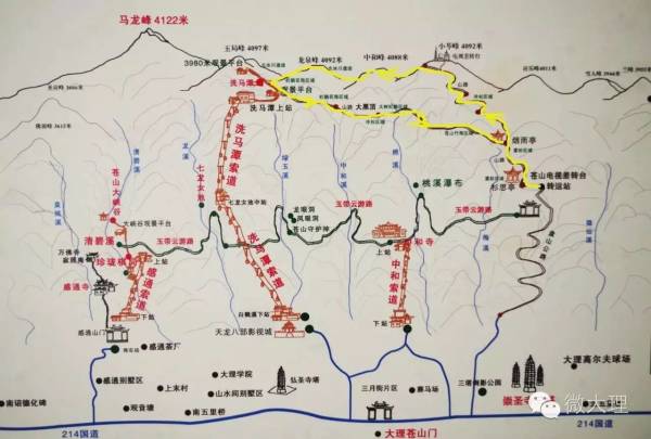
From the ancient town to the 3200 platform above sea level (i.e. Cangshan TV turntable transfer station), there is winding mountain highway, which can be used to drive off-road vehicles and minibuses to save a lot of physical strength. Then 3200-Yanyu Pavilion-Xiaocen peak, the earth-rock trail goes straight up, which takes a lot of physical energy. It takes about 4 hours to climb from an altitude of about 3200 meters to over 4000 meters. If there is a team organization, you can camp in the poor turntable, with electricity and water.
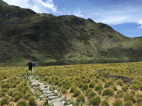
There is only one road along the ridge from the Chazhuantai to the south to Shimatang. It takes 1 hour to take photos while walking, and the altitude of Ximatan is 3950 meters. Ximatan-Cangshan Nature Education Center-Daiheiding-Yanyu pavilion-3200, with earth-rock hiking trails through virgin forests, streams and mountain streams, fir and bamboo forests; Due to the luxuriant trees, some sections of the road may get lost, so experienced people are needed to lead the way, and the whole journey takes about 3 hours for 7 kilometers.
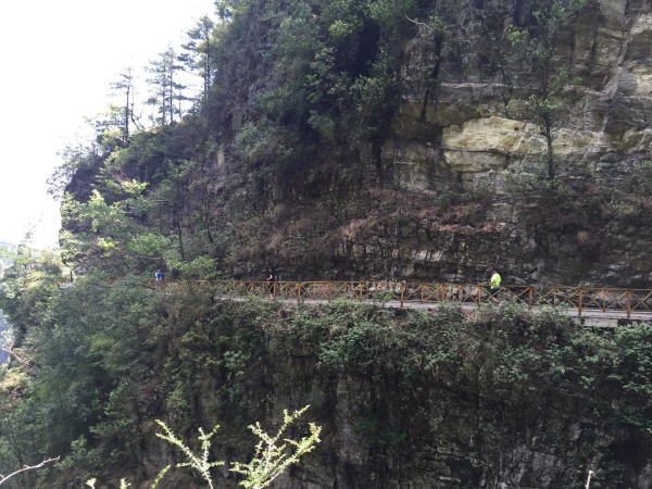
Now the cableway has been repaired to Ximatan. The most convenient way is to take the cableway to Ximatan and then climb the mountain. However, crossing the plank road of ximatan scenic area to enter the “unopened sightseeing area” will be blocked by the staff, because the disappearance of people who rush to mount Cangshan will happen every few months.
From Ximatan go down the mountain, you can choose to go from Yuju Peak to Yudai Road and Dali University directly along the cable tower. This is the nearest one. Because when the cableway was built, a construction and maintenance access road was opened, but some sections of the road passed the cliff.
From Ximatan go down the mountain, you can also go straight down to Zhonghe Temple from the Daheiding. The scenery in late autumn is very beautiful.
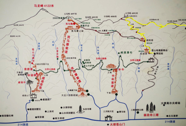
Two. The roue of taking the three-peak to the North.
(3800 right to yingle peak lane fork)
We will go climbing the mountain at 7:20,then reached 3800 altitude of Chayingle Peak, and reached Huanglongtan at 4:30 and returned to line 214 under Wahaha waterworks at 7: 20. ,the whole journey lasted nearly 27 kilometers and 12 hours.
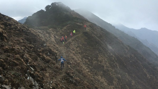
Three.The roue of taking the Five-peak to the North.
Combined with the two lines from above, we go straight to Xiaocen Peak and go north through Xiaocen Peak, Yingle Peak, Yeti Peak, Lanfeng Peak and Sanyang Peak.
Reference time: 6:25 we will go down to Cangshan 3200, 8: 25-10: 30 Xiaocenfeng, 15: 00 p.m. to Huanglongtan, 16:30 to Heilongtan, downhill, 19: 00 at the quarry.
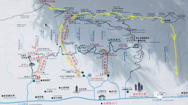
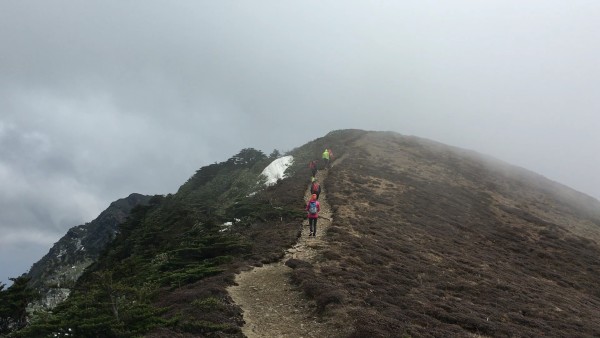
The roue of taking the seven-peak to the North and To climb the main peak
Day1.On the cableway to climb ximatan-Longquan peak-zhonghe peak-xiaoluo peak (TV differential turntable)-yingle peak-yeti peak-lanfeng-sanyang peak-huanglongtan-shuanglongtan
This road is basically walking on the ridge of Cangshan Mountain, with a distance of about 8 kilometers. Starting from Ximatan, we reach the high Dafeng pass at an altitude of 4070m. After crossing the pass, we cut down the slope and move on, then we reach Longquan Peak. Further on, you can see a towering TV tower-Cangshan TV Station, which was once the highest TV tower in the country and was located at the summit of Xiaocen with an altitude of 4092 meters. Ridge such as tough, exposure is very strong, strong winds blow, hikers have to use hands to help to walk, winter and spring season is biting cold. The camping that night was in the quiet and beautiful Shuanglongtan.
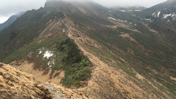
Day2. Shuanglongtan-Heilongtan-Bamboo Forest-Mountain Path-Qianshuichi Factory-Yinqiao Town
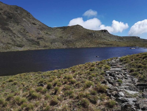
All the way down, through Shuanglongtan and Heilongtan, through a bamboo forest and then along a mountain path to Qianshuichi Factory, down 1648 steps, to the end of Yinqiao Town, a distance of 9 kilometers. The black dragon pool, the double dragon pool and the yellow dragon pool are all hidden in the big bosom of sanyang peak. therefore, sanyang peak has become the most beautiful place for Cangshan mountain. However, the altitude of the sea wave here is over 3900 meters, so it is not bad to go down the mountain. It would be much more difficult to go up the mountain road in reverse.
There are many extend ways to this route:
1. It is also possible to cross from north to south: Yinqiao Town-Qianshuichi Factory-Mountain Path-Bamboo Forest-Heilongtan-Shuanglongtan-Huanglongtan-Sanyang Peak-Lanfeng-Yeti Peak-Yinglefeng-Xiaoluo Peak (TV Turntable)-Zhonghe Peak-Longquan Peak-Shimantan cableway station. However, to enter the mountain from Lingquan Creek in Yinqiao Town, you must first climb 1648 steps to Qianshuichi Factory, then enter the deep forest and climb along the rugged mountain path, which requires much physical strength, endurance and perseverance.
2. If you have enough time and physical strength, you can start from Tianlong Babu Film and Television City, and walk along the pylon of the Shimantan cableway to Shimantan, a distance of about 6 kilometers. It can also be Wuwei Temple: Wuwei Temple-Ge Laoya-Old Mining Factory-Mountain Path, with the same route behind; It became a three-day route.
3. After arriving at Xiao ‘ao Peak (TV station), there is another mountain road to choose from: Xiao ‘ao Peak-3200m Alpine Post Station-Panshan Highway-Santai-Dali Ancient City.
4. If organized by the outdoor association, you can camp in Ximatan. The next morning, you can go straight to the highest mountain in Cangshan, Malong Peak (4122 meters above sea level), for about 3 hours and pass through Yuju Peak. On the return trip, you can go down to Gantong Temple directly along Qingbi Stream. This road is difficult to walk through several waterfalls and cliffs.
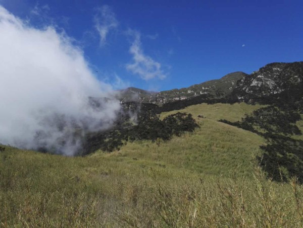
The best time to climb Cangshan is from March to May and from October to November each year when the weather is clear. June to August is when all kinds of azaleas are in full bloom in Cangshan, but there is more rain, which is not conducive to camping on the mountain.
Cangshan’s climate is changeable in summer and autumn. It is very changeable. It is sunny at the foot of the mountain. The mountain may be foggy, hail and snowy. There is 20 cm thick snow on the mountain top, which cannot be seen on the mountain foot. At night, the temperature is very low, so you should bring more warm clothing, and at the same time prepare lighting appliances, preferably rechargeable LED lights, communication tools are essential, and medicine preparation points for preventing and treating trauma. And hiking shoes must be awesome. In addition, raincoats are essential.
Cangshan longitudinal route is located in a high altitude area, with an average altitude of 3500-4000 meters and a maximum altitude of 4122 meters. hikers are ready to cope with altitude reaction.
Because of the changeable climate, it is very risky for inexperienced people to enter the unopened tourist area and climb Cangshan Mountain. Friends who go for the first time suggest organizing a group and looking for a professional guide to recommend Dali Deep Outdoor Sports Club. Tel.: 0872-2122787, 2183809, 8811226.
Tips for outdoor adventure camping equipment:
1. Personal equipment: backpacks (with rain cover), tents, moisture-proof pads, sleeping bags (comfortable -10 degrees), assault clothing, assault pants, down jacket, hiking shoes, thermal underwear, fleece-catching clothing, fleece-catching pants, spare socks, quick-drying clothing, headlights, rain gear, hiking sticks, sunglasses, personal special drugs, water bottles, chopsticks (or spoons), personal daily necessities, sunscreen, cameras (with batteries), cell phones (with batteries), compression bags, waterproof bags, garbage bags, hats, gloves, headlights, thermos pots, stoves, pots, etc. Realgar is used to prevent poisonous snakes when preparing for camping.
2. Recharge: Heat loss is rapid in plateau areas. For carrying heavy loads, you need to bring your own high-calorie food to supplement your physical strength. Chocolate, compressed biscuits and vitamins can be properly prepared.
see more about biking tour
Seeing Dali on a bike makes top choice for tourists
Top Bike Tour Routes around Kunming City
http://360.mafengwo.cn/travels/info.php?id=6577040
The mystery of the north slope of Meili snow Mountain is revealed for the first time In Tibet, there is a snowy mountain, which is still the virgin peak. Man has never reached the top, and never will (banned by law). On the night of January 3, 1991, 17 Chinese and Japanese climbers were engulfed by an avalanche.
The news shocked the world. As the world mourned, it remembered the name: The Meili snow Mountain (Kawa Gabo).
KawaGabo peak, the main peak of Taizi snow mountain(太子雪山主峰) and the first of the eight sacred mountains in Tibetan area, is located in the world famous “three rivers parallel flow” area, with an altitude of 6,740 meters. It is the highest peak in Yunnan province and is recognized as the most beautiful snow mountain in the world.
He is qualified as the “god of snow mountain”.
Over the years, people have come to Meili snow Mountain(梅里雪山) for various reasons. There are Tibetan believers, to the mountains, pilgrimage. In their hearts, Kawagabo was God, the god of the mountains. Geologist, zoologist, went to scientific research. Because of the extreme drop (nearly 5,000 meters), from tropical rain forests to alpine ice and snow, the equivalent of the earth from the equator to the arctic, has the most abundant plant and animal resources. There are outdoor explorers, go to merry, find yourself. Because it is the top ten most beautiful mountains in China.
The tibetans believer that each sacred mountain dominates the nature, while Kawagbo dominates the whole nature.
They even felt that, in the face of Kawagbo(卡瓦格博), even praise was superfluous and disrespectful.
For at the feet of Kawagabo, every word of praise sees only a tiny part of it and ignores the whole nature it rules. The so-called, the United States speechless, only heart respect.
Where is Meili secret?
When it comes to Meili snow mountain, we first think of Yubeng village(雨崩村).
A little attention, will find that rain collapse at the foot of the goddess peak, but is “prince thirteen peak”, the most left one. The Meili peaks, including the main peak, are still on the right.
Open Google map, it is more clear: rain collapse, in the southeast corner of the snow mountain group, large snow mountain glacier in the north and Tibet territory.
Passing by the temple, overlooking a row of big snow mountains, called “prince thirteen peak.”
People think that Meili snow mountain consists of 13 big snow mountains. In fact, in Meili hinterland, there are dozens of snow-capped mountains of different sizes, standing between the lancang river and the Nu River.
Now that the rain has collapsed, it’s very convenient to get there. There are many inns, restaurants and bars, which are developing towards Switzerland and are a good place for leisure tourism.
And the real Meili hinterland, but little-known, no one set foot in, can be called the secret.
梅里新秘境 Meili’s new secret
Today, I would like to share with you the location of the filming of the mystery of the sacred grass, which is located in the new mystery of the north slope of Meili: Pojun Camp(坡均营地). Pojun camp, which means in Tibetan, is the valley floor where the gods live.
A mountain separated from the Pojun Camp, there is another camp called Pojiang, which means: the high place where the gods live. One big glacial lake, five big glaciers, five big snow mountains, turn over the near snow mountains and stars, walk towards the Leo snow mountains, and you will get the magnificent lake… To be honest, I’m not worried that if it comes out, people will flock to it.
So called secret territory, because the journey is long, difficult, and without any conveniences. It is not prepared for the majority of people, only a few with the spirit of adventure, it is possible to approach the sacred mountain, witness the truth.
The fate of Pojun
It started three years ago.
That year, I met three surveyors in a mountain camp. They’re here to verify the place names.
Verifying place names is not easy. People do not need to verify, only desolate inhabited mountains, valleys, lakes, people need to verify.
Around fire, said one of the surveyors, was so beautiful that one could not have believed it if one had not seen it with one’s own eyes.
‘yes, yes,’ said the other, ‘so many places, it’s very beautiful, very beautiful!
What is the secret of Po jun?
1, Avalanche
Why are avalanches so common?
Because it is near the snow mountain! In pojun, snow mountain is in front of us, glacier is close at hand.
2, Collection and life
Here, not a tourist area, not scenic spots, even outdoor travelers have not come, just a collection camp.
What is a gathering camp?
It is since ancient times, people go up the mountain to collect medicine, the distance is too far, have to eat and live on the mountain, years and years, formed a camp.
History tells us that man went from gathering, to farming, to today’s industrial society.
In the depths of Meili, people still lived by gathering. Chop wood, carry water, burn fire, roast meat. Coming here, you can appreciate how human childhood is spent.
3.The face of the everlasting earth.
4, The recent sunshine Meili
Walk alone in the wilderness. Overhead clouds, accompanied by the wind, looked up and saw the rising sun jinhui, landed on top of the snow mountain.
5, The starry galaxy
The twinkling stars, like a snow peak punctured the sky, light from the sky leakage.
6, All kinds of rare flowers and wild animals.
高山勺兰Alpine scoop of LAN
雪山报春花 Snow mountain primrose
雪莲Snow lotus
白唇鹿 The white-lipped deer
On the pass of the mountain, the village chief and I met a particularly beautiful big white Wolf. Pure white as the sky, unfortunately, I could not take a photo. It is always patrolling its territory, the village chief said, and it is the owner of the camp.
狮子座神山 Lion sacred mountain
Surrounded by huge snow-capped mountains, locals don’t know the names. I went down to study the map and found that on the oldest map of Deqin, some snow mountains had names.
ChuGui LaKa (no head peak/粗归腊卡(无首峰)) : 5,993 meters above sea level, Tibetan meaning above the round lake peak, peak shape, like a black bear claw.
NaiRi DingKa(奶日顶卡): 6,379 meters above sea level, meaning “holy mountain top” in Tibetan.
MangKuang LaKa(芒框腊卡): altitude 6400 meters, meaning unknown, may be “white Wolf in the sky” meaning.
To the right of the glacier lies a lion, known locally as the Lion snow mountain(狮子座雪山).
The top of the mountain ice lake
Besides, I have to mention, a mysterious frozen lake.
Next to the camp, there is a “goddess water”.
The so-called goddess water is in thousands of meters of cliff, flowing a white water. Up above the white water, there is a huge frozen lake.
No one dares to go to the frozen lake.
Some people climb up, see a lot of dead trees across the inside, down a short time, was broken by wood waist. Some people climb up, see a lot of bones at the bottom of the lake, the results of the mountain seriously ill, thin bones before death.
It sounds very heresy, mountain people think, go to the glacial lake will offend the mountain god.
This is not a legend, but a real event. Many times, I tried to climb it, but I was discouraged.
In the view of the mountain people, the head of the frozen lake, became a god.
My friend flew up in a plane. In aerial photo video, we see a huge area of snow, at the neck of the snow mountain, high above the glacier.
The frozen lake has been covered with snow, leaving it white and barren.
How to get to the secret place?
First of all, declare that without the local people accompanying you, do not enter rashly!
It’s not just over cliffs and glaciers, it’s a dangerous way. There are frequent incidents of large black bears being mauled and maim. Also, when you live in a camp, you need someone to cut wood, carry water, and guard against wolves. Without experience in the wild, it’s very dangerous.
There are some mountain roads that, at certain times of the year, you should never walk on. The avalanche came down and they were gone
The starting point of hiking is yagong village, foshan township, deqin county.
Yagon village from deqin county, about 70 kilometers, bus, drive past, about 2 hours.
From deqin, follow national highway 214 to Tibet. Drive to 51 bridge, cross bridge, at bridge head, see a big stone, write: yagon village.
Leave the national road, along this road, has been winding mountain up, about 15 kilometers, then arrived at Yagon village(亚贡村).
Hiking Tour Itinerary;
Day 1: Shangri-la collection; Visit the largest temple in Yunnan. Songzanlin temple, known as the little potala palace, supplies at the market in the afternoon and stays at the four-star shangri-la hotel
Day 2: Nixi Black pottery, Benzilan, Baima Snow Mountain, Deqin fly temple: Over night fly temple.
Day 3: see Meili snow mountain in the morning, fly temple to burn incense and pray, arrive at Yagon village by car about 70 kilometers in the afternoon, live the local houses
Day 4: Yagong starts to hike to the first stop, Zhao Yin, to camp
Day 5: Zhao Yin hiked to Pojun(坡均营地), the second stop, and camped
Day 6: Po jun tour day, stay and camp
Day 7: Po jun hiking Po jiang to ZhuSe Buden(主色布登营地), live camp 】
Day 8: Zhuse Buden – Yagon Village(亚贡村) – fly temple – Cizhong, live in ci zhong village
Day 9: Cizhong – Tong le village(同乐村) – Weixi – Ta cheng – lijiang. live in lijiang
Day 10: Lijiang fly Kunming over!
XishuangBanna Mohan Railway Station introduces the location, profile, maps, travel tips, normal trains and high speed trains schedule, train tickets booking, transportation, layout, facilities and servive, travel guide of XishuangBanna Mohan Railway Station.
Station Name (EN):Mohan Railway Station in XishuangBanna
Station Name(CN): 西双版纳磨憨火车站/Mohan Huochezhan
Address(EN): Shangyong Village, Mohan Town, Mengla County, XishuangBanna, Yunnan
Address(CN): 云南省西双版纳勐腊县磨憨镇尚勇村
Puer Railway Station introduces the location, profile, maps, travel tips, normal trains and high speed trains schedule, train tickets booking, transportation, layout, facilities and servive, travel guide of Puer Railway Station.
Station Name (EN):Puer Railway Station
Station Name(CN): 普洱火车站/Puer Huochezhan
Address(EN): Haizitian, Simao District, Puer, Yunnan
Address(CN): 云南省普洱市思茅区海子田
Address
Yuxi Railway Station is located on the central section of Xihe Road, Dayingjie Town (大营街镇), Hongta District (红塔区), Yuxi City (玉溪市), Yunnan Province (云南省).
Ticket Booking Information
Booking Methods: Train tickets can be booked through the official 12306 website, mobile app, or by calling the customer service hotline at 0871-12306.
Inquiry Hotline: 0877-2028273
Train Timetable
Below is partial train timetable information (please refer to the official 12306 website or station announcements for the most up-to-date schedules):
| Train Number | Departure Station | Destination Station | Departure Time | Arrival Time | Ticket Price |
|---|---|---|---|---|---|
| C564/C561 | Yuxi Station (玉溪站) | Kunming Station (昆明站) | 12:18 | 12:22 | Business Class: ¥95.00 First Class: ¥50.00 Second Class: ¥32.00 |
| C556/C557 | Yuxi Station (玉溪站) | Gejiu Station (个旧站) | 12:32 | 12:36 | Business Class: ¥95.00 First Class: ¥50.00 Second Class: ¥32.00 |
| C9528/C9525 | Yuxi Station (玉溪站) | Xishuangbanna Station (西双版纳站) | 12:43 | 12:47 | Business Class: ¥95.00 First Class: ¥50.00 Second Class: ¥32.00 |
Transportation
Bus Routes: Yuxi Station is served by bus routes 7, 11, 15, and 22.
Taxi: There is a taxi stand outside the station for convenient transportation to the city center or other destinations.
Nearby Attractions
- Nie Er Park (聂耳公园): About 1.2 km from Yuxi Station. A park dedicated to commemorating Nie Er.
- Yingyuetan Hot Spring (映月潭温泉): About 1.5 km away. A great place for relaxation and wellness.
- Xiaomiaojie Street (小庙街): About 1.8 km from the station. A good spot to experience local snacks.
Accommodation
- Manyi Bookhouse Homestay (满亿书屋民宿): About 772 meters from the station. Offers a comfortable lodging environment.
- Huijing Hotel (汇璟酒店): About 1,285 meters away. Conveniently located with good transport access.
- Shengshi Shiguang Hotel (盛世时光酒店): About 1,453 meters from the station. Suitable for both business and leisure travelers.
Travel Tips
- To the City Center: Take bus No. 11 or No. 7 for direct access to downtown Yuxi.
- Exploring Nearby Attractions: It is recommended to spend half a day visiting Nie Er Park to experience local culture.
- Local Cuisine: Try local delicacies like Hong Ji Cold Rice Noodles (洪记凉米线) on Xiaomiaojie Street.
As one of the major transportation hubs in Yunnan (云南), Yuxi Railway Station (玉溪火车站) offers convenient travel services for passengers heading to Kunming (昆明), Xishuangbanna (西双版纳), and other destinations. With a variety of nearby attractions and local foods, it’s also a great place to explore. Wishing you a pleasant journey.
Jinghong Railway Station introduces the location, profile, maps, travel tips, normal trains and high speed trains schedule, train tickets booking, transportation, layout, facilities and servive, travel guide of Jinghong Railway Station.
Station Name (EN):Jinghong Railway Station
Station Name(CN): 景洪火车站/Jinghong Huochezhan
Address(EN): Jinghong City, XishuangBanna, Yunnan
Address(CN): 云南省西双版纳傣族自治州景洪市
Fengqing General Airport(临沧凤庆通用机场), which is 13 kilometers from the county center, is located on the crossing of Luoxing Village-Fengshan Town(凤山镇落星村) and Zhonghe Village-Mengyou Town(勐佑镇中和村). Transport and accommodation are mainly supplied by the county itself. It was scheduled to start construction in August 2017 with a construction period of 17 months and is expected to be completed in December 2018.
Transportation in Yunnan:
- Airlines in Yunnan
- Flights to Yunnan
- Airport Transfer
- International Flights to Yunnan
- Airports in Yunnan
- High-speed Rail in Yunnan
- Railway Stations in Yunnan
- Railways in Yunnan
- Trains to Yunnan
- Trans Asia Railway
- Metro in Yunnan
- Bridges in Yunnan
- Freeways in Yunnan
- Highways in Yunnan
- Roads to Yunnan
- Trans-Asia Roads
- National Roads in Yunnan
Lincang Railway Station introduces the location, profile, maps, travel tips, normal trains and high speed trains schedule, train tickets booking, transportation, layout, facilities and servive, travel guide of Lincang Railway Station.
Station Name (EN):Lincang Railway Station
Station Name(CN): 临沧火车站/Lincang Huochezhan
Address(EN): Wenwei Village, Linxiang Jiedao, Linxiang District, Lincang, Yunnan
Address(CN): 云南省临沧市临翔区忙畔街道文伟村
Xiangyun Railway Station introduces the location, profile, maps, travel tips, normal trains and high speed trains schedule, train tickets booking, transportation, layout, facilities and servive, travel guide of Xiangyun Railway Station.
Station Name (EN): Xiangyun Railway Station
Station Name(CN): 祥云火车站/Xiangyun Huochezhan
Address(EN): Xiangcheng Town, Xiangyun County, Dali, Yunnan
Address(CN): 云南省大理市祥云县祥城镇
Qujing Railway Station introduces the location, profile, maps, travel tips, normal trains and high speed trains schedule, train tickets booking, transportation, layout, facilities and servive, travel guide of Qujing Railway Station.Qujing North railway station is a railway station of Hangchangkun Passenger Railway located in Zhanyi district, Qujing, Yunnan, People’s Republic of China.
Station Name (EN): Qujing Railway Station
Station Name(CN): 曲靖火车站/Xiangyun Huochezhan
Address(EN): Xiangcheng Town, Xiangyun County, Dali, Yunnan
Address(CN): 云南省大理市祥云县祥城镇
Shilin Railway Station introduces the location, profile, maps, travel tips, normal trains and high speed trains schedule, train tickets booking, transportation, layout, facilities and servive, travel guide of Shilin Railway Station.
Station Name (EN): Shilin Railway Station
Station Name(CN): 石林火车站/Shilin Huochezhan
Address(EN): Shilin Town, Shilin County, Kunming, Yunnan
Address(CN): 云南省昆明市石林彝族自治县石林镇
Mile Railway Station introduces the location, profile, maps, travel tips, normal trains and high speed trains schedule, train tickets booking, transportation, layout, facilities and servive, travel guide of Mile Railway Station.
Station Name (EN): Mile Railway Station
Station Name(CN): 弥勒市火车站/Mile Huochezhan
Address(EN): Pulong Village, Dongfeng Nongchang, Mile City, Honghe, Yunnan
Address(CN): 云南红河州弥勒市东风农场普龙村
You Might Like
- 5 Days Wa Ethnic Minority’s New Rice Festival Tour

- 1 Day Kunming Stone Forest Tour with Jiuxiang Cave
- 12 Days Yunnan Self driving Tour with Tank 300 by Yaso Trip
- 17 Days Yunnan Ethnic Minorities Festivals Tour around Chinese New Year
- 1 Day Yingjiang Hornbill Valley Birding Tour
- 10 Days Yunnan Puer Tea and Dianhong Black Tea Tour to Lincang and Fengqing
- 5 Days Lijiang City Tour with Tiger Leaping Gorge Hiking Adventure
- 5 Days Meili Snow Mountain and Yubeng Village Hiking Tour from Shangri-La


Hiking Travel Tips and Tour Routes of Cangshan Mountain in Dali
Cangshan Mountain in Dali has various geological and geomorphological features such as glacier landform, fault peak cluster, Cangshan Waterfall, Cangshan metamorphic rock, marble geology, wrinkled mountain landform, etc. The...
Pojun Camp of Meili Snow Mountain
The mystery of the north slope of Meili snow Mountain is revealed for the first time In Tibet, there is a snowy mountain, which is still the virgin peak....

Mohan Railway Station in XishuangBanna
XishuangBanna Mohan Railway Station introduces the location, profile, maps, travel tips, normal trains and high speed trains schedule, train tickets booking, transportation, layout, facilities and servive, travel guide of...
Puer Railway Station
Puer Railway Station introduces the location, profile, maps, travel tips, normal trains and high speed trains schedule, train tickets booking, transportation, layout, facilities and servive, travel guide of Puer...
Yuxi Railway Station
Address Yuxi Railway Station is located on the central section of Xihe Road, Dayingjie Town (大营街镇), Hongta District (红塔区), Yuxi City (玉溪市), Yunnan Province (云南省). Ticket Booking Information Booking...
Jinghong Railway Station
Jinghong Railway Station introduces the location, profile, maps, travel tips, normal trains and high speed trains schedule, train tickets booking, transportation, layout, facilities and servive, travel guide of Jinghong...

Lincang Fengqing General Airport
Fengqing General Airport(临沧凤庆通用机场), which is 13 kilometers from the county center, is located on the crossing of Luoxing Village-Fengshan Town(凤山镇落星村) and Zhonghe Village-Mengyou Town(勐佑镇中和村). Transport and accommodation are mainly...
Lincang Railway Station
Lincang Railway Station introduces the location, profile, maps, travel tips, normal trains and high speed trains schedule, train tickets booking, transportation, layout, facilities and servive, travel guide of Lincang...
Xiangyun Railway Station
Xiangyun Railway Station introduces the location, profile, maps, travel tips, normal trains and high speed trains schedule, train tickets booking, transportation, layout, facilities and servive, travel guide of Xiangyun...
Qujing Railway Station
Qujing Railway Station introduces the location, profile, maps, travel tips, normal trains and high speed trains schedule, train tickets booking, transportation, layout, facilities and servive, travel guide of Qujing...
Shilin Railway Station
Shilin Railway Station introduces the location, profile, maps, travel tips, normal trains and high speed trains schedule, train tickets booking, transportation, layout, facilities and servive, travel guide of Shilin...
Mile Railway Station
Mile Railway Station introduces the location, profile, maps, travel tips, normal trains and high speed trains schedule, train tickets booking, transportation, layout, facilities and servive, travel guide of Mile...
Latest Articles
Yunnan Travel from Copenhagen of Denmark
2025-06-17Yunnan Travel from Denmark
2025-06-17Yunnan Travel from Dominican Republic
2025-06-17Contact Info

