Chinese Name: 南涧县无量山镇小古德村茶树王
English Name:King of The Tea Tree in Xiaogude Village in Nanjian County, Dali
Location:南涧县无量山镇小古德村子
King of The Tea in Xiaogude Village is located in Xiaogude Tea Garden of Wuliang Mountain in Nanjian County.
The “King of Thousand-Year Tea Trees” in Nanjiang
Introduction: The “King of Thousand-Year Tea Trees,” located in Xiaogude Village, Wuliangshan Town, Nanjiang County, Dali, is a historic tea tree with a remarkable age of over 1,200 years. It stands approximately 16 meters tall, with a canopy shaped like an umbrella, lush foliage, and a vigorous appearance. The tree’s branches cover more than 20 square meters, and its base has a circumference of about 2.1 meters, making it a majestic sight.
Tea Industry in Wuliangshan Town:
- Tea Production: Wuliangshan Town is a key area for tea cultivation, with 30,100 acres of tea gardens and over 10,000 ancient tea trees. The ancient tea trees are primarily concentrated in the areas of Baoping, De’an, Xinzhen, and Gude. Among these, the oldest tree, over 1,200 years old, is honored as the “King of Thousand-Year Tea Trees.” This ancient tea tree, located at an elevation of about 2,100 meters in Wuliangshan, belongs to Gude Village and is renowned for its impressive size and beauty.
Tourism and Cultural Significance:
- Visitor Experience: Every year, numerous tea enthusiasts visit Gude to admire the “King of Thousand-Year Tea Trees,” participate in tea-picking, tea-making, and tea-tasting activities. The “Thousand-Year Tea King” has become a popular attraction for tea lovers, with the tea garden where it is located becoming a new hotspot for visitors. The tree has become an intangible symbol of Nanjiang’s tea industry.
- Tea Quality: The tea leaves from the “Thousand-Year Tea King” are hand-picked and processed manually. These leaves are known for their durability, pleasant aftertaste, and rich aroma, making them high-quality ancient tree tea. Typically, this tea can sell for 6,000 to 8,000 yuan per kilogram.
Development and Industry Growth:
- Tea Industry Expansion: In recent years, Wuliangshan Town has focused on enhancing its role as a “Green Beautiful Tea Area” and a “Demonstration County for Agricultural and Tourism Integration” in Nanjiang County. Leveraging its unique geographical and resource advantages, the town continuously optimizes its 30,100 acres of tea gardens and actively implements protection measures for ancient tea mountains and trees. Through tea garden construction, protection and development of ancient tea trees, and promotion of tea products, the town is extending its tea industry chain and striving to create a distinctive village-based tea product.
- Infrastructure and Production: Wuliangshan Town has 19 initial tea processing facilities, 13 tea processing enterprises, 3 fine processing plants, and 2 tea trading markets. In 2023, the town’s tea production reached 2,149.65 tons, with a total value of 32,330,860 yuan. Tea has truly become a “wealth-bringing leaf,” contributing significantly to the income of local tea farmers and driving rural revitalization.
Chinese Name: 南涧县无量山镇古德茶园
English Name:XiaoGude Tea Mountain in Nanjian County, Dali
Location:南涧县无量山镇小古德村子
Yunnan Province has two Gude Villages: one is located in Anding Township, Jingdong Yi Autonomous County, and the other in Wuliangshan Town, Nanjiang County, Dali Prefecture. Today, we focus on Gude Village in Dali Prefecture.
1. Geography of Gude Village
Gude Village is an administrative village under Wuliangshan Town, Nanjiang County, Dali Prefecture, Yunnan Province. Wuliangshan Town is situated in the middle of the Ailao and Wuliang Mountains, southeast of the county seat, between longitudes 100°28′ and 100°41′ and latitudes 24°42′ and 24°56′. It borders Midu County and Nanhua County in Chuxiong Prefecture to the east, Pu’er City’s Jingdong Yi Autonomous County to the south, Gonglang Town to the west, and Baohua Town to the north. The total area is 251.95 square kilometers.
To reach Gude Village Committee from Nanjiang Yi Autonomous County, drive along the Nanning Expressway, then continue on National Road 215, and finally turn onto Rural Road 043, covering about 55 kilometers.
If you plan to visit Pu’er for tea, Wuliangshan Town is on the way. Driving south from Wuliangshan Town will take you to Jingdong Yi Autonomous County.
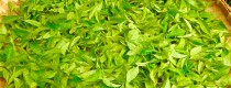
Gude Village is a picturesque area with over 2,600 residents and more than 2,300 acres of tea gardens.
The name “Gude” is believed to come from Yi or Dai languages, meaning “village under the mountain ridge,” though local villagers have various interpretations of its origin. Some interpret “Gude” as the English word “good,” symbolizing that Gude Village is a good place and Gude tea is excellent.
2. Cultural Aspects of Gude Village
Wuliangshan Town is a major tea-producing area in Nanjiang County, with tea cultivation being the local pillar industry. The Yi, Han, Bai, and Miao ethnic groups living in Wuliangshan all have tea gardens in nearly every household. The total tea garden area in the town is 30,100 acres, with over 10,000 ancient tea trees.
Nanjiang County is situated on the ancient Dian-Tibet Tea Horse Road and has long been known as the “Hometown of Tea.” Tea cultivation in the Wuliangshan and Ailao Mountain regions began during the Tang Dynasty, and Nanjiang has a long history of tea production and sales.
In 2022, Nanjiang produced 6,980 tons of pressed tea, accounting for 82% of the county’s total tea production. Nanjiang’s Fenghuang pressed tea is sold in Guangdong, Shanghai, Beijing, Xi’an, Hong Kong, and exported to Korea and Malaysia, gaining a strong market reputation.
Nanjiang County has vigorously developed its tea industry in recent years, benefiting from a good ecological environment. It has become a key tea-producing county and one of China’s top ten ecological tea-producing counties. With policy support and poverty alleviation measures, the county has expanded its tea gardens to 110,000 acres, with 26,000 tea-growing households, 35 tea enterprises, and 35 tea cooperatives.
The thriving tea industry has significantly increased the income of Gude Village’s residents. Many villagers have bought vehicles, built new houses, and even purchased property in the county seat. Tea is not only a primary source of income but also an important offering for guests, reflecting the villagers’ hospitality.
3. Ancient Trees in Gude Village
Gude Village is home to an ancient tea tree known as the “Thousand-Year Tea King,” located at an altitude of about 2,100 meters in the Wuliang Mountains. This tree often becomes a focal point for tea enthusiasts visiting the village.
King of The Tea Tree in XiaoGudee Village in Nanjian County is over 1,200 years old, about 16 meters tall, with a canopy spreading 9.2 meters in diameter. Its trunk has a diameter of 55 centimeters and a circumference of 171 centimeters, belonging to the cultivated Yunnan big leaf tea variety. Despite its age, this ancient tea tree remains vigorous, with lush branches and leaves. It produces nearly 50 kilograms of fresh tea and over 20 kilograms of tea fruits annually.
According to Guo Wenxing, who manages the ancient tree, the exact age is uncertain but can be traced back to the Qing Dynasty’s Kangxi period. In 1940, local landlords and post-liberation tea estates cultivated tea here. Today, the ancient tree is surrounded by newer tea trees and remains lush and vibrant, symbolizing Gude Village.
The “Thousand-Year Tea King” attracts many tea enthusiasts and tourists who come to taste its tea and enjoy the scenery. The tea produced from this ancient tree is known for its excellent aftertaste, unique aroma, and durability, making it highly sought after.
The Wuliangshan tea area primarily consists of cultivated wild ancient tea tree clusters, with some ancient tea trees honored as “Tea Kings.” Villages with ancient tea resources categorize and name their tea to aid in protection and management. While this approach may be somewhat informal, it plays a positive role in preserving ancient tea tree resources.
Wuliangshan Mountain
Wuliang Mountain, formerly known as Mengle mountain (蒙乐山), is located in the west of Jingdong Yi Autonomous County, Pu’er City, Yunnan Province, between 23 ° 57 ‘- 24 ° 44’ n and 100 ° 22 ‘- 101 ° 04’ E. Jingdong Yi Autonomous County covers an area of 2581 square kilometers. Wuliang Shan starts from Nanjian Yi Autonomous County in the northwest and extends to Zhenyuan (镇沅), Jinggu (景谷)and other places in the southwest, Lancang River in the West and Chuanhe River (川河) in the East.
Wuliang Mountain, known as Mengle mountain in ancient times, is named after the meaning of “towering into the clouds, immeasurable in the area”. The mountain branches extend to the East and West and area in the shape of a fan. The geological structure includes limestone, sandstone, shale, low valley, flat dam and hills. Coniferous, broad-leaved and mixed forests grow here. Except growing the Widely distributed Simao Pine, rare and precious trees also grow here. There are tigers, leopards, bears, deer, boars, monkeys, donkeys, rock sheep, water deer, peacocks, silver pheasants and other animals in the primitive forest.
Introduction of Wuliangshan Mountain
Wuliangshan National Nature Reserve is located in the southeast of Nanjian County, in the middle and upper part of Wuliangshan Mountain. The west part is the Lancang River Valley. It is a narrow strip with a length of 33 kilometers from north to south and 6 kilometers from east to west. The total area of the reserve is 7583 hectares.
Reserve covers an area of 230 square kilometers, stretching 50 kilometers from north to south and 7 kilometers from east to west. At the joint of Hengduan Mountain Ranges and Yunnan-Guizhou Plateau, Wuliang Mountain Nature Reserve is included in the sub-valley area of the south part of Hengduan Mountain Ranges.
Climate
The climate zone here is between mid subtropical and south subtropical zones.
Rare Plants
Over 1,500 species of higher plants can be found in the nature reserve and the natural conditions are quite variable. The vegetation exhibits a coverage percentage of 91 and boasts flora families such as Fagaceae, Theaceae, Lauraceae and Magnoliaceae etc, including Pinus kesiya (Simao pine), Pinus yunnanensis (Yunnan pine or Burma pine), dumosa, Tetracentraceae, Alcimandra cathcartii (long-pistil magnolia), red magnolia, Pterospermum kingtungense, Acrocarpus fraxinifolius, Mangifera sylvatica, longan, red Chinese toon, Rhododendron, Chinese torreya, tree fern, Michelia floribunda (multi-flower michelia) and Chinese yew etc. Complicated but favorable natural conditions have created cozy shelters and habitats for wild lives.
Rare Animals
Protected rare animals in Wuliang Mountain Nature Reserve include black gibbon, slow Loris, tiger, leopard, golden cat, zibet, sambar deer, musk deer, goral, mandarin duck, and green peacock etc. There are approximately 271 species of birds, accounting for 23 percent in China and 35 percent in Yunnan Province.
Cherry Blossoms Valley
Cherry Blossoms Valley of Wuliangshan is in the tea plantation of Huaqing Tea Company of Dali. Many Taiwanese merchants rented this tea garden many years ago. Because of the growth of tea trees, they planted winter cherry blossoms in the tea garden. A few years later, as the cherry tree grows up, the gorgeous photos have brought a considerable tourism industry to the local area, and it has become a popular tourist destination favored by many people in a short time.
They are open from late November to mid-December every winter, and the flowering period lasts for about 25 days. Therefore, people who want to see the cherry blossom valley style must confirm the flowering period.
Wuliang Mountain, also known historically as Mengle Mountain, is the western branch of the Yunling Range in the Hengduan Mountains. It is located in Jingdong Yi Autonomous County, Pu’er City, Yunnan Province, China, between 100°03′ ~ 101°07′ E longitude and 23°20′ ~ 25°34′ N latitude. The mountain range runs in a northwest-southeast direction. The ridge line is around 2500 meters in elevation, with deep valleys on both the east and west sides, and a relative height of over 1500 meters. The main peak, Bijiashan, has an elevation of 3370 meters.
The Wuliang Mountain area consists primarily of Mesozoic red lacustrine sandstone and shale, with a small amount of intrusive igneous rock. It is an erosional block mountain range. The climate varies horizontally, with the southern part experiencing a northern tropical and southern subtropical plateau monsoon climate, the central part a mid-subtropical plateau monsoon climate, and the northern part a mid-subtropical and northern subtropical plateau monsoon climate. The vertical climate bands are well-developed, and the region is rich in plant and animal resources.
Formation and Evolution
Wuliang Mountain was formed after the uplift of the plateau, cut into deep canyons by the Lancang and Yuan Rivers and their tributaries. The top is relatively flat, with a significant plateau surface and several collapsed basins.
Location and Extent
Wuliang Mountain, historically known as Mengle Mountain, is located in Jingdong Yi Autonomous County, Pu’er City, Yunnan Province, between 100°03′ ~ 101°07′ E longitude and 23°20′ ~ 25°34′ N latitude. The main ridge stands between the Yangbi River, Heihui River, Lancang River, and the Xihe River, Weishan River, and Bayanjing. It stretches from the Zijin Mountain and Wuyin Mountain in Weishan County, south of the Xier River, east-southeast through Nanjiang, Jingdong, and Zhenyuan counties, reaching the Ganbazi Mountain near the border of Ning’er and Jinggu counties. The range is approximately 260 kilometers long in a northwest-southeast direction. The main part extends about 80 kilometers from south of Yangjie River in Nanjiang to the border of Jingdong and Zhenyuan, with a width of 10 to 15 kilometers.
Geographical Environment
Geology:
Wuliang Mountain is a tectonic erosional mountain range, part of the southern branch of the Yunling Range. Most of the mountain is composed of Mesozoic Jurassic, Cretaceous, and Tertiary red lacustrine strata, with limestone, sandstone, and shale exposed. It is characterized by Mesozoic red lacustrine sandstone and shale, with some intrusive igneous rocks.
Topography:
The terrain of Wuliang Mountain is higher in the north and lower in the south, with an average elevation of 1800 meters. The ridge line is around 2500 meters, with deep valleys on the east and west sides and a relative height of over 1500 meters.
Climate:
Wuliang Mountain has a subtropical monsoon climate, with significant variations in climate zones and natural zones. Horizontally, the southern part has a northern tropical and southern subtropical plateau monsoon climate, the central part a mid-subtropical plateau monsoon climate, and the northern part a mid-subtropical and northern subtropical plateau monsoon climate.
Hydrology:
The Lancang River and Lixian River (the upper reaches of Bayanjing River) flow from northwest to south and southeast along the mountain range, with upstream tributaries forming a feather-like network and downstream tributaries branching out.
Vegetation:
The vegetation of Wuliang Mountain is characterized by significant horizontal zonation due to the cutting action of the Lancang River. The area has well-developed vertical vegetation zones.
Mountain Relations
Belonging Mountain Range:
Wuliang Mountain is part of the Yunling Range’s western branch in the Hengduan Mountains. It extends south from the Diancang Mountain. The range’s secondary ridges spread out in a fan shape. The western and eastern branches of the Yunling Range extend south to Weishan County and Midu County, gradually widening and lowering, with elevations generally below 3000 meters. This region is referred to as the residual Yunling Range, with the eastern branch being Ailao Mountain and the western branch being Wuliang Mountain.
Major Peaks:
- Bijiashan: The main peak of Wuliang Mountain, with an elevation of 3370 meters.
Resources
Plant Resources:
Wuliang Mountain is home to over 1500 species of higher plants, with a forest coverage rate of 91%.
Historical and Cultural
Origin of the Name:
Wuliang Mountain is named for its grand and expansive mountain structure.
Conservation and Research
Ecological Protection:
In 1986, the Wuliang Mountain National Nature Reserve was established. It was upgraded to a national nature reserve in 2000. The reserve covers 309.38 square kilometers and primarily protects endangered wildlife resources, including the black-crowned gibbon, gray langur, and black-necked long-tailed pheasant, as well as the subtropical montane moist evergreen broadleaf forest ecosystem.
Nearby Attractions
You Might Like
- 1 Day Kunming Stone Forest Tour by High Speed Train

- 9 Days Yunnan High Speed Train Tour from Vientiane (Laos) to Kunming, Dali, Lijiang, Shangri La
- 3 Days Puer City Ethnic Culture Tour to Lancang and Ximeng Counties
- 4 Days Haba Snow Mountain Climbing Tour from Lijiang
- 1 Day Dali to Lijiang Tour
- 7 Days Thailand- China Porsche Self-driving Tour from Chiang Mai to Jinghong
- 13 Days Three Parallel Rivers Circle Adventure with Tiger Leaping Gorge and Yubeng Village Hiking Tour
- 3 Days Kunming Jiaozi Snow Mountain Hiking Tour with Dongchuan Red Land


King of The Tea Tree of Wuliang Mountain in Xiaogude Village of Nanjian County, Dali
Chinese Name: 南涧县无量山镇小古德村茶树王 English Name:King of The Tea Tree in Xiaogude Village in Nanjian County, Dali Location:南涧县无量山镇小古德村子 King of The Tea in Xiaogude Village is located in Xiaogude Tea...
Xiaogude Tea Garden of Wuliang Mountain in Nanjian County, Dali
Chinese Name: 南涧县无量山镇古德茶园 English Name:XiaoGude Tea Mountain in Nanjian County, Dali Location:南涧县无量山镇小古德村子 Yunnan Province has two Gude Villages: one is located in Anding Township, Jingdong Yi Autonomous County, and...
Wuliang Mountain in Yunnan
Wuliangshan Mountain Wuliang Mountain, formerly known as Mengle mountain (蒙乐山), is located in the west of Jingdong Yi Autonomous County, Pu’er City, Yunnan Province, between 23 ° 57 ‘-...
Tips Before Travel
Bring copies of your passport
Don't assume you're restricted to the main hubs of Beijing and Shanghai, our tours can start from any city.
Register with your embassy
For your safety, please register with the Embassy.
Always have local cash
Exchange some local currency for your trip
Our Team
Customize a Trip
Start planning your tailor-made holiday to China by contacting one of our specialists. Once enquired, you’ll get a response within 0.5~23.5 hours.
Latest Articles
Yunnan Travel from Dalian of Liaoning
2025-06-14Yunnan Travel from Datong of Shanxi
2025-06-14Yunnan Travel from Fuzhou of Fujian
2025-06-14Yunnan Travel from Guangzhou of Guangdong
2025-06-14Contact Info

