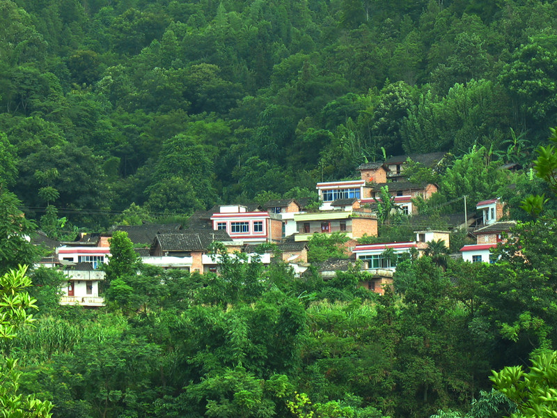
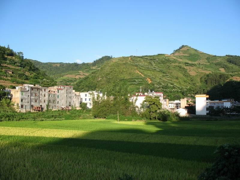
Chinese Name: 楚雄市鹿城镇
English Name: Lucheng Town of Chuxiong City in Chuxiong Prefecture
Geographic Location
Huajia Township (花甲乡) is located in the northwest of Funing County (富宁县), Wenshan Prefecture (文山州), Yunnan Province (云南省). It borders Dongbo Township (洞波乡) to the east, Xinhua Town (新华镇) to the south, Babao (八宝) and Banbang (板蚌) Townships of Guangnan County (广南县) to the west, and Ayong Township (阿用乡) to the north. Huajia Township (花甲乡) is 60 kilometers away from the county seat of Funing (富宁县城), with convenient transportation.
Cultural History
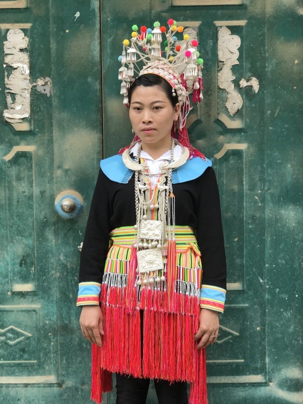
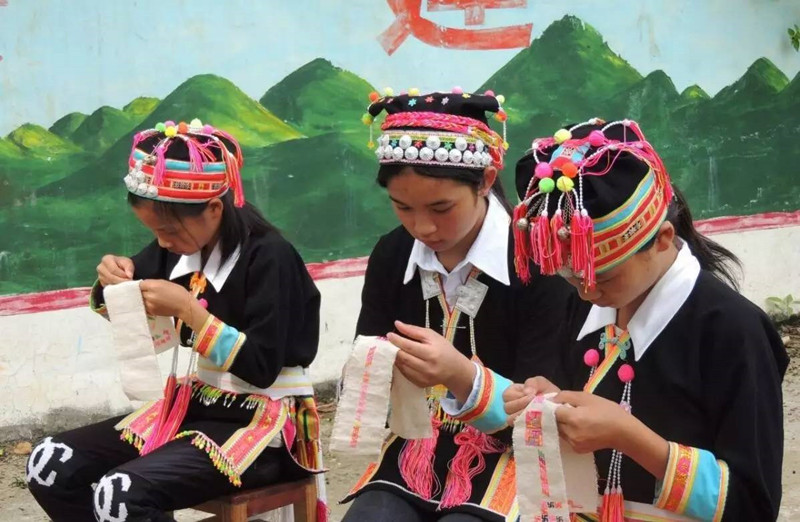
Huajia Township (花甲乡) is an important part of Funing County’s (富宁县) revolutionary base areas and has a rich history of red culture. The township administers eight villagers’ committees and 105 village groups, inhabited by various ethnic groups including Zhuang, Han, Miao, Yao, and Yi.
Folk Customs
Huajia Township (花甲乡) boasts rich and colorful folk customs, featuring:
- Da Bei Festival (打背节): Popular in parts of Funing County (富宁县), this festival is celebrated by Miao youth from the 3rd to the 15th day of the first lunar month.
- Zhuang Ethnic “Longduan Street” (陇端街): Also known as “Flower Street” (花街), it is the most grandiose annual traditional festival for the Zhuang people, held between January and March during the agricultural off-season.
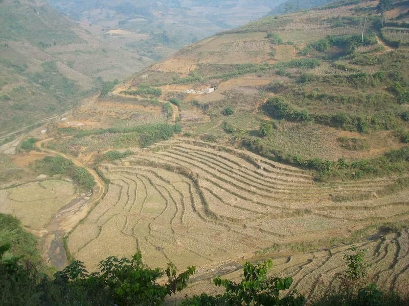
- Naye Terraced Fields Culture (那耶梯田文化): Naye Village (那耶村) in Huajia Township (花甲乡) is famous for its expansive ten-thousand-mu terraced fields, making it an excellent destination for photography and experiencing farming culture.
Weather and Best Time to Visit
Huajia Township (花甲乡) enjoys a South Asian tropical monsoon climate, characterized by hot, rainy summers and cold, dry winters, with four distinct seasons. The best times to visit are spring and autumn when the weather is pleasant and the natural scenery is most beautiful.
Recommended Attractions, Visit Duration, and Tickets
- Naye Terraced Fields Ecotourism Area (那耶梯田生态旅游区): Covering about 10,000 mu, these contiguous terraced fields resemble steps ascending to the sky and showcase ancient farming civilization. Recommended visit duration is 2–3 hours, with free admission.
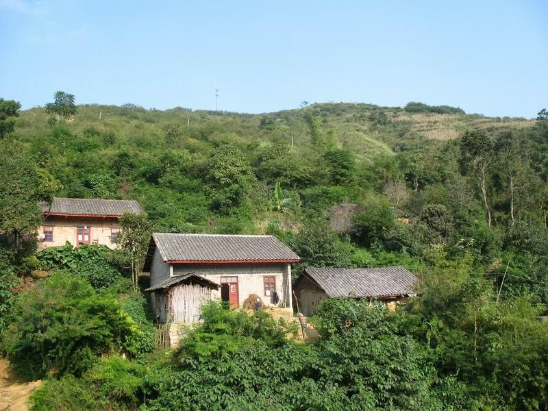
- Traditional Villages of Huajia Township (花甲乡传统村落): Visitors can explore well-preserved traditional buildings and experience unique ethnic culture and natural landscapes. Recommended visit duration is 1–2 hours, and entry is free.
Transportation
- Public Transportation: Take a bus from Funing County (富宁县城) to Huajia Township (花甲乡), with a travel time of about 1 hour.
- Self-Driving: Depart from Funing County (富宁县城) and drive along the county road for approximately 60 kilometers, with a journey time of around 1 hour.
Local Cuisine
Huajia Township (花甲乡) and its surrounding areas offer a variety of specialty foods, such as sticky rice cakes, flower rice, grilled shredded meat, and cold chicken.
Shopping
Visitors can buy local specialty agricultural products such as blueberries, chili peppers, and flue-cured tobacco. Traditional handicrafts like Zhuang embroidery and silver jewelry are also popular.
Accommodation
There are several farm stays and guesthouses in and around Huajia Township (花甲乡), offering affordable options priced at 50–100 RMB per person per night. For more comfortable accommodations, hotels in Funing County (富宁县城) are available.
Travel Tips
- Respect local customs, especially when visiting traditional villages and participating in folk activities.
- Protect the environment and avoid littering.
- If engaging in hiking or outdoor activities, check the weather forecast in advance and take necessary safety precautions.
Suggested Itinerary
- Day 1: Depart from Funing County (富宁县城) to Huajia Township (花甲乡). Visit the Naye Terraced Fields Ecotourism Area (那耶梯田生态旅游区) to experience ethnic culture and natural landscapes. Stay overnight at a local farm stay.
- Day 2: Continue exploring Huajia Township (花甲乡), experiencing the folk culture of the traditional villages. Return to Funing County (富宁县城) in the afternoon to conclude the trip.
Huajia Township (花甲乡) is a charming settlement of ethnic minorities, offering not only unique natural landscapes but also rich ethnic culture. Whether strolling through ancient villages or marveling at the magnificent terraced fields, you will feel the vibrant ethnic atmosphere. We hope you have an unforgettable journey here.
Geographic Location
Ayong Township (阿用乡) is located in the northwest of Funing County (富宁县), Wenshan Prefecture (文山州), Yunnan Province (云南省), between 105°30′–105°45′ E and 23°50′–24°10′ N. It borders Naneng Township (那能乡) to the east, Dongbo Township (洞波乡) to the southeast, and Huajia Township (花甲乡) to the south. To the southwest, it is adjacent to Banbang Township (板蚌乡) of Guangnan County (广南县), and to the northwest, it faces Nazuo Township (那佐乡) of Xilin County (西林县) and Gaolong Township (高龙乡) of Tianlin County (田林县) across the Xiyang River (西洋江). It borders Nabi Township (那比乡) of Tianlin County (田林县) to the north. The township government is located about 65 kilometers from the county seat of Funing (富宁县城).
Cultural History
Ayong Township (阿用乡) has a long history. In the early Ming Dynasty, it was established as Ayong Outpost (阿用哨). In the 27th year of Emperor Guangxu’s reign during the Qing Dynasty (1901), the outpost was abolished and merged into Huajia District (花甲区). In the third year of the Republic of China (1914), Ayong Township (阿用乡) was established, and after several administrative adjustments, it was officially restructured as a township in 1988. As of 2020, Ayong Township (阿用乡) administers six administrative villages.
Folk Customs
Ayong Township (阿用乡) is home to a diverse range of ethnic groups, including the Zhuang, Han, Miao, Yao, and Yi peoples. The local folk culture is rich and varied, characterized by a strong Zhuang cultural atmosphere. Particularly notable is the traditional “Folk Opera Troupe” in Pingdui (平兑). Additionally, Ayong Township (阿用乡) celebrates various ethnic festivals, such as the Zhuang people’s “Longduan Street” (陇端街) and the Miao people’s “Da Bei Festival” (打背节).
Weather and Best Time to Visit
Ayong Township (阿用乡) enjoys a subtropical monsoon climate, with an average annual temperature of 19°C and an average annual rainfall of 1,200.6 millimeters. The frost-free period averages 340 days per year. The best times to visit are spring and autumn, when the weather is pleasant and the natural scenery is at its most beautiful.
Recommended Attractions, Visit Duration, and Tickets
- Traditional Villages of Ayong Township (阿用乡传统村落): Visitors can explore well-preserved traditional buildings and experience the unique ethnic culture and natural beauty. Recommended visit duration is 2–3 hours, with free admission.
- Xiyang River Basin (西洋江流域): Hydropower stations such as Naliu Level 8 (那柳8级) and Dongba Level 9 (洞巴9级) have been built here, with a reservoir area of over 900 mu, ideal for leisure visits. Recommended visit duration is 1–2 hours, with free admission.
Transportation
- Public Transportation: Take a bus from Funing County (富宁县城) to Ayong Township (阿用乡), with a travel time of about 1 hour.
- Self-Driving: Depart from Funing County (富宁县城) and drive along the county road for about 65 kilometers, taking approximately 1 hour.
Local Cuisine
Ayong Township (阿用乡) and surrounding areas offer a variety of local specialties such as sticky rice cakes, flower rice, grilled shredded meat, and cold chicken.
Shopping
Local specialty agricultural products such as sugarcane, oil tea, star anise, Chinese fir, tung oil, ginger, and cinnamon are available for purchase. In addition, visitors can buy traditional handicrafts such as Zhuang embroidery and silver jewelry.
Accommodation
There are several farm stays and guesthouses in and around Ayong Township (阿用乡), offering budget-friendly accommodations generally priced between 50–100 RMB per person per night. For more comfortable lodging, hotels in Funing County (富宁县城) are a good choice.
Travel Tips
- Respect local customs, especially when visiting traditional villages and participating in folk activities.
- Protect the environment by not littering.
- For hiking or outdoor activities, check the weather forecast in advance and take necessary safety precautions.
Suggested Itinerary
- Day 1: Depart from Funing County (富宁县城) and head to Ayong Township (阿用乡). Visit the traditional villages and experience the ethnic culture and natural beauty. Stay overnight at a local farm stay.
- Day 2: Visit the Xiyang River Basin (西洋江流域) to enjoy the natural scenery. Return to Funing County (富宁县城) in the afternoon to conclude the trip.
Ayong Township (阿用乡) is a charming settlement of ethnic minorities, offering both unique natural landscapes and rich ethnic culture. Whether you are strolling through ancient villages or admiring magnificent natural scenery, you will experience the deep ethnic charm. We hope you enjoy an unforgettable journey here.
Geographic Location
Dongbo Yao Ethnic Township (洞波瑶族乡) is located in the north-central part of Funing County (富宁县), Wenshan Prefecture (文山州), Yunnan Province (云南省). It borders Zhesang Township (者桑乡) to the east, Guichao Town (归朝镇) to the south, Xinhua Town (新华镇) and Huajia Township (花甲乡) to the west, and is adjacent to Naneng Township (那能乡) and Ayong Township (阿用乡) to the north. The township government is situated approximately 56.5 kilometers from the county seat of Funing (富宁县城).
Cultural History
Dongbo Yao Ethnic Township (洞波瑶族乡) was established in 1988 and is one of the two Yao ethnic townships in Wenshan Prefecture (文山州). The Yao people have a long history and unique cultural traditions, practicing Taoism and venerating Panhu (盘瓠) as their ancestor. The “Initiation Ceremony” (度戒) is one of their significant cultural traditions, aimed at providing moral education to young people.
Folk Customs
The folk culture of Dongbo Yao Ethnic Township (洞波瑶族乡) is rich and colorful, mainly including:
- Initiation Ceremony (度戒仪式): For the Indigo Yao (蓝靛瑶) boys, the ceremony is held between the ages of 10 and 18, while for the Big Board Yao (大板瑶), it is performed after marriage. The ceremony, presided over by highly respected Daoist priests and masters, lasts between three to seven days.
- Panwang Festival (盘王节): Celebrated annually on the 16th day of the 10th lunar month, the Yao people sing and dance to express gratitude to Panwang (盘王) for his protection.
- Wedding Customs: Unique wedding traditions include drinking “marriage wine” and eating “Parents’ Chicken” (爹妈鸡).
- Taboo Culture: The Yao people observe various taboos, such as avoiding the consumption of dog, cat, and horse meat, and refraining from working in the mountains on the first Tiger Day of the lunar new year.
Weather and Best Time to Visit
Dongbo Yao Ethnic Township (洞波瑶族乡) has a subtropical monsoon climate, with an average annual temperature of 19.3°C, annual rainfall of 1,184.1 millimeters, and a frost-free period of 321 days. The best time to visit is in spring and autumn when the weather is pleasant and the natural scenery is at its peak.

 Dongbo Yao Ethnic Town of Funing County in Wenshan Prefecture
Recommended Attractions, Visit Duration, and Tickets
- Traditional Villages of Dongbo Yao Ethnic Township (洞波瑶族乡传统村落): Visitors can explore well-preserved traditional architecture and experience the unique ethnic culture and natural beauty. Recommended visit duration is 2–3 hours, with free admission.
- Panwang Festival Celebration (盘王节庆祝活动): If visiting at the right time, participate in the Panwang Festival on the 16th day of the 10th lunar month to experience the traditional festive culture of the Yao people.
Transportation
- Public Transportation: Take a bus from Funing County (富宁县城) to Dongbo Yao Ethnic Township (洞波瑶族乡), with a travel time of about 1 hour.
- Self-Driving: Depart from Funing County (富宁县城) and drive along the county road for approximately 56.5 kilometers, with a travel time of about 1 hour.
Local Cuisine
Dongbo Yao Ethnic Township (洞波瑶族乡) and surrounding areas offer a variety of local delicacies such as sticky rice cakes, flower rice, grilled shredded meat, and cold chicken.
Shopping
You can purchase local specialty agricultural products such as star anise, sugarcane, and ginger. Additionally, traditional Yao handicrafts like Yao embroidery and silver jewelry are also available.
Accommodation
There are several farm stays and guesthouses in and around Dongbo Yao Ethnic Township (洞波瑶族乡), offering affordable accommodations typically priced between 50–100 RMB per person per night. For more comfortable lodging options, hotels in Funing County (富宁县城) are recommended.
Travel Tips
- Respect local customs, especially when visiting traditional villages and participating in folk activities.
- Protect the environment and avoid littering.
- If planning for hiking or outdoor activities, check the weather forecast in advance and take necessary safety precautions.
Suggested Itinerary
- Day 1: Depart from Funing County (富宁县城) and head to Dongbo Yao Ethnic Township (洞波瑶族乡). Visit traditional villages to experience the ethnic culture and natural scenery. Stay overnight at a local farm stay.
- Day 2: Continue exploring Dongbo Yao Ethnic Township (洞波瑶族乡) to experience local culture and daily life. Return to Funing County (富宁县城) in the afternoon to conclude the trip.
Dongbo Yao Ethnic Township (洞波瑶族乡) is a captivating settlement of ethnic minorities, rich in both natural beauty and ethnic culture. Whether strolling through ancient villages or participating in the vibrant Panwang Festival, visitors can deeply experience the unique ethnic charm. We hope you enjoy a memorable journey here.
Geographic Location
Naneng Township (那能乡) is located in the northeastern part of Funing County (富宁县), Wenshan Prefecture (文山州), Yunnan Province (云南省). It borders Bo’ai Town (剥隘镇) to the east, Dongbo Township (洞波乡) to the south, Ayong Township (阿用乡) to the west, and adjoins Nabi Township (那比乡) of Tianlin County (田林县) in Guangxi (广西) to the north. The township government is situated 86 kilometers from the county seat of Funing (富宁县城), covering an administrative area of 393.33 square kilometers.
Cultural History
Naneng Township (那能乡) boasts a long history. In the early Ming Dynasty, the areas of Nanang (那南), Nagua (那瓜), and Xiningxi (西宁夕) were established. In the 27th year of the Guangxu period of the Qing Dynasty (1901), Xiningxi (夕) was abolished and incorporated into Bo’ai District (剥隘区). In the third year of the Republic of China (1914), Naneng Township (那能乡) was officially established under Bo’ai District (剥隘区). In 1951, Xining Township (西宁乡) was abolished, and Naneng (那能) and Liumu (六母) Townships were formed under Dongbo (洞波). In 1960, Naneng Commune (那能公社) was established, and in 1984 it was reorganized into a district. In 1988, it was restructured into a township.
Folk Customs
Naneng Township (那能乡) is home to a diverse population, including the Zhuang, Han, and Yao ethnic groups. The folk culture is rich and varied. Among them, the Zhuang people’s “Longduan Festival” (陇端节) is an important traditional event. During the festival, activities such as cultural performances, Zhuang opera, antiphonal singing, and traditional Zhuang cuisine experiences are held. In addition, Naneng Township (那能乡) features historical Red Culture sites such as the Ganbang Red Army Cave (甘帮红军洞), forming an important part of the revolutionary heritage.
Weather and Best Time to Visit
Naneng Township (那能乡) enjoys a subtropical monsoon climate with an average annual temperature of 18.9°C, annual rainfall of 1,653 millimeters, and an average of 360 frost-free days per year. The best time to visit is during spring and autumn, when the climate is pleasant and the natural scenery is at its most beautiful.
Recommended Attractions, Visit Duration, and Tickets
- Ganbang Red Army Cave (甘帮红军洞): Listed as a third batch of prefecture-level cultural relics protection units in Wenshan Prefecture (文山州), it holds significant historical importance. Recommended visit duration is 1–2 hours, with free admission.
- Traditional Villages of Naneng Township (那能乡传统村落): Visitors can explore well-preserved traditional architecture and experience the unique ethnic culture and natural beauty. Recommended visit duration is 2–3 hours, with free admission.
Transportation
- Public Transportation: Take a bus from Funing County (富宁县城) to Naneng Township (那能乡), with a travel time of about 1 hour.
- Self-Driving: Depart from Funing County (富宁县城) and drive along county roads for a total distance of approximately 86 kilometers, with a travel time of about 1 hour.
Local Cuisine
Naneng Township (那能乡) and its surrounding areas offer a variety of specialty foods such as sticky rice cakes, flower rice, grilled shredded meat, and cold chicken.
Shopping
Visitors can buy local specialty agricultural products such as tea, star anise, and ginger.
Accommodation
There are several farm stays and guesthouses in and around Naneng Township (那能乡), offering affordable accommodations typically priced between 50–100 RMB per person per night. For more comfortable lodging, hotels in Funing County (富宁县城) are available.
Travel Tips
- Respect local customs, especially when visiting traditional villages and participating in folk activities.
- Protect the environment by not littering.
- If planning outdoor activities or hiking, check weather conditions in advance and take appropriate safety precautions.
Suggested Itinerary
- Day 1: Depart from Funing County (富宁县城) and head to Naneng Township (那能乡). Visit Ganbang Red Army Cave (甘帮红军洞) and traditional villages to experience ethnic culture and natural scenery. Stay overnight at a local farm stay.
- Day 2: Continue exploring Naneng Township (那能乡), immersing yourself in the local culture and lifestyle. Return to Funing County (富宁县城) in the afternoon to conclude the trip.
Naneng Township (那能乡) is a charming ethnic minority settlement, rich in both unique natural scenery and profound historical culture. Whether strolling through ancient villages or visiting revolutionary heritage sites, visitors can deeply experience the vibrant ethnic atmosphere. We hope you enjoy a memorable journey here.
Geographic Location
Zhesang Township (者桑乡) is located in the northeastern part of Funing County (富宁县), Wenshan Prefecture (文山州), Yunnan Province (云南省). It borders Panshui Township (泮水乡) of Baise City (百色市), Guangxi (广西) to the east, Guichao Town (归朝镇) to the south, Dongbo Township (洞波乡) to the west, and Naneng Township (那能乡) and Bo’ai Town (剥隘镇) to the north. The township government is situated 54 kilometers from the county seat of Funing (富宁县城). National Highway 323 (国道323线), the Guangkun Expressway (广昆高速公路), and the Yungui Railway (云桂铁路) run through the township, making transportation very convenient.
Cultural History
Zhesang Township (者桑乡) has a long and rich history. During the Yuan Dynasty, it was part of Luozuo Prefecture (罗佐州). In the early Ming Dynasty, it was incorporated into Fuzhou (富州). In the 27th year of the Guangxu period of the Qing Dynasty (1901), Zhesang (者桑) was designated as the Third District. In 1966, Zhesang Commune (者桑公社) was established after separating from Bo’ai (剥隘), and in 1987, it was reorganized from a district into a township.
Folk Customs
Zhesang Township (者桑乡) is inhabited by three ethnic groups: the Zhuang, Han, and Yao, with ethnic minorities accounting for 98.5% of the population. The local folk culture is vibrant, featuring traditional festivals such as the “Longduan Festival” (陇端节) celebrated by the Zhuang, and unique wedding customs and cultural taboos of the Yao people.
Weather and Best Time to Visit
Zhesang Township (者桑乡) enjoys a subtropical plateau monsoon climate with distinct seasons. It experiences a frost-free period year-round, with mild and humid weather and abundant rainfall and sunshine. The average annual temperature is 20.7°C, and the annual rainfall averages 1,200 millimeters. The best times to visit are spring and autumn, when the weather is pleasant and the natural scenery is at its best.
Recommended Attractions, Visit Duration, and Tickets
- Traditional Villages of Zhesang Township (者桑乡传统村落): Visitors can explore well-preserved traditional architecture and experience unique ethnic culture and beautiful natural scenery. Recommended visit duration is 2–3 hours, with free admission.
- Tuoniangjiang Scenic Area (驮娘江风景区): Known for its elegance, wonder, clarity, and serenity, it is ideal for leisure tours. Recommended visit duration is 3–4 hours, with an entrance fee of about 50 RMB.
Transportation
- Public Transportation: Take a bus from Funing County (富宁县城) to Zhesang Township (者桑乡), with a travel time of about 1 hour.
- Self-Driving: Depart from Funing County (富宁县城) and drive along National Highway 323 (国道323线), covering a distance of approximately 54 kilometers, taking about 1 hour.
Local Cuisine
Zhesang Township (者桑乡) and the surrounding areas offer many specialty dishes, such as sticky rice cakes, flower rice, grilled shredded meat, and cold chicken.
Shopping
Local specialty agricultural products such as star anise, oil tea, and Wogan oranges (沃柑) are popular purchases. Additionally, visitors can buy ethnic handicrafts such as Yao embroidery and silver jewelry.
Accommodation
Several farm stays and guesthouses are available in and around Zhesang Township (者桑乡), offering affordable accommodations typically priced between 50–100 RMB per person per night. For more comfortable lodging options, hotels in Funing County (富宁县城) are recommended.
Travel Tips
- Respect local customs and traditions, especially when visiting traditional villages and participating in folk activities.
- Protect the environment by not littering.
- If planning outdoor activities or hiking, check weather conditions in advance and take appropriate safety precautions.
Suggested Itinerary
- Day 1: Depart from Funing County (富宁县城) and head to Zhesang Township (者桑乡). Visit traditional villages to experience ethnic culture and natural beauty. Stay overnight at a local farm stay.
- Day 2: Visit the Tuoniangjiang Scenic Area (驮娘江风景区) to explore the natural landscapes. Return to Funing County (富宁县城) in the afternoon to conclude the trip.
Zhesang Township (者桑乡) is a captivating ethnic minority settlement, rich in both unique natural beauty and vibrant ethnic culture. Whether strolling through ancient villages or admiring magnificent landscapes, visitors can immerse themselves in a deep and colorful ethnic atmosphere. We hope you enjoy an unforgettable journey here.
Geographic Location
Gula Township (谷拉乡) is located in the eastern part of Funing County (富宁县), Wenshan Prefecture (文山州), Yunnan Province (云南省). It borders Panshui Township (泮水乡) of Baise City (百色市), Kuiwei Township (魁圩乡) of Jingxi City (靖西市), and Longhe Township (龙合乡) of Napo County (那坡县) in Guangxi Zhuang Autonomous Region (广西壮族自治区) to the southeast. It neighbors Guichao Town (归朝镇) and Zhesang Township (者桑乡) of Funing County (富宁县) to the northwest. The township government is located 80 kilometers from the county seat, covering an administrative area of 386 square kilometers.
Cultural History
Gula Township (谷拉乡) has a long and rich history. During the Yuan Dynasty, it was part of Luozuo Prefecture (罗佐州). In the early Ming Dynasty, it was incorporated into Fuzhou (富州). After the “Gaitu Guiliu” (改土归流) reforms in the 27th year of the Guangxu reign (1901) during the Qing Dynasty, it belonged to the Second District of Guichao (皈朝第二区). During the Republic of China period, Dehua Township (德化乡) and Liangui Township (连桂乡) were established. After the abolition of districts in 1940, Aijing Township (爱敬乡) was set up with its seat at Gula (谷拉). In 1950, Gula Township (谷拉乡) was formally established, which was changed to Gula Commune (谷拉公社) in 1958, and restored as a township in 1988.
Folk Customs
Gula Township (谷拉乡) is home to various ethnic groups, including the Zhuang, Han, and Yao, with ethnic minorities making up 92.77% of the total population. The township has preserved many unique folk traditions, such as the “Longduan Festival” (陇端节) celebrated by the Zhuang, which has been listed as part of Yunnan Province’s (云南省) intangible cultural heritage. In addition, Gula Township (谷拉乡) boasts rich red culture resources, including sites like Gantun Red Army Cave (甘屯红军洞) and Longsuo Red Army Cave (龙所红军洞), both recognized as part of the third batch of prefecture-level cultural heritage protection units in Wenshan Prefecture (文山州).
Weather and Best Time to Visit
Gula Township (谷拉乡) has a subtropical monsoon climate, characterized by mild winters without severe cold. The average annual temperature is 25°C, and the average annual precipitation is 1,200.6 millimeters. The best times to visit are in spring and autumn when the weather is pleasant and the natural scenery is at its peak.
Recommended Attractions, Visit Duration, and Tickets
- Gantun Red Army Cave (甘屯红军洞): Located in Gantun Village Group (甘屯村小组) of Longdeng Village Committee (龙灯村委会), this is an important site of red cultural heritage. Recommended visit duration is 1–2 hours, and it is open to the public free of charge.
- Longsuo Red Army Cave (龙所红军洞): Situated within Gula Township (谷拉乡), it is an integral part of the revolutionary base area of Yunnan, Guizhou, and Guangxi (滇黔桂革命根据地). Recommended visit duration is 1 hour, with free admission.
- Guliu Fortress (谷留碉堡): A modern historical site located in Gula Township (谷拉乡). Recommended visit duration is 1 hour, and admission is free.
Transportation
- Public Transportation: Take a bus from Funing County (富宁县城) to Gula Township (谷拉乡), with a journey time of about 1 hour.
- Self-Driving: Depart from Funing County (富宁县城) and drive along the county road for about 80 kilometers, taking approximately 1 hour.
Local Cuisine
Gula Township (谷拉乡) and its surrounding areas offer a variety of specialty foods, including sticky rice cakes, flower rice, grilled shredded meat, and cold chicken.
Shopping
Local specialty agricultural products such as star anise, oil tea, and sugarcane are popular purchases.
Accommodation
There are several farm stays and guesthouses available in Gula Township (谷拉乡) and its surrounding areas, offering affordable options typically priced between 50–100 RMB per person per night. For more comfortable lodging, hotels in Funing County (富宁县城) are recommended.
Travel Tips
- Respect local customs, especially when visiting red cultural heritage sites and participating in folk activities.
- Protect the environment by refraining from littering.
- If planning to engage in hiking or outdoor activities, check the weather in advance and ensure appropriate safety measures are taken.
Suggested Itinerary
- Day 1: Depart from Funing County (富宁县城) and head to Gula Township (谷拉乡). Visit Gantun Red Army Cave (甘屯红军洞) to experience red culture. Stay overnight at a local farm stay.
- Day 2: Visit Longsuo Red Army Cave (龙所红军洞) and Guliu Fortress (谷留碉堡) to appreciate the historical atmosphere. Return to Funing County (富宁县城) in the afternoon to conclude the trip.
Gula Township (谷拉乡) is a charming old revolutionary area, offering not only unique natural scenery but also a wealth of red culture and ethnic traditions. Whether wandering through ancient villages or visiting revolutionary heritage sites, you will be immersed in a rich historical atmosphere. We hope you have an unforgettable journey here.
Geographic Location
Banlun Township (板仑乡) is located in the southeastern part of Funing County (富宁县), Wenshan Prefecture (文山州), Yunnan Province (云南省), between 105°37′–105°46′ east longitude and 23°24′–23°41′ north latitude. The township government is 20 kilometers from the county seat of Funing County (富宁县城) and 28 kilometers from the county seat of Napo County (那坡县) in Guangxi Zhuang Autonomous Region (广西壮族自治区). It borders Chengxiang Town (城厢镇) and Baidu Township (百都乡) of Napo County (那坡县) and Guichao Town (归朝镇) of Funing County (富宁县) to the east, Tianpeng Town (田蓬镇) to the south, Lida Town (里达镇) to the west, and Xinhua Town (新华镇) to the north. Major transportation routes such as National Highways 323 and 359, the Guangkun Expressway (广昆高速公路), the Fulong Expressway (富龙高速公路), the Gaobang–Napo provincial highway, and the Yunnan-Guangxi Railway (云桂铁路) pass through the area, making it an important gateway for Yunnan to access coastal regions.
Cultural History
Banlun Township (板仑乡) has a long history, with villages already established during the Song Dynasty. In the early Ming Dynasty, Banlun Post (板仑哨) was set up. In 1901 (27th year of the Guangxu reign, Qing Dynasty), the post was abolished and replaced with a township under the “Gaitu Guiliu” (改土归流) reforms. During the Republic of China period, the name changed several times. Banlun Township (板仑乡) was formally established in 1949 and officially reestablished in 1988.
Folk Customs
Banlun Township (板仑乡) is home to five ethnic groups: Zhuang, Han, Miao, Yao, and Yi, with ethnic minorities comprising 86.96% of the total population. Many unique cultural traditions are preserved here, such as the “Longduan Festival” (陇端节) of the Zhuang people, which has been included in the intangible cultural heritage list of Yunnan Province (云南省). Banlun Township (板仑乡) also has rich red cultural resources, including sites like Gantun Red Army Cave (甘屯红军洞) and Longsuo Red Army Cave (龙所红军洞), both listed as part of the third batch of prefecture-level cultural heritage protection units in Wenshan Prefecture (文山州).
Weather and Best Time to Visit
Banlun Township (板仑乡) has a subtropical monsoon climate, with an average annual temperature of 19°C and a frost-free period of 327 days. The best times to visit are spring and autumn, when the weather is pleasant and the natural scenery is at its most beautiful.
Recommended Attractions, Visit Duration, and Tickets
- Gantun Red Army Cave (甘屯红军洞): An important site of red cultural heritage. Recommended visit duration is 1–2 hours, and it is open to the public free of charge.
- Longsuo Red Army Cave (龙所红军洞): A key part of the Yunnan-Guizhou-Guangxi Revolutionary Base Area (滇黔桂革命根据地). Recommended visit duration is 1 hour, with free admission.
- Traditional Villages of Banlun Township (板仑乡传统村落): Visitors can explore well-preserved traditional architecture and experience the unique ethnic culture and natural scenery. Recommended visit duration is 2–3 hours, with free admission.
Transportation
- Public Transportation: Take a bus from Funing County (富宁县城) to Banlun Township (板仑乡), with a journey time of about 30 minutes.
- Self-Driving: Depart from Funing County (富宁县城) and drive along National Highway 323 for about 20 kilometers, with a journey time of approximately 30 minutes.
Local Cuisine
Banlun Township (板仑乡) and the surrounding areas offer a variety of local specialties, such as sticky rice cakes, flower rice, grilled shredded meat, and cold chicken.
Shopping
Visitors can buy local specialty agricultural products such as star anise, oil tea, and sugarcane. Additionally, locally crafted ethnic products like Yao embroidery and silver jewelry are popular choices.
Accommodation
There are several farm stays and guesthouses available in Banlun Township (板仑乡) and nearby areas, with affordable prices typically ranging from 50–100 RMB per person per night. For more comfortable accommodations, hotels in Funing County (富宁县城) are recommended.
Travel Tips
- Respect local customs, especially when visiting red cultural heritage sites and participating in folk activities.
- Protect the environment by properly disposing of trash.
- If planning hiking or other outdoor activities, check the weather forecast in advance and take necessary safety precautions.
Suggested Itinerary
- Day 1: Depart from Funing County (富宁县城) to Banlun Township (板仑乡). Visit Gantun Red Army Cave (甘屯红军洞) and explore the traditional villages to experience ethnic culture and natural beauty. Stay overnight at a local farm stay.
- Day 2: Visit Longsuo Red Army Cave (龙所红军洞) to appreciate its historical significance. Return to Funing County (富宁县城) in the afternoon to conclude the trip.
Banlun Township (板仑乡) is a charming settlement predominantly inhabited by ethnic minorities, offering not only unique natural landscapes but also a wealth of red and ethnic cultural heritage. Whether strolling through ancient villages or visiting revolutionary sites, you will be immersed in a rich historical atmosphere. We hope you enjoy an unforgettable journey here.
Geographic Location
Muyang Town (木央镇) is located in the southwestern part of Funing County (富宁县), Wenshan Prefecture (文山州), Yunnan Province (云南省), between 105°30′–105°39′ east longitude and 23°23′–23°35′ north latitude. It borders Lida Town (里达镇) to the east, Tianpeng Town (田蓬镇) to the south, Donggan Town (董干镇) and Xinzai Township (新寨乡) of Malipo County (麻栗坡县) to the west, and Heizhiguo Township (黑支果乡) of Guangnan County (广南县) to the north. The town government is located 46 kilometers from the county seat of Funing County (富宁县城), covering an area of 577.8 square kilometers.
Cultural History
Muyang Town (木央镇) has a long and rich history. In 1737 (the second year of the Qianlong reign, Qing Dynasty), it was established as Muyang Camp (木央营) under Baoning County (宝宁县) of Guangnan Prefecture (广南府). In 1915 (fourth year of the Republic of China), it was incorporated into the Tianpeng Special Seventh District (田蓬对汛特别第七区) of the Malipo Defense Special Area (麻栗坡对汛特别区). In 1949, it belonged to Jinhe Township (金禾乡) of Tianpeng District (田蓬区). In 1950, it was known as Muyang Township (木央乡) of Tianpeng District (田蓬区). In 1957, it was placed under Funing County (富宁县) as the Sixth District (Tianpeng) (田蓬) Muyang Township (木央乡). In 1958, it became Muyang Administrative District (木央管理区) of Muyang Commune (木央公社). In 1962, it reverted to Tianpeng District (田蓬区) as Muyang Commune (木央公社). In 1969, it was known as Muyang Brigade (木央大队) of Muyang Commune (木央公社). In 1984, it was renamed Muyang Township (木央乡). In 2006, the township system was abolished, and Mulun Township (睦伦乡) was merged into Muyang Town (木央镇).
Folk Customs
Muyang Town (木央镇) is home to six ethnic groups: Han, Zhuang, Miao, Yao, Yi, and Gelao. Many distinctive folk traditions are preserved here, such as the “Longduan Festival” (陇端节) of the Zhuang people, which has been included in the intangible cultural heritage list of Yunnan Province (云南省). Muyang Town (木央镇) also boasts abundant red cultural resources, including sites like Gantun Red Army Cave (甘屯红军洞) and Longsuo Red Army Cave (龙所红军洞), both recognized as part of the third batch of prefecture-level cultural heritage protection units in Wenshan Prefecture (文山州).
Weather and Best Time to Visit
Muyang Town (木央镇) has a subtropical monsoon climate characterized by abundant rainfall, warm and humid weather, higher temperatures in spring than in autumn, and distinct dry and wet seasons. The multi-year average temperature is 15.6°C, with an average of 326 frost-free days per year. The best times to visit are in spring and autumn when the weather is pleasant and the natural scenery is at its best.
Recommended Attractions, Visit Duration, and Tickets
- Gantun Red Army Cave (甘屯红军洞): An important red cultural heritage site. Recommended visit duration is 1–2 hours, and it is open to the public free of charge.
- Longsuo Red Army Cave (龙所红军洞): A vital part of the Yunnan-Guizhou-Guangxi Revolutionary Base Area (滇黔桂革命根据地). Recommended visit duration is 1 hour, with free admission.
- Traditional Villages of Muyang Town (木央镇传统村落): Explore well-preserved traditional architecture and experience unique ethnic culture and natural landscapes. Recommended visit duration is 2–3 hours, free of charge.
Transportation
- Public Transportation: Take a bus from Funing County (富宁县城) to Muyang Town (木央镇), with a journey time of about 1 hour.
- Self-Driving: Depart from Funing County (富宁县城) and drive along county roads for about 46 kilometers, taking approximately 1 hour.
Local Cuisine
Muyang Town (木央镇) and its surrounding areas offer a variety of local delicacies such as sticky rice cakes, flower rice, grilled shredded meat, and cold chicken.
Shopping
Visitors can purchase local specialty agricultural products such as star anise, oil tea, and sugarcane. Additionally, ethnic crafts such as Yao embroidery and silver jewelry are popular souvenirs.
Accommodation
There are several farm stays and guesthouses available in Muyang Town (木央镇) and the surrounding areas, offering affordable prices typically ranging from 50–100 RMB per person per night. For more comfortable accommodation options, hotels in Funing County (富宁县城) are recommended.
Travel Tips
- Respect local customs, especially when visiting red cultural heritage sites and participating in folk activities.
- Protect the environment by properly disposing of waste.
- If planning hiking or outdoor activities, check the weather forecast in advance and take necessary safety precautions.
Suggested Itinerary
- Day 1: Depart from Funing County (富宁县城) to Muyang Town (木央镇). Visit Gantun Red Army Cave (甘屯红军洞) and explore the traditional villages, experiencing ethnic culture and natural beauty. Stay overnight at a local farm stay.
- Day 2: Visit Longsuo Red Army Cave (龙所红军洞) to appreciate the historical atmosphere. Return to Funing County (富宁县城) in the afternoon to conclude the trip.
Muyang Town (木央镇) is a captivating settlement predominantly inhabited by ethnic minorities, offering not only unique natural landscapes but also rich red cultural and ethnic heritage. Whether strolling through ancient villages or visiting revolutionary sites, you will experience a profound sense of history. We hope you have an unforgettable journey here.
Geographic Location
Tianpeng Town (田蓬镇) is located in the southwestern part of Funing County (富宁县), Wenshan Prefecture (文山州), Yunnan Province (云南省). To the east, it borders Baidu Township (百都乡) and Baisheng Township (百省乡) of Napo County (那坡县) in Guangxi Zhuang Autonomous Region (广西壮族自治区); to the south, it borders Miao Wang (苗王) and Tongwen (同文) Counties in Vietnam; to the west, it neighbors Donggan Town (董干镇) in Malipo County (麻栗坡县), Wenshan Zhuang and Miao Autonomous Prefecture (文山壮族苗族自治州); and to the north, it connects with Muyang Town (木央镇) of Funing County (富宁县). The town government is located 69 kilometers from the county seat, and the border line stretches for 60 kilometers.
History and Culture
Tianpeng Town (田蓬镇) has a long history, with settlements established during the Ming Dynasty. In 1946, during the 35th year of the Republic of China, Tianpeng Town (田蓬镇) was officially founded. In 1958, Tianpeng Commune (田蓬公社) was established. It became Tianpeng District (田蓬区) in 1984, and Tianpeng Town (田蓬镇) again in 1988. In 2006, Langheng Township (郎恒乡) was merged into Tianpeng Town (田蓬镇). In July 2014, Tianpeng Town (田蓬镇) was designated as a National Key Town by seven ministries including the Ministry of Housing and Urban-Rural Development.
Folk Customs
Tianpeng Town (田蓬镇) is home to five ethnic groups: Han, Miao, Yao, Yi, and Zhuang. Many unique folk traditions are preserved here, such as the Zhuang ethnic festival “Longduan Festival (陇端节),” which has been listed as an intangible cultural heritage of Yunnan Province (云南省). The town also has rich red culture resources, such as Gantun Red Army Cave (甘屯红军洞) and Longsuo Red Army Cave (龙所红军洞), both recognized as third-batch prefecture-level cultural heritage sites in Wenshan Prefecture (文山州).
Climate and Best Time to Visit
Tianpeng Town (田蓬镇) features a mild hilly and mountainous climate typical of southeastern Yunnan. The highest elevation is 1,790 meters, and the lowest is 653 meters, with an average temperature of 15.6℃. Annual rainfall averages 1,210.6 millimeters, and the annual average sunshine duration is 112.8 hours. The best times to visit are spring and autumn, when the climate is pleasant and the natural scenery is at its most beautiful.
Recommended Attractions, Visiting Time, and Admission Fees
- Gantun Red Army Cave (甘屯红军洞): An important red cultural heritage site. Recommended visiting time: 1–2 hours. Admission: Free.
- Longsuo Red Army Cave (龙所红军洞): A vital part of the revolutionary bases in Yunnan, Guizhou, and Guangxi. Recommended visiting time: 1 hour. Admission: Free.
- Traditional Villages of Tianpeng Town (田蓬镇传统村落): Preserved traditional architecture and vibrant ethnic culture. Recommended visiting time: 2–3 hours. Admission: Free.
Transportation
- Public Transportation: You can take a bus from the county seat of Funing County (富宁县) to Tianpeng Town (田蓬镇), approximately a 1-hour journey.
- Self-driving: Starting from Funing County (富宁县), follow the county roads for about 69 kilometers, approximately a 1-hour drive.
Local Cuisine
Tianpeng Town (田蓬镇) and its surrounding areas offer a variety of local delicacies, such as glutinous rice cakes (糯米粑), colored flower rice (花米饭), roasted shredded meat (烤肉丝), and cold chicken (凉鸡).
Shopping
Local specialties like star anise (八角), camellia oil (油茶), and sugarcane (甘蔗) are available for purchase. You can also find traditional handicrafts such as Yao embroidery (瑶族刺绣) and silver jewelry (银饰).
Accommodation
Tianpeng Town (田蓬镇) and nearby areas offer rural guesthouses and homestays, with prices generally ranging from 50 to 100 RMB per person per night. For more comfortable lodging, hotels in the county seat of Funing County (富宁县) are also available.
Travel Tips
- Respect local customs and traditions, especially when visiting red culture sites or participating in ethnic events.
- Protect the environment and avoid littering.
- If planning outdoor activities such as hiking, check weather conditions in advance and take appropriate safety precautions.
Suggested Itinerary
Day 1: Depart from Funing County (富宁县), head to Tianpeng Town (田蓬镇), visit Gantun Red Army Cave (甘屯红军洞) and traditional villages to experience ethnic culture and natural scenery. Stay overnight in a local guesthouse.
Day 2: Visit Longsuo Red Army Cave (龙所红军洞) to appreciate the historical atmosphere. Return to Funing County (富宁县) in the afternoon, concluding the trip.
Tianpeng Town (田蓬镇) is a charming border town, rich in both natural beauty and cultural heritage. Whether strolling through ancient villages or exploring red cultural sites, visitors can experience a profound sense of history. We hope you have an unforgettable journey here.
Geographic Location
Lida Town (里达镇) is located in the southwestern part of Funing County (富宁县), Wenshan Prefecture (文山州), Yunnan Province (云南省), between 105°30′–105°39′ east longitude and 23°23′–23°35′ north latitude. It borders Banlun Township (板仑乡) to the east, Tianpeng Town (田蓬镇) to the south, Muyang Town (木央镇) to the west, and Xinhua Town (新华镇) to the north. The town government is located 19.5 kilometers from the county seat of Funing County (富宁县), with a total area of 190 square kilometers.
History and Culture
Lida Town (里达镇) has a long history. During the Yuan Dynasty, it was first settled by the family of Li Da (李大), a Yi ethnic group member, from whom the town derived its name through a phonetic evolution. In the late Ming Dynasty, it was incorporated into Guangnan (广南). During the Republican period, it was designated as a district. In 1957, it was reassigned to Funing County (富宁县), and in 1958, it was restructured from a district into a commune. It was merged into Chengguan District (城关区) in 1961, reestablished as a district in 1962, became a commune again in 1969, reverted to a district in 1984, and finally was upgraded to a town in 1988.
Folk Customs
Lida Town (里达镇) is home to five ethnic groups: Han, Zhuang, Miao, Yao, and Yi, with ethnic minorities accounting for 44.8% of the total population. Many unique folk customs are preserved here, including the Zhuang people’s “Longduan Festival (陇端节).”
Climate and Best Time to Visit
Lida Town (里达镇) experiences a subtropical monsoon climate with distinct vertical climate zones. The annual average temperature is 15℃, and the average annual rainfall is 1,213.7 millimeters. The best times to visit are spring and autumn when the weather is pleasant and the natural scenery is at its most beautiful.
Recommended Attractions, Visiting Time, and Admission Fees
- Longtou Well (龙头井): One of the famous attractions in Lida Town (里达镇). Recommended visiting time: 1–2 hours. Admission: Free.
- Niaowang Mountain (鸟王山): Known for its beautiful natural scenery, ideal for hiking and photography. Recommended visiting time: 2–3 hours. Admission: Free.
Transportation
- Public Transportation: Buses are available from the county seat of Funing County (富宁县) to Lida Town (里达镇), with a journey time of about 30 minutes.
- Self-driving: Drive from Funing County (富宁县) along the county roads for approximately 19.5 kilometers, taking about 30 minutes.
Local Cuisine
Lida Town (里达镇) and its surrounding areas offer many local delicacies, such as glutinous rice cakes (糯米粑), colored flower rice (花米饭), roasted shredded meat (烤肉丝), and cold chicken (凉鸡).
Shopping
You can buy local agricultural specialties such as star anise (八角), camellia oil (油茶), and sugarcane (甘蔗).
Accommodation
Lida Town (里达镇) and nearby areas offer rural guesthouses and homestays with affordable prices, generally ranging from 50 to 100 RMB per person per night. For more comfortable accommodation, hotels in Funing County (富宁县) are available.
Travel Tips
- Respect local customs and traditions, especially when visiting traditional villages and participating in folk events.
- Protect the environment by not littering.
- If planning to hike or engage in outdoor activities, check the weather forecast in advance and take necessary safety precautions.
Suggested Itinerary
Day 1: Depart from Funing County (富宁县) to Lida Town (里达镇), visit Longtou Well (龙头井) and Niaowang Mountain (鸟王山) to experience the natural scenery and ethnic culture. Stay overnight in a local guesthouse.
Day 2: Continue exploring Lida Town (里达镇) to experience local culture and daily life. Return to Funing County (富宁县) in the afternoon to conclude the trip.
Lida Town (里达镇) is a charming settlement inhabited by various ethnic groups, offering not only unique natural landscapes but also rich ethnic culture. Whether strolling through ancient villages or admiring the breathtaking natural scenery, visitors can deeply feel the vibrant ethnic atmosphere. We hope you have an unforgettable journey here.
Geographic Location
Bo’ai Town (剥隘镇) is located in the northeastern part of Funing County (富宁县), Wenshan Prefecture (文山州), Yunnan Province (云南省), at 105°54′–106°12′ east longitude and 23°48′–24°08′ north latitude. It is the easternmost township in Yunnan Province (云南省). Bo’ai borders Yangxu Town (阳圩镇) of Baise City (百色市), Guangxi (广西) to the east, Zhesang Township (者桑乡) to the south, Naneng Township (那能乡) to the west, and Bagui Township (八桂乡) of Tianlin County (田林县), Guangxi (广西) to the north. The town government is located 67 kilometers from the Funing County (富宁县) seat, and the administrative area covers 494 square kilometers.
History and Culture
Bo’ai Town (剥隘镇) has a long history. In the early Ming Dynasty, several outposts and hamlets were established, including Hongbang Outpost (洪邦哨), Zheyi (者仪), Zhening (者宁), Bo’ai (剥隘), Naliang (那良), and Baie (百峨). During the Kangxi period of the Qing Dynasty, military troops were stationed at Bo’ai. In 1901 (Guangxu Year 27), the outposts were abolished, and the area became the Fourth District. In 1914 (Republic of China Year 3), it was renamed the Fifth District. In 1940 (Republic of China Year 29), the district was abolished and replaced with Wuying Town (武英镇). In August 1949, the town was dissolved and reorganized as the Third District. In 1958, it became a commune. The district was restored in 1961, including Zhesang Township (者桑乡) and Naneng Township (那能乡). In 1969, it reverted to a commune, and the two townships were separated from Bo’ai. In 1984, the commune was again changed into a district, and in 1988, it was restructured as a town.
Folk Customs
Bo’ai Town (剥隘镇) is inhabited mainly by the Zhuang, Han, and Yao ethnic groups, with ethnic minorities accounting for 98% of the population. The town retains many unique folk traditions. Among them is the Zhuang festival “Longduan Street (陇端街),” also known as “Flower Street (花街),” which is the most important traditional festival of the Zhuang people. Another cultural highlight is the Poya Folk Songs (坡芽山歌), a unique form of Zhuang ethnic music that preserves rich traditional customs.
Climate and Best Time to Visit
Bo’ai Town (剥隘镇) enjoys a subtropical monsoon climate with warm temperatures and no extreme seasons. Winters are mild and summers are not excessively hot. The area has abundant rainfall, distinct vertical climate zones, and a long frost-free period. The average annual temperature is 21.9°C, with January averaging 13.1°C and July 27.7°C. The best times to visit are spring and autumn when the weather is pleasant and the natural scenery is most attractive.
Recommended Attractions, Visiting Time, and Admission Fees
- Poya Village (坡芽村): A picturesque Zhuang ethnic village with beautiful scenery and vibrant culture. Recommended visit time: 2–3 hours. Admission: Free.
- Bo’ai Revolutionary Activity Site (富宁剥隘革命活动旧址): Located in Bo’ai Town (剥隘镇), this site is a third-level protected cultural relic of Wenshan Prefecture (文山州) and holds great historical value. Recommended visit time: 1–2 hours. Admission: Free.
- Tuoniang River Scenic Area (驮娘江景区): The river originates in Guangnan County (广南县) and flows through northern Bo’ai, forming part of the Xijiang tributary of the Pearl River system. This scenic area is known for its tranquil beauty and is ideal for relaxing tours. Recommended visit time: 3–4 hours. Admission: Approximately 50 RMB.
Transportation
- Public Transport: Buses from the Funing County (富宁县) seat to Bo’ai Town (剥隘镇) take about 1 hour.
- Self-driving: From the Funing County (富宁县) seat, drive along National Highway 323 for about 67 kilometers; travel time is around 1 hour.
Local Cuisine
Bo’ai Town (剥隘镇) and surrounding areas offer a variety of local specialties such as glutinous rice cakes (糯米粑), flower rice (花米饭), roasted shredded meat (烤肉丝), and cold chicken (凉鸡).
Shopping
Visitors can purchase local agricultural products such as star anise (八角), camellia oil (油茶), and sugarcane (甘蔗). Local handicrafts like Yao embroidery (瑶族刺绣) and silver jewelry (银饰) are also popular.
Accommodation
There are various guesthouses and rural homestays in and around Bo’ai Town (剥隘镇), with affordable prices typically ranging from 50 to 100 RMB per person per night. For more comfortable accommodation, visitors may opt to stay in hotels in Funing County (富宁县).
Travel Tips
- Respect local customs, especially when visiting revolutionary sites and participating in cultural events.
- Protect the environment by avoiding littering.
- Check the weather forecast in advance if engaging in hiking or outdoor activities, and take necessary safety precautions.
Suggested Itinerary
Day 1: Depart from Funing County (富宁县) and arrive at Bo’ai Town (剥隘镇). Visit Poya Village (坡芽村) to experience Zhuang culture and natural beauty. Stay overnight at a local guesthouse.
Day 2: Visit the Bo’ai Revolutionary Activity Site (富宁剥隘革命活动旧址) to explore local history. In the afternoon, tour the Tuoniang River Scenic Area (驮娘江景区). Return to Funing County (富宁县) in the evening to conclude the trip.
Bo’ai Town (剥隘镇) is a captivating multi-ethnic community offering not only unique natural landscapes but also rich revolutionary and ethnic cultural heritage. Whether strolling through ancient villages or exploring historical sites, visitors will be immersed in a strong sense of history and culture. We hope you enjoy a memorable journey here.
You Might Like
- 1 Day Shangri-La Lamaist Monasteries Tour

- 6 Days XishuangBanna Damenglong Ethnic Villages Hiking Tour
- 8 Days Dali, Lincang and Puer Tea Tour with Fengqing Dianhong Black Tea Factory
- 5 Days Lijiang City Tour with Tiger Leaping Gorge Hiking Adventure
- 8 Days China Students Education Tour to Yuanyang Hani Rice Terraces
- 7 Days XishuangBanna Cycling Tour with Ethnic Minorite Discovery and Ancient Tea Culture Experience
- 6 Days Kunming-Dali Tea Culture Tour to Wuliangshan Mountain
- 15 Days Southwest Yunnan Ancient Tea Culture Tour


Lucheng Town of Chuxiong City in Chuxiong Prefecture
Chinese Name: 楚雄市鹿城镇 English Name: Lucheng Town of Chuxiong City in Chuxiong Prefecture...
Huajia Town of Funing County in Wenshan Prefecture
Geographic Location Huajia Township (花甲乡) is located in the northwest of Funing County (富宁县), Wenshan Prefecture (文山州), Yunnan Province (云南省). It borders Dongbo Township (洞波乡) to the east, Xinhua...
Ayong Town of Funing County in Wenshan Prefecture
Geographic Location Ayong Township (阿用乡) is located in the northwest of Funing County (富宁县), Wenshan Prefecture (文山州), Yunnan Province (云南省), between 105°30′–105°45′ E and 23°50′–24°10′ N. It borders Naneng...

Dongbo Yao Ethnic Town in Funing County, Wenshan
Geographic Location Dongbo Yao Ethnic Township (洞波瑶族乡) is located in the north-central part of Funing County (富宁县), Wenshan Prefecture (文山州), Yunnan Province (云南省). It borders Zhesang Township (者桑乡) to...
Naneng Town of Funing County in Wenshan Prefecture
Geographic Location Naneng Township (那能乡) is located in the northeastern part of Funing County (富宁县), Wenshan Prefecture (文山州), Yunnan Province (云南省). It borders Bo’ai Town (剥隘镇) to the east,...
Zhesang Town of Funing County in Wenshan Prefecture
Geographic Location Zhesang Township (者桑乡) is located in the northeastern part of Funing County (富宁县), Wenshan Prefecture (文山州), Yunnan Province (云南省). It borders Panshui Township (泮水乡) of Baise City...
Gula Town of Funing County in Wenshan Prefecture
Geographic Location Gula Township (谷拉乡) is located in the eastern part of Funing County (富宁县), Wenshan Prefecture (文山州), Yunnan Province (云南省). It borders Panshui Township (泮水乡) of Baise City...
Banlun Town of Funing County in Wenshan Prefecture
Geographic Location Banlun Township (板仑乡) is located in the southeastern part of Funing County (富宁县), Wenshan Prefecture (文山州), Yunnan Province (云南省), between 105°37′–105°46′ east longitude and 23°24′–23°41′ north latitude....
Muyang Town of Funing County in Wenshan Prefecture
Geographic Location Muyang Town (木央镇) is located in the southwestern part of Funing County (富宁县), Wenshan Prefecture (文山州), Yunnan Province (云南省), between 105°30′–105°39′ east longitude and 23°23′–23°35′ north latitude....
Tianpeng Town of Funing County in Wenshan Prefecture
Geographic Location Tianpeng Town (田蓬镇) is located in the southwestern part of Funing County (富宁县), Wenshan Prefecture (文山州), Yunnan Province (云南省). To the east, it borders Baidu Township (百都乡)...
Lida Town of Funing County in Wenshan Prefecture
Geographic Location Lida Town (里达镇) is located in the southwestern part of Funing County (富宁县), Wenshan Prefecture (文山州), Yunnan Province (云南省), between 105°30′–105°39′ east longitude and 23°23′–23°35′ north latitude....
Boai Town of Funing County in Wenshan Prefecture
Geographic Location Bo’ai Town (剥隘镇) is located in the northeastern part of Funing County (富宁县), Wenshan Prefecture (文山州), Yunnan Province (云南省), at 105°54′–106°12′ east longitude and 23°48′–24°08′ north latitude....
Tips Before Travel
Bring copies of your passport
Don't assume you're restricted to the main hubs of Beijing and Shanghai, our tours can start from any city.
Register with your embassy
For your safety, please register with the Embassy.
Always have local cash
Exchange some local currency for your trip
Our Team
Customize a Trip
Start planning your tailor-made holiday to China by contacting one of our specialists. Once enquired, you’ll get a response within 0.5~23.5 hours.
Latest Articles

Contact Info

