Ancient Villages
Ancient Villages in Yunnan
Chinese Name: 大理市挖色镇挖色村
English Name: Wase Village of Wase Town in Dali City
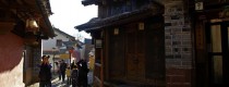
Was Village is part of Wase Town in Dali city. It is located in Wase Town, a suburb of Dali which is located 0.5 km from the Case Town west side. The path to the city is a concrete road that provides fast transport, which is 40 kilometers from Dali. The city is adjacent to Guangyi village of the eastside, the village of Haiyin in the south, Erhai Lake on the western side, and Kanglang village on the north. Twelve village groups competence.
Wase Village is Wase Town’s Headquarters, anciently known as “Seaside Village” (“海边邑’’). The Bai calls it “gebonao” (“阁波脑”), means a place on the sea. Since when do not know, there is a ravine found in the village that produces attractive minerals of ore. Many people all over the country just come to the village because of the coloring materials as a dyestuff. That is why the local people called it “wangsheng” (“王生’’), in Chinese we call it “Wase”, and that’s means where you dig dyestuff coloring products.
The history of Wase Village
Back 4000 years ago, the Wase Village was inhabited. After the establishment of PRC, many archeologists many times have excavation in archeology. A large number of tools used in Neolithic and Bronze Ages by ancient people have been found on the “chiwen” island (赤文岛) of an ancient fishing village ruin. It is rumored that there is an old viewing tower on the highest of the island. The summer town built by Nanzhao was also next to the cliffs of the reef. In the last few years, when the road around the east coast of the Erhai lake was being constructed, important cultural relics such as knives and stone axes, pendants and steel knives were still found, as were the bronze weapons, steel boots, copper axes and spear, crickets and axes. Therefore, place dig dyestuff as well as one of the Bai history cultural sources. In the early time during the War between Tang Dynasty and Nanzhao, Li Mi was training the sailor in Wase, and he has been fighting with Nanxun several times. During the Qing Dynasty when Du Wenxiu Uprising, he used to build a city on the “guanzai” (观在), a sentry box and viewpoint near the sea. Even in early liberation, the buildings were destroyed, the site still exists today.
In the last hundred years, the Erhai Lake in the east has long been the centre of political and economic growth, as well as the transport of water and land. The caravans and the boats are passing through “Wase”, so some mark ‘ Wase ‘ the old tea horse lane on Erhai Laka’s east coast. Scholars and authors have always called it as a place endowed with the fine spirits of the universe and be endowed with supernatural talents. (“山川毓秀、人杰地灵”)
Discover the natural beauty of “Wase”
The scenery of “Wase” is extremely beautiful. The “qigu” mountain(旗鼓山) standing tall and upright on the south, the “chiwen” island(赤文岛) lie down like a tiger on the Erhai Lake, peculiar rocks and ravines at the south. Look around when you climb over, you’ll see one of Erhai Lake’s nine bays as the shape of the crescent moon comes to you in pavonine light. The village like a phoenix, float east from the west sea. The view at the peak is absolutely incredible. The Eastern Buddhist Mountain called “jizu” (鸡足山) where the “langyan” tower can be seen. In the South of Xiaguan (下关), Dali City, new city has been built up. At west side, the foot of “cang” mountain(苍山) was covered in mist and the “Erhai” lake(洱海) was as silver as diamond flame and the atmosphere was convent quiet. The “Jade Dragon Snow Mountain”(玉龙雪山) were vampire-white. A wave of white snow went rumbling down the sides. They were all crumpled at the base. Fishing village, “Wase” ancient village, traditional “Bai” buildings with cyan-blue bricks and pink walls are all covered in mist. You’ve never been there in such a picturesque place.
The transport of “Wase” village
Since always, as the main water and land transportation in “Erhai” Lake. There is no motor road. As the new century begins, under government sponsorship the tourist road to “Jzhizu” and “Huanhai East Road” (洱海东路) were being constructed.The transportation landscape of “Wase” is shifting immensely due to the Dali-Lijiang highway and the train pass “Wase” village. At this time, bluestone was used to all main roads. Most of the village lanes are cement roads.The village and beach were swept and tidy by all the clearers. The old town reveals its luminous hand.
The accommodation of “Wase”
There are thousand of hotels, shops, convenience stores and restaurants. Walking on the sightseeing road, marshes and ponds, little bridge flowing water, ditty from the homeward fishing boat you can never forget. Sometimes, birds fly across the pond or rejoice over you. Fully integrated into a lovely plateau of the water village. More and more visitors are coming here, and the local economic growth has increased a lot.
Translated by Wu Hao/吴昊
Chinese Version:
http://daliwase.cn/bbx/1408635-1408635.html?id=35983&newsid=767091
Google Map
Chinese Name:阿鲁老寨
English Name: Alu Laozhai is a village of Aini Ethnic People in Menghai County, Xishuangbanna
1 Day Alu Laozhai Village and Aini Ethnic People Discovery Tour
Ethnic People:Aini People
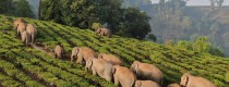
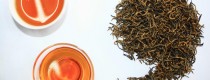
Alula Old Village Alula Old Village is located in Menghai County, Xishuangbanna Prefecture, Yunnan Province, China. It is an ancient village with a long history and strong Wa ethnic culture. The villagers are mainly engaged in tea planting, hunting, and gathering for a living.
Geographical environment Alula Old Village is situated at an altitude of 1,300 meters, surrounded by mountains, with a warm and humid climate. The soil is fertile, suitable for tea growth, which makes tea the main economic source for the villagers.

Alu Laozhai Village, located in Menghai County, Xishuangbanna Prefecture, Yunnan Province, is a fascinating destination to explore the unique culture of the Aini (or Aini) ethnic people. This 1-day tour offers an immersive experience into the traditional lifestyle, customs, and natural beauty of this ancient village.
Morning: Arrival and Village Exploration
Midday: Cultural Immersion and Lunch

Afternoon: Cultural Activities and Scenic Views
Evening: Departure
Travel Tips:
Maps & Resources:
Enjoy your cultural discovery tour of Alu Laozhai Village and immerse yourself in the rich heritage of the Aini people!
Chinese Name: 安宁市禄脿街道密马龙村
English Name: Mimalong Village of Lubiao Subdistrict in Anning City, Kunming
Chinese Name:文山壮族苗族自治州丘北县温浏乡石别村
English Name: Shibie Village of Wenliu Town in Quibei County, Wenshan
Shibu Village, Wenliu Township, Qiubei County is a region with a rich minority culture and is also a beautiful tourist destination. Below are some travel tips for Shibu Village, Wenliu Township, Qiubei County, as well as information on transportation from Qiubei County to Shibu Village.
2.1 Driving Start from Qiubei County, drive along Provincial Highway S240 to Puzhe Black Waterfall Scenic Area, and then turn onto County Road X044 and continue to Shibu Village. The whole journey is about 33 kilometers and takes about 1 hour to drive.
2.2 Public Transportation Take a bus from Qiubei County Bus Station to Puzhe Black Waterfall Scenic Area, and then transfer to a bus to Shibu Village at Puzhe Black Waterfall Scenic Area. The whole journey takes about 1 hour.
Chinese Name: 文山壮族苗族自治州丘北县腻脚乡老寨村
English Name: Laozhai Village of Nijiao Town in Qiubei County, Wenshan
Laozhai Village is a small village group within Nijiao Village in Nijiao Town, Qiubei County. It is located in a mountainous area, approximately 1 kilometer away from the village committee and 1 kilometer from the town center. The village covers a land area of 10 square kilometers, sitting at an elevation of 2,030 meters. It experiences an average annual temperature of 14°C and an annual rainfall of 1,168 millimeters. The climate and geography are suitable for growing crops such as corn and cabbage.
The average cultivated land per capita in Laozhai Village is 1.2 mu (about 0.08 hectares). The village has a registered population of over 1,240 people, with around 1,040 residents living there permanently. In 2013, the average per capita net income for farmers was 6,583 yuan. The primary sources of income for the villagers are farming and animal husbandry.
Laozhai Village has a unique architectural culture developed through generations of living in harmony with the land, following the natural rhythm of the sun and mountains. The village’s residential buildings are constructed with care, featuring grand and robust designs. All village houses are traditional quadrangle courtyard-style buildings, with wooden components and stone materials. The structures are substantial, with meticulously crafted columns, bases, doors, windows, and engraved wooden flower columns. The walls are built using a mixture of five-faced stones, glutinous rice, sand, and ash. The main gate is an arched structure made of semi-circular stone, while the front eaves of the main house are adorned with tri-color decorative brackets. The courtyard is paved with five-faced stones, suitable for drying grains. The quadrangle courtyards have efficient drainage systems that leave visitors in awe. Traditional dwellings make up 79% of the village’s buildings, and their architectural style is well-preserved, showcasing distinctive local cultural characteristics.
Nijiao Laozhai is primarily inhabited by the descendants of the Han people who settled there during the Qing Dynasty. The village contains a cluster of 357 traditional houses, home to over 1,600 people. These traditional buildings are built with large green stones, giving them a rustic and heavy style characteristic of the typical “one-seal” residential architecture.
In recent years, to enhance the preservation of Nijiao Village’s traditional ancient village, Nijiao Town has focused on fire prevention, closely monitoring potential sources of hazards, encouraging community participation, and conducting practical drills to improve the fire response capabilities for traditional ancient villages. The responsibilities for fire safety are clearly defined and implemented.
Chinese Name: 文山壮族苗族自治州丘北县平寨乡革雷村
English Name: Gelei Village of Pingzhai Town in Qiubei County, Wenshan
Gelei Village is situated in a mountainous area, approximately 4 kilometers from the village committee and 30 kilometers from the town center. The village covers a land area of 11.72 square kilometers, with an elevation of 1,242 meters. The annual average temperature is 16°C, and it receives about 1,150 millimeters of rainfall each year. These conditions are ideal for cultivating crops such as rice and corn.
Gelei Village has a total of 366 mu (about 24.4 hectares) of arable land, with an average of 0.4 mu (about 0.027 hectares) per capita. There is also 1,400 mu (about 93.3 hectares) of forested land. The village is divided into two village groups and consists of 174 households. Agriculture and animal husbandry are the primary sources of income for the villagers. The village is characterized by its north-south mountain ranges and the east-west flowing Qing Shui River valley. About 2 kilometers to the east of the village is the Gelei Level 1 Power Station, operated by China Southern Power Grid. A suspension bridge in the village connects a simple mountain road to the Qiubei-Guangnan highway. The geographical setting on the southeastern slope of the Yunnan-Guizhou Plateau, combined with a humid climate and abundant evergreen broadleaf forests, contributes to a pleasant environment. The village is also home to ancient banyan trees that remain green throughout the year.
Gelei Village is located in the middle and lower reaches of the Qing Shui River, with fertile land conducive to the development of agriculture. The river has good water quality, teeming with fish and shrimp, and the presence of ancient banyan trees adds to the village’s picturesque and poetic charm. The village enjoys ample water supply and easy irrigation, but its only drawback is the slightly inconvenient transportation. Despite this, the entire village is well-organized and well-preserved.
The village lies in a river valley with a humid environment, favoring the construction of stilt-style houses, which offer comfortable living conditions. This architectural style is a traditional dwelling form among ethnic minorities in Yunnan Province and has been prevalent since the late Neolithic period. Gelei Zhuang ethnic houses are built near the mountains and water, facing north to south. The village is covered with ancient banyan trees, and all 203 houses are built in the “stilt-style” architecture, featuring a horizontally elongated rectangular layout. The houses vary in size, with some having 3, 4, or 6 compartments. The lower level of these houses is shorter, while the upper level is taller, with the design allowing humans to live on the upper level and livestock to be kept below. The upper level is divided into bedrooms and a central hall by horizontal wooden panels. The central hall serves as a communal space for family activities and hosting guests, featuring a shrine for deities and ancestral tablets. A hearth at one end of the hall is used for cooking, making it a central part of daily life.
Chinese Name: 保山市腾冲市荷花镇民团村坝派村
English Name: Bapai Village of Hehua Town in Tengchong City, Baoshan
“Bapai/坝派” means “a place covered with hemp and pine trees” in the Dai language. Bapai Village is located south of Hehua Town in Tengchong City. The village, situated amidst mountains and rivers, boasts well-preserved residences and temples dating back to the Qing Dynasty. Some of these structures still retain traditional Dai cultural elements, exuding a strong rural architectural charm. The renowned Bapai Village Jiuquan Spring within the area is widely known far and wide.
Bapai Village is located in the southern part of Hetai Town, Tengchong City, within the Min Tuan community. It serves as an important junction on the Tenglong Secondary Highway, situated 27 kilometers from downtown Tengchong. The village covers an area of 1.19 square kilometers and is positioned at 24°56′ N latitude and 98°23′ E longitude, with an average altitude of 1,210 meters.
Climate and Geography:
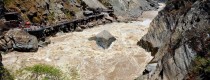
Bapai Village is renowned for its unique spring water, home to Yunnan Province’s largest underground low-temperature spring—the Bapai Giant Spring, also known as “Chushui Cave.” This remarkable spring stretches about 500 meters from north to south and 60 meters from east to west, maintaining a constant temperature of around 19°C year-round. It features a total of 56 spring outlets, three of which have a flow rate of 4 to 5 cubic meters per second.
The Giant Spring has an impressive discharge rate, with water bursting forth from the cave like a dragon, flowing vigorously downstream at nearly 4 tons per second. The spring’s source is Ma’anshan Mountain near Heshun Town, where two mysterious underground rivers converge. The crystal-clear spring water travels over ten kilometers through volcanic cliffs before reaching Bapai Village, remaining unaffected by geothermal influences. In 2002, it was designated a first-level protected area within the Tengchong Volcanic Geothermal National Geological Park due to its geological significance.
At the entrance of the Giant Spring, marked by a white archway inscribed with “Chushui Cave,” visitors descend stone steps into a breathtaking landscape. The sound of roaring water fills the air, and the rushing water flows into a clear pond, creating a serene and picturesque scene surrounded by lush banana trees. The spring water flows continuously, merging into a river downstream before joining the Daying River, a tributary of the Irrawaddy River.
The quality of the Bapai Giant Spring water is exceptional, remaining stable at 5 to 6 degrees higher than other local springs even in winter. It can be used directly as drinking water. In the 1980s, a sugar factory built nearby connected a water pipeline from Chushui Cave, allowing the spring water to be used without treatment. Local lore suggests that the spring water not only enhances beauty but also improves food flavor.
Bapai Village is predominantly inhabited by the Dai ethnic group. The term “Bapai” translates to “a place covered with fragrant herbs” in Dai, reflecting the villagers’ deep connection to water, which nourishes both the land and their livelihoods. The Dai people celebrate the Water Splashing Festival every year in mid-April, gathering near the spring in festive attire to honor water as a vital source of life and fortune.
Bapai’s rich Dai culture is reflected in its culinary offerings, which include unique dishes made from local ingredients. The village is often referred to as a real-life “Monet’s Garden,” with its picturesque scenery and delicious food attracting numerous tourists.
Bapai Village is a charming destination filled with breathtaking scenery and delightful cuisine. The unique natural landscape, coupled with the rich cultural heritage and culinary experiences, makes it a place worth visiting. We eagerly await your arrival for a memorable culinary journey in Bapai!
Chinese Name: 剑川县弥沙乡弥井村
English Name: Mijing Village of Misha Town in Jianchuan County, Dali
Location: Mijing Village is located in Misha Town of Jianchuan County in Dali.
Misha Well is known for its abundant salt mines and was once a major salt town in western Yunnan. It is also one of the origins of the “Salt Horse Ancient Road.” During the Yuan, Ming, and Qing dynasties, embassies, inspection offices, and salt tax offices were established. Misha Salt Well was listed as the “Mother Well,” overseeing surrounding “daughter wells” such as Qiaohou Well and Yunlongla Well. Misha Salt Well includes old wells, dripping wells under rock walls, submerged wells under the west bridge pier, and Shalu wells, Dajing, Xiaojing, and mining wells under the east bridge pier.
Mijin Village is located in the southeast of Mishaxiang, Jianchuan County, Dali Prefecture, Yunnan Province, more than 80 kilometers away from Jianchuan County Town, on both sides of the Mishaxiang River, bordered by Qiaohou Town, Er Yuanxiang, Shaxi Town, and connected to Dayi, Xizhuang, and Dongzhuang villages.
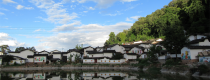
Mijin Village is picturesque, nestled among mountains and rivers. The western part of the village features deep valleys, waterfalls, ancient trees, and streams. The southern part, where Kuisi Pavilion and Sansheng Palace are located, resonates with mountain peaks. The entire village is scattered along the banks of the Mishaxiang River, with adobe houses, secluded lanes, and ancient stone walls, reflecting a strong ethnic character. The sound of mule bells and the smooth bluestone roads record the long history and culture of Mijin, one of the second batch of traditional villages in China.
Mijin Village has a long history and profound cultural heritage. It was once a major salt production town in northwest Yunnan during the era of the Salt Horse Ancient Road. The prosperity of the salt industry made Mijin a bustling place, with markets held every three days and nights. Currently, the village still retains relics from the Salt Horse Ancient Road era, such as the Salt Goddess Mother, Sansheng Palace, Zhao Ying Temple, and ancient theaters.
Historical records state that “Misha” was the combined name of “near Miquan” and “Shazhuijing” during the Tang Dynasty in Nanzhao. Since the Tang Dynasty, salt wells have been established in Misha, known as near Miquan. Misha Well was one of the four major salt wells in western Yunnan at that time.
According to legend, initially, there were no inhabitants near Misha Well. People lived on the flat ground halfway up the mountain. A woman’s cow often secretly ran down to the salt spring to drink salt water. To understand why the cow liked to run downhill, the woman followed her cow and discovered Misha Well. In commemoration of the cow’s discovery of the salt well, every Spring Festival or the eighth day of the fourth lunar month, villagers in Mijin hold a “Dae Gou” (bull dance) activity, simulating primitive agricultural production and sacrificial activities, hoping for a good harvest.
Misha Well is separated from the famous Salt Horse Ancient Road town, Shaxi, by only one mountain. Due to its narrow geographical location, salt from Misha Well had to be transported by mule to Shaxi for distribution. From Shaxi, travelers passed through Mapingguan, then crossed a vast primitive forest to reach Misha Well. The journey from Shaxi to Misha Well required traversing a steep five-li slope, a section of ancient road manually carved on a steep slope. This section of the ancient road is also called “Three Stone Markers” by the people of Misha Well. Legend has it that in ancient times, the steep slope of the five-li slope was often blocked by stones trampled by mule caravans, making it difficult to pass. Passersby developed a habit of picking up three stones each to pile them on both sides of the ancient road. Over time, two stone walls were formed on both sides of the ancient road.
Mijin is famous for salt production, and the legend of the “Salt Goddess Mother,” the founder of the Misha salt industry, has been passed down in the village. Every year on the eighth day of the fourth lunar month, villagers go to Baihua Tan on the western mountaintop of the village to welcome the “Salt Goddess Mother” and hold rich and colorful folk cultural activities, including bull dancing, dragon dancing, lion dancing, fishing, chopping wood, duets of sanxian love songs, and operas. The cultural traditions of fishing, woodcutting, farming, and reading continue to this day.
Along the ancient stone steps, perhaps only the remaining Zhao Ying Temple on the opposite hillside can vaguely explain the past of Misha Well. According to the “Inscription of the Newly Built Zhao Ying Temple,” by Wanli Jiwei (1573), the temple decayed and collapsed… until the second year of Tianqi (1622), when it was completed after forty-nine years of construction.
Sansheng Palace
Misha Well is historically known as a place of “people’s happiness and industry.” It also attracted various foreign religious cultures due to the prosperity of the salt industry. Zhao Ying Temple and Sansheng Palace have always been the center of religious activities in the Misha area. Sansheng Palace is still registered as the activity place of the Taoist Association of Jianchuan County. To this day, Taoist music in Mijin is well preserved and unique. Every July of the lunar calendar, Misha holds a mass festival, including the Yulan Festival, grand vegetarian feasts, water and land processions, to commemorate ancestors and mourn the deceased.
Transportation: Take a bus from Xiaguan Passenger Transport North Station to Jianchuan, 45 yuan per person, from 7:00 to 18:00, with a bus departing every 30 minutes. Get off at Jianchuan and transfer to a minivan to Mijin Village.
Specialties: Walnut, soybean, Yuhu wine, wild mushrooms, and honey.
Mijin Village does not currently have hotels. Visitors with camping equipment can camp. Local restaurants in Misha provide food. Misha Well is only separated from Shaxi Ancient Town by one mountain, so it is recommended to visit Shaxi after visiting Mijin to taste authentic Bai cuisine (Tea Horse Inn is recommended) and explore the only surviving ancient market temple street on the Tea Horse Ancient Road.
Take a bus from Xiaguan Passenger Transport North Station to Jianchuan, 45 yuan per person, from 7:00 to 18:00, with a bus departing every 30 minutes. Get off at Jianchuan and transfer to a minivan to Mijin Village.
1. Dali City to Mijing Village
Chinese Version:
http://www.jianchuan.gov.cn/content/detail/5a38672488d294e0170010f5.html
http://www.comedali.com/pc/article/id/576


Ancient Villages in Yunnan

Chinese Name: 大理市挖色镇挖色村 English Name: Wase Village of Wase Town in Dali City Was Village is part of Wase Town in Dali city. It is located in Wase Town,...

Chinese Name:阿鲁老寨 English Name: Alu Laozhai is a village of Aini Ethnic People in Menghai County, Xishuangbanna 1 Day Alu Laozhai Village and Aini Ethnic People Discovery Tour Ethnic...
Chinese Name: 安宁市禄脿街道密马龙村 English Name: Mimalong Village of Lubiao Subdistrict in Anning City, Kunming Mima Long Village is an administrative village under the jurisdiction of Lu Mie Street, Anning...
Chinese Name:文山壮族苗族自治州丘北县温浏乡石别村 English Name: Shibie Village of Wenliu Town in Quibei County, Wenshan Shibu Village, Wenliu Township, Qiubei County is a region with a rich minority culture and is also a beautiful tourist destination....
Chinese Name: 文山壮族苗族自治州丘北县腻脚乡老寨村 English Name: Laozhai Village of Nijiao Town in Qiubei County, Wenshan Geographical Location Laozhai Village is a small village group within Nijiao Village in Nijiao Town,...
Chinese Name: 文山壮族苗族自治州丘北县平寨乡革雷村 English Name: Gelei Village of Pingzhai Town in Qiubei County, Wenshan Geographical Location Gelei Village is situated in a mountainous area, approximately 4 kilometers from the...

Chinese Name: 保山市腾冲市荷花镇民团村坝派村 English Name: Bapai Village of Hehua Town in Tengchong City, Baoshan “Bapai/坝派” means “a place covered with hemp and pine trees” in the Dai language. Bapai Village...

Overview Chinese Name: 剑川县弥沙乡弥井村 English Name: Mijing Village of Misha Town in Jianchuan County, Dali Location: Mijing Village is located in Misha Town of Jianchuan County in Dali. Introduction Misha...
Don't assume you're restricted to the main hubs of Beijing and Shanghai, our tours can start from any city.
For your safety, please register with the Embassy.
Exchange some local currency for your trip
Start planning your tailor-made holiday to China by contacting one of our specialists. Once enquired, you’ll get a response within 0.5~23.5 hours.

