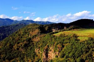
Cangyuan Cliff Painting
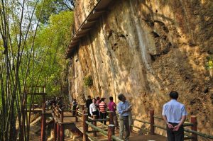
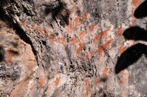
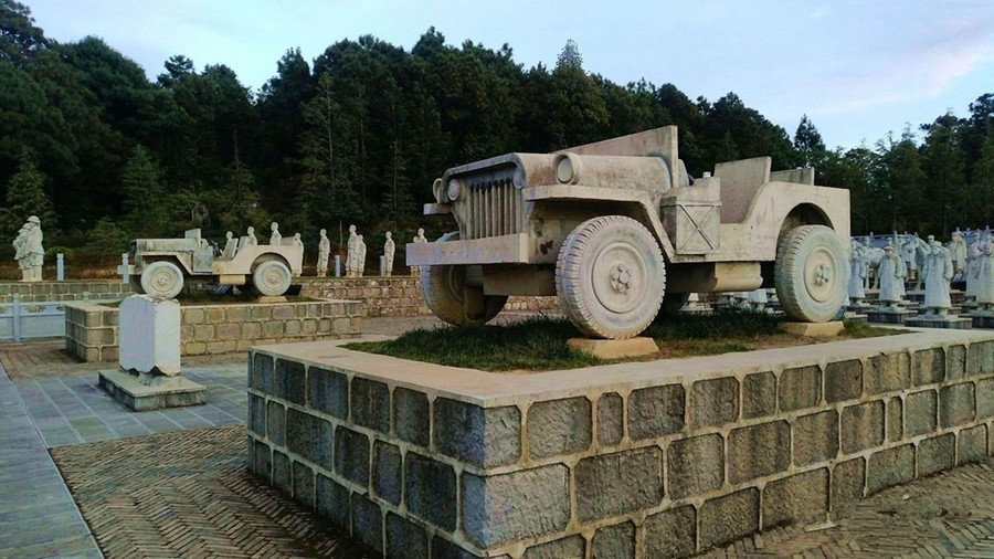
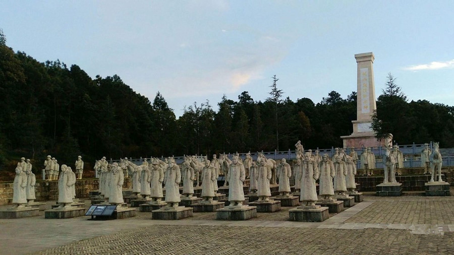
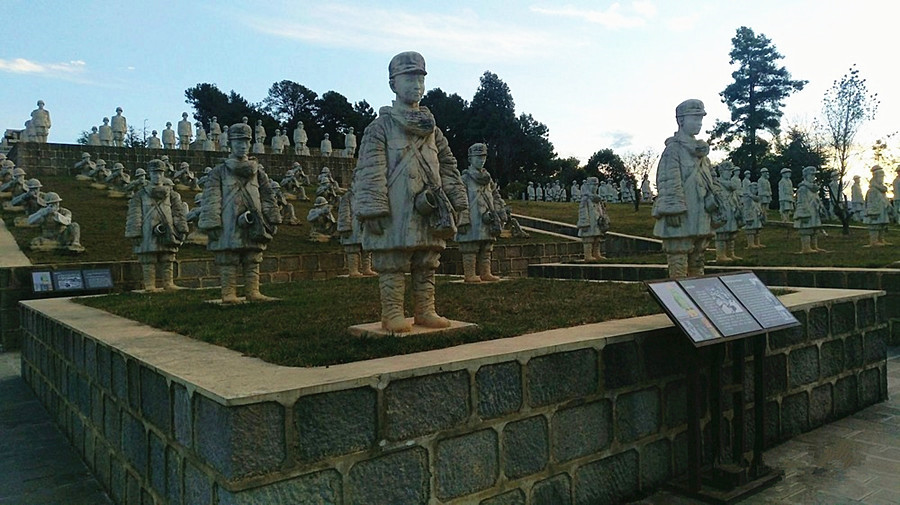
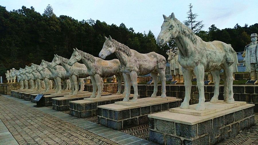
Cangyuan Cliff Painting (沧源岩画), the oldest cliff painting of China, enjoys the history of 3000 years. It is painted with red paint with fingers or feathers. Pigments may be made from animal blood and hematite powder. The cliff paintings mainly describe the hunting activities, production activities and entertainment activities etc. There is also a war triumph, a picture of the bamboo house and the people who hold the weapon and get back with victory. The rough and simple painting is an important material for studying the history of the ancient nationalities of south of China.
Why is Cangyuan Cliff Painting so special?
Cangyuan Cliff Painting is the oldest cliff painting of China, which is the important materials for studying on ancient ethnic groups. Nowadays the paintings have already been designated as the key historical relic protection unit at the provincial and national level. The cliff paintings in Cangyuan County are known for the long history, dense distribution, rich content, complete memorabilia system, and majestic promenade-style cliff-like pictures.
How to get to Cangyuan Cliff Painting?
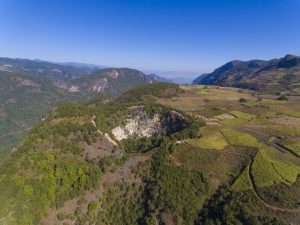
Cliff Painting Valley is a developed place for appreciate cliff painting. It takes about 30 minutes to drive to it from Cangyuan County. Travelers had better to rent a car or drive to it since there is no shuttles.
Introduction
The cliff paintings of Cangyuan is said to take on different colors as the time, weather and humidity change. According to the proverb of the local Wa and Thai people that the cliff painting changes three times a day: in the morning the color is red, at noon lighter and purple in the evening. Nowadays the paintings have already been designated as the key historical relic protection unit at the provincial level.
Up to now, eleven painted cliffs have been found to scatter in the villages of Menglai, Dinglai, Mankan, Heping of Cangyuan County and the village of Mangguang of Dima County etc. Called Randianmu which means the paintings on the rocks in the local Wa language, these reddish brown ancient paintings were basically drawn on the grey limestone at the elevation of about 1, 500 meters. Measuring somewhere between one to thirty square meters, these primitive masterpieces are normally two to ten meters above the ground and include the images of animals, architectures, trees, boats, heavenly bodies like the sun or the moon, mountains and many abstract symbols etc.
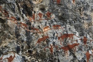
Human figures and lively life scene are also the important themes of these artistic works on the sharp cliffs. The eyes, nose and other facial details of the human face are normally omitted; the painters instead paid more attention to the depiction of the human body and limbs. Apart from artistic meanings and value, many important life activities of these human ancestors such as hunting, dancing, recreation and sacrifice rituals and suchlike are vividly displayed and recorded, which seems to bring the viewers back to those mysterious and remote prehistoric ages.
Purpose of Painting
The creative motives of Cangyuan Cliff painting are not single, and various genres may have different creative purposes. In summary, there are two aspects, religious and the original notes.
Religion Belief
- Witchcraft: People believed that the painting can make their wish come true like the hunting picture giving them the successful hunting.
- Pray for a good harvest: The picture of the flock of herds stands for the wishes for the reproduction of animals. A big party means their celebration for good harvest.
- Worship and Sacrifice: The figures of god and goddess are the symbols of their believes.
Record of Life
- Record of big events: The paintings of the second place are not serious, reflecting the sights of daily life.
- Record of legendary: The legendary carries on their best wishes to life.
Recommended Tours
1 Day Cangyuan Wa Ethnic Culture Tour
5 Days Wa Ethnic Minority’s New Rice Festival Tour
Nearby Attractions
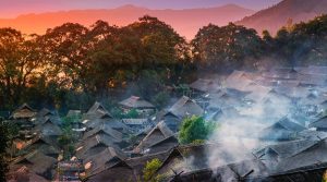
Wengding Wa Ethnic Village
Wengding Wa Ethnic Village(翁丁佤寨) is an over 400 year-old Wa ethic village. Wengding means where the clouds are floating since mists often cloak the mountains throughout the year. People who live there have been called“ the last tribe of China’’,it has preserved the typical style of Wa residential architecture and primitive folk customs. Surrounded by lush trees, the village consists of 98 households with over 400 residence Of Wa people. The local elder stated that the woods protect the safety of the village. Inside of village has the best preserved cottages, totem, the woods, Village pillars and worship places, which reflects the splendid history and culture of Wa people. Black is auspicious color of Wa people. The elder, men and women, prefer holding tobacco pipe when they are free.
Sigangli Cave
Sigangli Cave in Cangyuan (沧源司岗里溶洞) is 3 km from Menglai Village of Cangyuan County. Sigangli means coming from the cave in Wa language. Geological evolvement for numerous years forms plenty of hall in the hole, stalagmites in the hall, stalagnate in different poses and with different expressions, and rich spectacle combination. Some of them seem petty monkey playing around, lion squatting, tiger looking for food etc. Especially, there is a stalagnate, about 20 m high, 1.6 m root thick, standing upright between heaven and land. The stalagnate is small at the upper part but big at the lower part, decorated with stone pattern on it which looks like one by one stone towers, clean and white, acclaimed as the acme of perfection.
Useful Travel Tips
Please take care of yourself when discover the cliff painting.
Do not climb the cliff for appreciating or taking photos.
Protect the cliff painting and do not paint on the cliff.
Why is Yuanjiang River So Special?
Yuanjiang river, the name of the Honghe river in China, is also known as “red river” because of its red sand shale formations and red water. Yuanjiang(Honghe) is divided into two sources, east and west. East source is from Xiangyun county, Yunnan province. West source is positive source, coming from the Maocaoshao茅草哨 at Ailao mountain east foot of Hengduan mountain in Weishan county, Yunnan. When the two sources converge, they are called “Lishe river礼社江”. It is called Yuanjiang River after flowing into Yuanjiang County. Yuanjiang River flows through Chuxiong Yi Autonomous Prefecture, Yuxi, Honghe Hani and Yi Autonomous Prefecture, and then flows into Vietnam from Hekou Yao Autonomous County.
The Yuanjiang river basin is located in 28 cities and prefectures, such as Dali, Chuxiong, Simao, Yuxi, Honghe, Wenshan and Baise(in Guangxi), with a population of about 5.5 million. The main ethnic groups are Han, Yi, Hani, Dai, Bai, Zhuang and Miao.
Branches of Yuanjiang River
Yuanjiang River is the main upstream of the red river, which is located in China. The main branches of the red river, including the Heishui river and Mingjiang river, all originate in China. This part of river in China is called the Yuanjiang river system. With an area of 79,000 square kilometers and an average annual runoff of 48.4 billion cubic meters, Yuanjiang river has a natural drop of 2,519 meters and is rich in water power resources.
The Honghe-Yuanjiang river system has 53 tributaries with a drainage area greater than 100 square kilometers within China, 17 tributaries with an area greater than 1,000 square kilometers and 4 tributaries with an area greater than 5,000 square kilometers. Its main branches include Lixian river李仙江, Tengtiao River藤条江(Mengla river勐拉河), Panlong river盘龙江 and Pumei river普梅河(Nanli river南利河). These four branches form their own independent water systems within the territory of China. After entering Vietnam, they are respectively named Heishui river黑水河, Nanna river难那河, Lujiang river泸江 and Rugui river儒桂河.
Where is Yuanjiang River?
Geographic coordinate of Yuanjiang river basin is between east longitude 100 ° 06 ‘-105 ° 40’ and north latitude 22 ° 27 ‘-25°32’. Located in central and southeast Yunnan province and southwest of Guangxi Zhuang Autonomous Region. It is adjacent to the Jinsha river basin in the north, Lancang river in the west, the Nanpan river basin in the east and Vietnam in the south. The topography of the river basin slopes from northwest to southeast in a narrow bow belt.
Water Resources of Yuanjiang River
The Yuanjiang river is rich in water resources and abundant in runoff, with a total of 48.4 billion cubic meters of water resources in the whole basin, and water yield per unit area 647,ooo cubic meters per square kilometer, which is 2.3 times of the national average water yield. Of the four major rivers in the southwest, it is second only to the Brahmaputra, larger than the Nujiang river and Lancang river. The spatial and temporal distribution of water resources in the Yuanjiang river basin is uneven. The water amount in the rainy season from May to October accounts for more than 85% of the annual water amount, while the precipitation amount in the dry season from December to April only accounts for 10% to 15% of the annual water amount. Therefore, the river runoff in winter and spring is mainly supplied by groundwater.
The Development of Water Resources
Yuanjiang is rich in water resources, but it has a very low level of development and utilization, accounting for only 1% of the total water resources of 48.4 billion cubic meters in the whole basin. It is mainly used for farmland irrigation, urban living water and industrial water supply.
Nearby Attractions
1. Nanuo Terrace那诺梯田
Yuanjiang Rice Terraces are mainly concentrated in Yangjie羊街 and Nanuo那诺, among which Nanuo terrace is the most spectacular. The Nanuo terraces reflect the Hani people’s ancient farming culture.
2. Nanuo Market那诺集市
Nanuo is famous for its Sea of Cloud of terraces and Hani culture in central Yunnan. Nano market is on the double day, there are many Hani people, young and old, but more women. There are exchanges of various items, such as chicken and duck, farm goods, mountain goods, meat, vegetables, sugar cane, piglets and department stores, as well as dyed fabrics and colorful ethnic ornaments.
3. Yuanjiang River National Nature Reserve元江国家级自然保护区
With a total area of 22378.9 hectares, main protected objects in Yuanjiang River National Nature Reserve are the most typical river-valley savanna vegetation, relatively complete mountain evergreen broad-leaved forest and abundant rare wildlife resources. it belongs to the forest ecosystem nature reserve. Nature reserve consists of two sections, namely, the east bank of Yuanjiang (Jiangdong District江东片区 for short) and Zhangba District章巴片区.
How to Get There
1. By Train
Kunming Station-Yuxi Station
Departure Time: 5:36, 7:45, 11:02, 12:30, 15:41, 17:20
Ticket Price: 16.5 CNY
Distance: About 107 kilometers
Consume Time: About 1 hour 15 minutes
Kunming South Station-Yuxi Station
Departure Time: 8:10, 9:55, 10:07, 18:47, 19:13
Ticket Price: 32 CNY or 40 CNY
Distance: About 81 kilometers
Consume Time: About 30 minutes
2. By Long-distance Bus
There are non-stop long-distance bus from Kunming to Yuanjiang.
Kunming South Bus Station-Yuanjiang Bus Terminal
Departure Time: 9:00, 12:00, 15:20, 16:30, 18:00, 17:30
Ticket Price: 79 CNY or 90 CNY
Distance: About 230 kilometers
Consume Time: About 3 hours
Best Time to Visit
Although different seasons have their unique scenary for people to choose in Yuxi and Honghe, in order to avoid rainy summer and protect from the possible natural disaster, the best time to visit in winter with clear weather and warm temperature.
Accommodation at Yuanjiang River
Most of the hotels in Yuanjiang are concentrated in the county seat of Lijiang Subdistrict. Besides, there are hotels in Nanuo Township, which can meet your tour’s need. It is better to stay in these places to have a deep experience of the folk customs and culture of the Yuanjiang.
1. Yuanjiang Hotel元江大酒店
Address: No.2, Hongqi Road, Lijiang Subdistrict, Yuanjiang County, Yuxi玉溪市元江县澧江街道红旗路2号
Tel: 0877-6012888
Starting Price: 185 CNY
2. Yuanjiang Youjia Hotel元江优家酒店
Address: No.118, Wenhua Road, Yuanjiang County, Yuxi玉溪市元江县文化路118号
Tel: 0877-6559900
Starting Price: 58 CNY
Useful Travel Tips
▪ Respect the customs of ethnic minorities and avoid disturbing the lives of local people.
▪ From June to October is the rainy season and the road conditions could be dangerous.
▪ The weather is changeable in the mountains, so bring warm clothes.
Why is First Bend of Nujiang River So Special?
When flowing near Ridan village of Bingzhongluo in Gongshan County, the river encircles a small area of land while turning 180 degrees in only a few hundred meters, with beautiful high cliffs providing a vantage point for sightseers. The river surface has an elevation of 1710 meters above sea level, having a relative fall over 1000 meters comparing with the mountains along the banks of the river, looking from above, the N0 1 turn of the Nu River presents a U-shaped arc with steep terrain and extraordinarily magnificent scene, the whole scenario has a thunderbolt momentum and is nominated as a national level grade 1 attraction. There is a village in the middle of the Bay called Kantong village.
How is the First Bend of Nujiang River formed?
Originally the Nu River winds down the mountains and valleys of Qinghai-Tibet Plateau from north to south, whereas when the Nu River flows near the Ridan village of Bingzhongluo Township, due to the barrier of the cliffs, the course of the river shifts from north-south to east-west direction, after the outflow of more than 300 meters, the river path is blocked by Danla Mountain, the river has to make a sharp U-turn from west to east again, forming an arc-shaped semi-circular path from north to west and then to south. Thus, the Nu River has to change its course for three times, forming three interconnected abrupt turns, therefore it becomes the No.1 turn of the Nu River.
How to Get there
By Bus
There are a few alternatives to get to Nujiang Grand Canyon. From Kunming, one can catch a bus to various places in the Gorge.
Kunming – Fugong:
At least one sleeper bus winding all the way to Fugong in the middle of the gorge. The trip is about 14 hours(710km).
Kuming to Liuku:
It’s 580km. Express and sleeper buses leaving from Kunming daily from 8:00 am to 6:00 pm, 13hrs ride. There are also buses from Dali(8hrs) and Baoshan(4hrs) to Liuku.
Kunming to Gongshan:
A sleeper bus departing from Xiyuan Bus Station at 18:00 daily, 830km/ 18hrs.
Gongshan to Bingzhongluo:
It is about 45km from Gongshan to Bingzhongluo and there are irregular shuttle bus providing the transfer service.
By Car-rental
Renting a car to visit Nujiang Grand Canyon is more convenient. Yunnan Exploration Travel can provide the service for our clients with the good vehicle and skilled driver.
Best Time to Visit
From October to April is the best seasons to visit Nujiang Grand Canyon, especially in the spring time when the mountain flowers are in bloom. During every slack season or on holiday, people here go boating, go overhead cables over the river or sing and dance. The creek, still and soundless, is closed in by trees, hidden from the eyes of men.
Attractions Nearby
Shimen Pass(石门关)
In the north of Bingzhongluo, two cliff straight up along the river bank and form a large stone pass in the height of 500 meters and in the width of 200 meters hence the name ‘Shimen Pass’. Shimen Pass is a stunning landscape lying on a beautiful slope along the river bank. The local people call it ‘Nayiqiang’. It is the essential way to get into Yunnan-Tibet.
Kantong Village(坎桶村)
Kantong village is located in the center of the First Gulf of Nujiang River. It is a little village of Nu people and Kantong means a place of long bamboo. The village is planted with peach trees. Every Spring, the peach blossoms pervade the village so that the local people call it ‘Peach Blossom Island’. There is the only suspension bridge that connects the village to the outside world.
Puhua Temple(普化寺)
Puhua Temple, a Tibetan Buddhist temple, plays an important role in this place. Inside the temple, there are 11 frescoes and 2000 ‘Songji’ in total.
Useful Travel Tips
► Climb to the top of Gongdang Holy Mountain before the shadow of the mountain covering the river water, which is the best time to watch the first bend of Nujiang river. Yangziyuchang(羊脂玉厂) is the best watching spot.
► Qiunatong is a small village surrounded by snow mountains, which cars can not enter into. Walking from Zhongding village to Qiunatong village will cost about 4 hours.
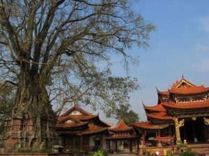
Wengding Wa Ethnic Village
Wengding Wa Ethnic Village(翁丁佤寨) is an over 400 year-old Wa ethic village. Wengding means where the clouds are floating since mists often cloak the mountains throughout the year. People who live there have been called“ the last tribe of China’’,it has preserved the typical style of Wa residential architecture and primitive folk customs. Surrounded by lush trees, the village consists of 98 households with over 400 residence Of Wa people. The local elder stated that the woods protect the safety of the village. Inside of village has the best preserved cottages, totem, the woods, Village pillars and worship places, which reflects the splendid history and culture of Wa people. Black is auspicious color of Wa people. The elder, men and women, prefer holding tobacco pipe when they are free.
Why is Wengding Wa Ethnic Village so special?
Wengding Wa Ethnic Village is one of the best- preserved ancient Wa ethnic communites in China today, also the intangible culture heritage protection unit and historical village of Yunnan Province. The Village was list as the third batch of national famous tourism villages with characteristic landscape by the Ministry of Housing and Urban Rural Development and National Tourism Administration. It is also one of top 10 beautiful village of Lincang City. It is known as the last tribe of China.
Where is Wengding Village?
Wengding Village(翁丁村) , is located in the southwest of Lincang, Yunnan province. It is 17km away from the township government and 39 km from the seat of Cangyuan county.
How to get to Wending Village?
The traffic there is very convenient and the roads to country side are laid with asphalt. It is about 40 km from Cangyuan County. It takes you 1 hour to drive to the Wending Village.
Profile of Wending Village
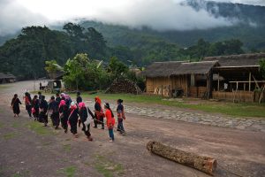
Follow the path to inside of the village, the thatched cottages and the livestock shed are next to each other. Women in Wa national costume weaving cloth in the courtyard, children playing and have fun together. The ox are around everywhere. Talking a Walk to local village’s home, the hospitable villagers will treat you with black tea and dialect. A branch with green leaf hanging in the entrance of the house means that a home born with a new life. You will have a commanding view of the village on the top of the hill ,smoke is curling up from the cottages, everything looks serenity and peaceful.
People beat the drum and sing happily to express their warmly welcome to guest. Wengding Wa Village has been published in the list of national intangible cultural heritage by the people’s Government of Yunnan province in 2006 because of the unique cultural phenomenon in Wengding Wa Village has preserved well. Wengding Wa Village attracts visitors all around the world and also transfer its culture to the rest of world.
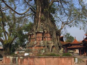
Taking a random walk inside the village, the very first thing comes into your sight is the aged village and tall Banyan trees, guarding the villages for hundreds years. At the same times, you may shocked by the bull head hunging on the village entrance, and it is looks mysterious and amazing.
For centuries, Wengding still remains the railing architectural style, there are two types of cottages: those that single and lonely old people are live in the oval low cottage; those that two –story railing design enable people using the ground floor for feeding livestock and the upper for accommodation. In addition, local villagers will build a storage room without lock near the cottages to keep food. The Wa people believe that the woods besides the village can not be cut for guard the village, so the whole village is surrounded by lush tree.
What to See
Wengding Wa Ethnic Village enjoys the charming landscape and traditional architectures etc. It is a approving place to discover the traditional Wa culture.
Village Pillars and Heart of Village- Pray for Happiness (寨桩寨心 祈愿求福)
Village pillars, the village heart and Sigangli(a wooden stick) are the most mysterious power of the village. The three items stand in the middle of the village and they were believed to be the core of the village. It is a wonderful gathering place with a heavy flavor of life where is suitable for kinds of activities, such as playing ground for children, date for the young, leisure for the elder and worship for local people.
Village pillars, as the core of the village, they believe that as long as you have a sincere heart for pray, your dream will come true. Above the pillars there placed a lot of daily necessities such as crop stick, it is s pray for the rich harvest. From the bottle to top of the pillars, there are 13 layers in total with tripod, iron pot, pot circle and others, which means the reproduction of human beings. There is a bamboo stick and crop-made wreath standing at the highest of the pillar. The wood boat is the source of life in Sigangli tale, the wood bird standing at the boat to help herd and the wood fish swimming under the boat.
There is a public room, 5 m away from village heart, which provide for the young has date and those temporary stopover.
Huotang Culture (火塘)
Huotang, a Chinese style fireplace, is one of holy custom to Wa people. Wa people light the fires in their new home and they will not extinguish the fire. The fire means harmony and prosperity for home and family.
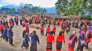
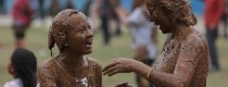
Monihei Carnival (摸你黑节)
“Monihei Carnival” (making you black) is a mud smearing carnival of the Wa ethnic group. It is originated from the folk custom that people smear the pot ash, ox blood and mud on their faces to frighten the evils and seek peace. The Monihei Carnival is held in late April or early May each year in Cangyuan County, one of the only two Chinese Wa autonomous Counties in southwest China’s Yunnan Province.
The activities of the “Monihei Carnival” of Wa ethnic group mainly involve a grand opening ceremony of song and dance performance, ethnic arts tour, a crazy and passionate “making you black” activity with thousand of people’s participation, ancient cliff painting worship, songs about life in Washan Mountain, campfire party and Wa songs concert.
Tourists can use natural paints to smear each other and pray for each other. “Monihei Carnival” has attracted more and more tourists both from home and abroad to join the activity.
Recommended Tours
1 Day Cangyuan Wa Ethnic Culture Tour
4 Days Cangyuan Wa Ethnic Minority Discovery Tour
4 Days Cangyuan Monihei Carnival Tour
5 Days Wa Ethnic Minority’s New Rice Festival Tour
Nearby Attractions
Cangyuan Cliff Painting
Cangyuan Cliff Painting (沧源岩画), the oldest cliff painting of China, enjoys the history of 3000 years. It is painted with red paint with fingers or feathers. Pigments may be made from animal blood and hematite powder. The cliff paintings mainly describe the hunting activities, production activities and entertainment activities etc. There is also a war triumph, a picture of the bamboo house and the people who hold the weapon and get back with victory. The rough and simple painting is an important material for studying the history of the ancient nationalities of south of China.
Useful Travel Tips
1. Best time to visit: Travelers can visit the Wengding Wa Ethnic Village during April 29 to May 1, you can enjoy the local carnival in this period and discover more traditional culture.
2. Acoommodation: Travelers can accommodate at the home of villagers. It is relative cheap to eat and stay in their home.
3. Respect the local custom of Wa people, especially their believes.
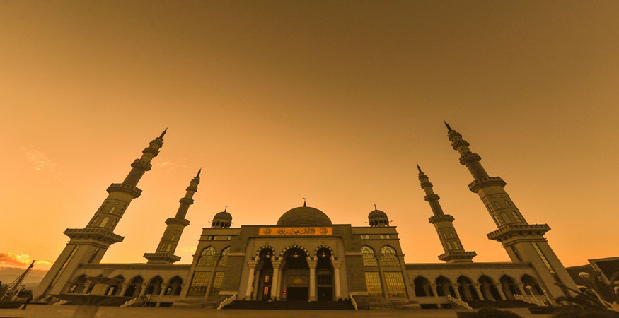
Introduction of Shadian Grand Mosque
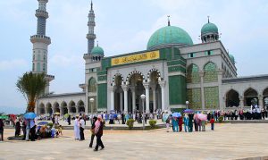
Grand Mosque of Shadian was originally built in the year of 1684. After several restorations and reconstructions, the new Grand Mosque of Shadian is built into a large-scaled mosque with a construction area of 18,000 square meters. It is able to hold a capacity of 10,000 people to do prayers at a time.
Grand Mosque of Shadian is consisted by main buildings of prayer hall, vault and four minarets. This grand mosque has inherited the decoration style for its galleries, arches and pillars from Nabawi Mosque in Medina, Saudi Arabia. What attracts most of this mosque is its grand vault which has an inner diameter of 20 meters and a height of 42 meters. In the middle of the vault there is a large dome surrounded by four small domes in the four directions, while at the top of the dome there featured an Islamic styled crescent.
Attractions in Shadian Grand Mosque
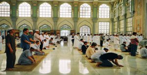
Four Minarets
There are four magnificent minarets standing in the four corners of the mosque. They are splendid to have a height of 93 meters. The intricateness of this mosque also lies in the characteristic that there are gorgeous arched galleries to connect the prayer hall, domes and minarets, which makes the three parts an integral combination. The hall of the mosque is decorated with stone carved Quran and golden decorations. The eight huge pillars inside the hall are veneered with marble materials. Grand Mosque of Shadian is a main place for Muslims in the area and it is a famous and must see Muslim attraction when for a Muslim tour in Yunnan Province.
Grand Mosque
Grand Mosque of Shadian was originally built in the year of 1684. After several restorations and reconstructions, the new Grand Mosque of Shadian is built into a large-scaled mosque with a construction area of 18,000 square meters. It is able to hold a capacity of 10,000 people to do prayers at a time.
Grand Mosque of Shadian is consisted by main buildings of prayer hall, vault and four minarets. This grand mosque has inherited the decoration style for its galleries, arches and pillars from Nabawi Mosque in Medina, Saudi Arabia. What attracts most of this mosque is its grand vault which has an inner diameter of 20 meters and a height of 42 meters. In the middle of the vault there is a large dome surrounded by four small domes in the four directions, while at the top of the dome there featured an Islamic styled crescent.
Characteristics of Architectural Style
Shadian Grand Mosque architecture belongs to elegant style. Hui people have a rich life, be faithful to the teachings of Islam. There is A rich atmosphere of religious etiquette. Part of the inheritance of traditional Chinese architecture. The mosque is symmetrical along the axis and consists of the main hall, the minarets, and the lecture hall.
How to Get there?
You have two ways to get to Gejiu, long-distance bus and train. As for airplane, it is not available up to now.
1. By Long-distance Bus
There are 11 non-stop buses a day from Kunming East Station to Gejiu Bus Terminal. Here below are main bus terminals in Gejiu City.
a. Gejiu Bus Terminal (个旧汽车客运站)
Address: No.4, Gejin Road, Gejiu City
Tel: 0873-2132982
2. Xinguan Bus Terminal (新冠客运站)
Address: No.90, Xinguan Road, Gejiu City
3. Datun Bus Terminal (大屯客运站)
Address: No.62, Kunhe Road, Datun Town, Gejiu
Kunming-Gejiu
Price: 117 CNY
Departure Time: 8:30, 10:00, 11:00, 11:45, 12:15, 13:50, 14:20, 15:30, 17:15, 18:15, 20:00
Distance: 279 kilometers
Consume Time: about 4 hours
Tips: The price and time are for reference only, specific with actual condition. More prices and departure time, you can ask for details at bus terminals.
2. By Railway
Gejiu Station was out of service for a very long time. Therefore, there is no railway station now in Gejiu, you can’t reach to Gejiu directly by train. If you want to take train, you are suggested to transfer in Mengzi City.
Kunming Station-Mnegzi North Station-Gejiu
You will spend about 3 hour and a half on the train from Kunming to Mengzi, then around 0.5 hour from Mengzi to Gejiu. The starting price of train ticket is 40.5 CNY. Every day, there are at least 4 trains from Kunming to Mengzi.
3. By Air
At present, there is no airport in Gejiu, you can’t go to Gejiu by plane. Mengzi airport, Mile airport, Yuanyang airport and Luxi airport in Hong Prefecture are under plan and construction. In the near future, you may spend less time on the way to Gejiu.
If you Plan to Gejiu and want to book tickets, please contract us.
Photo Number: +86-871-63511469
Email Address: contact@YunnanExploration.com
Recommended Tour Routes
Touring with us will make your time well-spent well spent and your trip in Shadian Grand Mosque with a unique experience. Join us in the following tours:
6 Days Kunming Shadian Muslim Tour with Yuanyang Rice Terraces and Jianshui Old Town
7 Days Yunnan Muslim Culture Tour with Shadian Mosque and Yuanyang Rice Terraces
13 Days Yunnan Muslim Culture Discovery Tour
Travel tips
1. The mosque is free to visit.
2. Take off your shoes before you come in.
3. Ladies should wear headscarves when she comes in Shadian Grand Mosque.
4. Non-Muslims can’t enter the hall.
Why is Menghuan Golden Pagoda So Special
It’s the best place to have a bird-eye view of Mangshi and those picturesque Dai villages around. Being 73 meters high, the pagoda is a three-storied octagonal but hollow one. The ground floor is the most impressive. With an area of 2,000 square meters, it’s spacious enough for nearly 2,000 pilgrims to pray at the same time. Enshrining in the hall are mainly Buddhist figures, such as Sakyamuni in the east, Guanyin (Goddess of Mercy) in the south, Medicine Buddha in the west, and Maitreya (the Future Buddha) in the north, etc. all of which are made from Myanmar white marble to present grandeur and magnificence. Menghuan Golden Pagoda was started from June 30, 2004 and completed in June, 2007. The whole frame is eight-square hollow pagoda, opened with four gates. In the middle of the audience hall, circling the peak columns is four statues of Buddha made by natural white marble. The Menghuan Golden Pagoda is the first golden pagoda in China and the first hollow pagoda in Asia.
Where is Menghuan Golden Pagoda-Location
Menghuan Golden Pagoda is located at Leiyarang Mountain in the southeast of Luxi City(Mangshi), the capital city of Dehong Prefecture.
How to Get Menghuan Golden Pagoda
Visitors shall come to the foot of the Leiyarang Mountain by taxi, then get to the top of the Leiyarang Mountain on foot.
Best Time to Go
The best time to visit Menghuan Silver Pagoda is from October to April of following year.
Other Unique Pagodas in Yunnan
Nearby Attractions
Menghuan Silver Pagoda
he Menghuan Silver Pagoda is located on the top of Leiyarang Mountain, southeast of Mangshi, at an altitude of 1,079.6 meters.Legend has it that “Sakyamuni” lived here when he was reincarnate as a golden pheasant. After hundreds of years the Nirvana of the Sakyamuni, in order to spread the doctrines of Buddhism, his disciples “Zhaohanda” made practices in the mountain. In order to make a better environment to make practices for “Zhaohanda”, all the weeds and the thorns get out of the way, so it is called the Leiyarang Mountain, which means the place where the weeds get out of the way. Later, a pagoda was built in this mountain. It has been recognized as one of the Buddhist holy places since ancient times.
Tours Including Menghuan Golden Pagoda
- 4 Days Jingpo Ethnic Minority’s Munao Zongge Festival Tour
- 11 Days Western Yunnan and Myanmar Border Cycling Tour
- 15 Days China Ledo Road Study Tour
- 39 Days Yunnan 25 Ethnic Minorities Discovery and Photography Tour
Useful Travel Tips
- Tourists are not allowed to touch the statues of Buddhas to show your respect.
Why is Tree-Wrapped Pagoda and Pagoda-Wrapped Tree So Special
The Pagoda Wrapped in the Tree is miraculous and unique. Its body is like an arhat standing with a stately air. A grand bodhi tree protects the top of the Tower like a huge opening umbrella. The thickset crown reaches up to the sky like arms. The bronze-coloured trunk twists and wraps the body of the Padoda tightly. Leaves and branches reach down and water the foundation of the Pagoda like a waterfall. The tree wraps the Pagoda and the Pagoda embraces the tree. They depend on each other for existence, and therefore form a marvellous spectacle known throughout west Yunnan and southeast Asia.
Where is Tree-Wrapped Pagoda and Pagoda-Wrapped Tree-Location
It is located in East Side of Middle Section of Tourism Pedestrian Street, Youyi Road, Mangshi Town(芒市镇友谊路旅游步行街中段东侧)
How to Get to Tree-Wrapped Pagoda and Pagoda-Wrapped Tree
For it is in the downtown of Mangshi, visitors can walk or take a taxi which will cost you 5 yuan.
History of Tree-Wrapped Pagoda and Pagoda-Wrapped Tree
The 15th tusi (native chieftain) built the Jielie Stupa to remember a triumph. It is said that there was a God sprinkling a piece of seed into the stupa. After 200 years, this seed amazingly grow into a tall banyan tree. Therefore, the rare view “Tree-wrapped pagoda and Tower-wrapped Tree” comes into being. The Tree-wrapped pagoda and Tower-wrapped Tree was formerly called Tiecheng Pagoda. The pagoda is a solid tower made of bricks. It is wrapped and covered by tree roots, and is thus called Tree-wrapped pagoda and Tower-wrapped Tree. It is the earliest pagoda built by local Dai people.
Legend of Tree-Wrapped Pagoda and Pagoda-Wrapped Tree
One disciple of Sakyamuni asked him, “ How can we express our true piety for you?” Sakyamuni thought for a while, spread his gown on the ground, put his begging bowl upside down on the gown, and placed his buddhist wand on the bowl. His disciples were suddenly enlightened. Later, the gown became the square foundation of the pagoda, the bowl became the body of the pagoda and the wand, the top of the tower. This is how the Pagoda-wrapped Tree came into being.
Best Time to Go
It is warm here in winter. So winter (the dry season) is a perfect season to visit there, but Dehong’s scenery is attractive all year round.
Nearby Attractions
Menghuan Golden Pagoda
Menghuan Grand Golden Pagoda is located at Leiyarang Mountain in the southeast of Luxi (Mangshi), the capital city of Dehong Prefecture. It’s the best place to bird-eye view the town of Mangshi and those picturesque Dai villages around. Being 73 meters high, the pagoda is a three-storied octagonal but hollow one. The ground floor is the most impressive. With an area of 2,000 square meters, it’s spacious enough for nearly 2,000 pilgrims to pray at the same time. Enshrined in the hall are mainly Buddhist figures such as Sakyamuni in the east, Guanyin (Goddess of Mercy) in the south, Medicine Buddha in the west, and Maitreya (the Future Buddha) in the north, etc. all of which are made from Myanmar white marble to present grandeur and magnificence.
Menghuan Silver Pagoda
he Menghuan Silver Pagoda is located on the top of Leiyarang Mountain, southeast of Mangshi, at an altitude of 1,079.6 meters.Legend has it that “Sakyamuni” lived here when he was reincarnate as a golden pheasant. After hundreds of years the Nirvana of the Sakyamuni, in order to spread the doctrines of Buddhism, his disciples “Zhaohanda” made practices in the mountain. In order to make a better environment to make practices for “Zhaohanda”, all the weeds and the thorns get out of the way, so it is called the Leiyarang Mountain, which means the place where the weeds get out of the way. Later, a pagoda was built in this mountain. It has been recognized as one of the Buddhist holy places since ancient times.
Travel Tips:
- Climate: The region enjoys a subtropical monsoonal climate without winter chills nor intense summer heat. It has clear dry and humid seasons, with good rainfall. Its annual average temperature is around 18-20℃ (64.4-68℉). Temperatures vary greatly during the day, and it can reach 25℃ (77℉) in daytime during winter.
- Tourists are not allowed to touch the statues of Buddhas to show your respect.
Why is Jiegao Border So Special
“Jiegao” is a Dai Language, meaning “the old town”. It is said that Sinan King of Luchuan built his capital here in the late Yuan Dynasty or the early Ming Dynasty. Thus the town got such a name. During the Anti-Japanese War, Jiegao was a very prosperous town. American planes frequently came here, carrying military supplies. It lies 4 kilometers away from Ruili, and is the only part of Ruili Town on the southeastern bank of the Ruili River, known as “shatoujiao” or “Tianyahaijiao” in the southwest of China.
Where is Jiegao Border-Location
It is located in the downtown of Ruili about 4 km southeast of the Ruili River, with a total area of 2.4 square kilometers closely linked to the state level port—Mujie(Muse) of Myanmar in the East, south and north.
How to Get to Jiegao Border
- It is convenient to get to Jiegao Border by chartering cars at the price of 300-500RMB, which includes some attractions, such as, Jielei Golden Pagoda, One-Tree Forest and Moli Tropical Rainforest.
- It is convenient to take No. 3 Bus to get to Jiegao Border.
- There are a lot of taxis to go to Jiegao Border in Ruili City. It is about 20 RMB by taxi. It will be cheaper to share a car with other at the price of 5 RMB.
History of Jiegao Border
During the Anti-Japanese War, a temporary airport was built here and there were very often takeoffs and landings of the U.S. aircrafts delivering munitions and supplies. It is located in the downtown of Ruili about 4 km southeast of the Ruili River, with a total area of 2.4 square kilometers closely linked to the state level port—Mujie(Muse) of Myanmar in the East, south and north.
In 1987 Jiegao became an important port where bilateral trade could be done. In 1991, “Jiegao Border Trade Economic Zone” was set up. China and Burma have built China-Burma Street, which is now filled with stores and shops. Since 1992 the imports and exports from Jiegao have accounted for 50% to 60% of the total imports and exports of the border trade of the province, and over 30% of the imports and exports of the border trade from the inland ports throughout the country. Jiegao Bridge across the Ruili River links Ruili with Jiegao. The bridge is now the longest road bridge in Yunnan and on the boundary line in the Southwest of China. In a word, the booming Jiegao has become a newly- developing business town and border resort with typical ethnic features and modern facilities.
Best Time to Go
Spring and fall are the best time to visit Jiegao Border.
Nearby Attractions
One-Tree Forest
In fact, One-Tree Forest is a large banyan tree, which has a history of more than 900 years, with 32 earial roots streight pinning into the earth. Banyan is a special and unique landscape in Ruili, it’s everywhere no matter in the vallies or villages or on the sides of the roads. people value banyan as holy tree, so they only plant these trees but don’t cut them. The big Banyan is in the one-tree forest park, and it’s 28 meters, what makes it more precious is that it has been standing there for over 200 years. The tree has many aerial roots hanging down from above, and they are interwined with one another, ending in the root. there are also so many aerial roots hanging down and they took roots in the earth, forming a forest that makes up of pillar-like roots, thus one-tree forest is shaped. It’s a very attractive and magical natural scenery. One-tree Forest has become a scenery that tourist must go, and it’s one of the hottest sceneries in Ruili.
Zhaduo Waterfall
Moli Waterfall is located in Moli Valley, also called Zhaduo Waterfall, and hides in deep mountains and forest. the clean water falls from 40-meter cliff, it’s like a white silk flying and dancing in the wind, you can hear the falling sound of water far away. There is a small brook flowing under the waterfall. The whole part of the waterfall is the soul of the scenic area, it’s very enjoyable to watch and feel the waterfall in the morning when the sun rises. It’s also very worthy to go there in summer, you can feel splashes from the waterfall and splash on your face, it’s very nice and cool.
Moli Tropical Rainforest
Moli Tropical Rainforest, is known as its tropical rainforest view and Buddhist holy land, the whole scenic area is 1.5 kilometers long. Moli, also known as Zhaduo, refers to a grand waterfall. Moli is known as a natural oxygen bar, which is healthy for people.
Tours Including Jiegao Border
11 Days Western Yunnan and Myanmar Border Cycling Tour
4 Days Jingpo Ethnic Minority’s Munao Zongge Festival Tour
39 Days Yunnan 25 Ethnic Minorities Discovery and Photography Tour
Why is Moli Tropical Rainforest So Special
Moli Tropical Rainforest, is known as its tropical rainforest view and Buddhist holy land, the whole scenic area is 1.5 kilometers long. Moli, also known as Zhaduo, refers to a grand waterfall. Moli is known as a natural oxygen bar, which is healthy for people.
Where is Moli Tropical Rainforest-Location
Located 20 kilometers northeast of Ruili City, Moli Tropical Rainforest Scenic Area is a tropical rainforest scenic spot that integrates tropical rainforest, religious holy land and holiday paradise. The Moli Scenic Area preserves dozens of rare plants, such as Ficus Virens, Chinese Banyan, the “forest demon” strangled vine, the tree fern with the reputation of “the billions of years of living fossils” and other rare plants.
How to Get to Moli Tropical Rainforest
It is inconvenient to take a bus to get to Moli Tropical Rainforest. Because it is approximately 5-6 kilometers away after getting off the bus. Therefore, it is a best choice to charter a car to Moli with the price of 50 RMB for single way.
Best Time to Go
Spring and fall are the best time to visit Moli Tropical Rainforest, because the air is moist, which makes people very comfortable.
Nearby Attractions
Zhaduo Waterfall
Moli Waterfall is located in Moli Valley, also called Zhaduo Waterfall, and hides in deep mountains and forest. the clean water falls from 40-meter cliff, it’s like a white silk flying and dancing in the wind, you can hear the falling sound of water far away. There is a small brook flowing under the waterfall. The whole part of the waterfall is the soul of the scenic area, it’s very enjoyable to watch and feel the waterfall in the morning when the sun rises. It’s also very worthy to go there in summer, you can feel splashes from the waterfall and splash on your face, it’s very nice and cool.
One-Tree Forest
In fact, One-Tree Forest is a large banyan tree, which has a history of more than 900 years, with 32 earial roots streight pinning into the earth. Banyan is a special and unique landscape in Ruili, it’s everywhere no matter in the vallies or villages or on the sides of the roads. people value banyan as holy tree, so they only plant these trees but don’t cut them. The big Banyan is in the one-tree forest park, and it’s 28 meters, what makes it more precious is that it has been standing there for over 200 years. The tree has many aerial roots hanging down from above, and they are interwined with one another, ending in the root. there are also so many aerial roots hanging down and they took roots in the earth, forming a forest that makes up of pillar-like roots, thus one-tree forest is shaped. It’s a very attractive and magical natural scenery. One-tree Forest has become a scenery that tourist must go, and it’s one of the hottest sceneries in Ruili.
Tours Including Moli Tropical Rainforest
39 Days Yunnan 25 Ethnic Minorities Discovery and Photography Tour
22 days Yunnan Birds Watching Tour
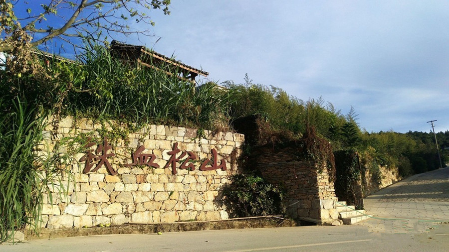
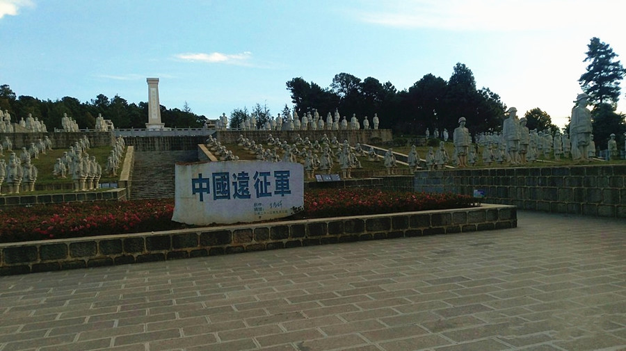
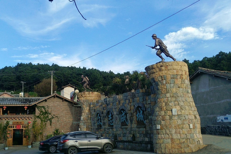
Chinese Name:龙陵县松山
English Name: Songshan Mountain in Longling County, Baoshan
Why is Blue Moon Valley so special?
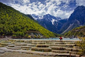
Blue Moon Valley is a popular spot inside the Jade Dragon Snow Mountain Scenic Area, nine miles (15 kilometers) away from Lijiang Old Town. Located besides the Spruce Plateau (Yunshanping云杉坪),the east side of the Jade Dragon Snow Mountain, Lijiang , the Blue Valley looks just like a hanging waterfall from the heaven. It is fed by the melting snow and ice running down from the Jade Dragon Snow Mountain. The water is freezing. Even in summer, visitors cannot bear the piercing cold when they dabble in the river. Seen from a distance, it resembles a blue crescent moon inlaid at the foot of the mountain.
However, blue is not the only color of the river. The river is extremely clear and clean without any pollution. The river bed consists from the white marbles and limestone gravels. If it rains, the white mud and limestone rubble at the riverbed will be swirled up, making the water as white as milk. Therefore, local Naxi people name it White Water River (Baishuihe River).
Where is Blue Moon Valley?
Blue Moon Valley, or Baishui River, is located nearby Yunshanping (cable car) and Ganhaizi, at the eastern foot of Jade Dragon Snow Mountain, approximately 30km (18.6 miles) north of Lijiang Ancient Town. The river was formed by the streams melted from the glaciers and snow of Jade Dragon Snow Mountain. The riverbed is made up of off-white crushed limestone and marbles, making the water look white, hence the name.
How to get to Blue Moon Valley
Step 1, visitors can take a taxi, or the regular bus or city bus No.7 to get to Jade Dragon Mountain Scenic Area
Step 2, walk or take a battery car to the White Water River area.
Blue Moon Valley is a popular spot inside the Jade Dragon Snow Mountain Scenic Area, 15 kilometers (9 miles) away from Lijiang Old Town. You can either take a through bus or charter a minibus to get to the Snow Mountain first.
Take a through bus at Yuhe Parking Lot near the northern gate of Lijiang Old Down. You can buy the ticket in Tourist Service Center at the northern end of Lanhua Street, opposite Tianyu Hotel. The bus leaves for the Snow Mountain at 8:30 and returns at 16:30; the bus fare costs CNY40 per person.
Jade Dragon Snow Mountain is 22 kilometers (14 miles) away from Lijiang Old Town. You can charter a minibus at a charge of CNY200~300 for a round-trip; a one-way trip should take around 40 minutes.
Upon arrival, take a sightseeing bus at the visitors’ center near the gate of the scenic area to the valley; the fare is CNY20. Other spots inside like Spruce Plateau, Yak Plateau, and Glacier Park Cable Car Terminus can also be accessed by sightseeing bus.
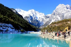
What to See in Blue Moon Valley?
It is said that the water in Baishuihe River is a sacred place of love. When two Naxi teenagers fall in love with each other, the boy will stand barefoot in the cold river in winter to test his love to the girl. It is believed that their love will be tested and last forever in the holy mountain.
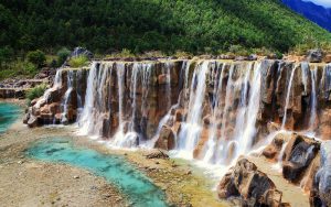
There are four lakes divided by small waterfalls or giant rocks along the river, namely Jade-Like Lake, Mirror Pond, Blue Moon Lake, and Wave-Listening Lake. The lakes form a natural mirror reflecting the grand snow mountain, surrounding cliffs, and lush plants. There are small shoals dotted among the water, breaking the smooth surface of the lakes. Travelers can take good pictures anywhere along the river. But the best point is the White Water Terrace on the upstream. It is made up of fan-shaped stairs with the river running down from each step, looking like shining shells under the sunlight.
The White River Terraced Waterfall
White Water River (local people also call it Milk River) is clean, pure and sacred for the local Naxi people. It flows eastward and finally meets the Black Water River, forming the White and Black River in Lijiang. The ancient Dongba scriptures describe that the black and white reinforce each other creating the harmonious, peaceful world. Here visitors can also explore the mysterious caves, waterfalls, lakes, wild flowers…
The White River terraced waterfall is not 100% natural but partly man-made. Still it is really beautiful in white color and unique in crescent shape. Many travelers consider it a smaller version of Pamukale in Turkey. If you visit it in the off-peak season, you can enjoy the delightful serenity and get great shots of the waterfall terraces with the majestic snow mountain as the backdrop, without tourist crowds.
Blue Moon Valley
What attract people most are the beautiful sceneries and breathtaking landscapes of the Blue Moon Valley, the magical and mysterious fairy water, the deep limestone caves, countless of azaleas, and the natural Longkou Waterfalls(龙口水瀑布). American botanist Joseph Rock once made a lot of travelogue here, and left a lot of documents and pictures. The words and pictures inspired the British writer James Hilton so the word Shangri-La can be found in his work, Lost Horizon.
Traveling to the Blue Moon Valley, tourists can not only enjoy the beautiful scenery, but also its unique charm as one of the birthplaces of the Naxi culture.
Attraction Travel Tips
Traveling hours: One day
Traveling seasons: Summer
Ticket price:
Free of charge, the entrance ticket to Jade Dragon Snow Mountain has included the visit to White Water River and Blue Moon Valley.
If taking a battery car around for sightseeing, an additional charge of RMB40 will be applied.
Activities: car sightseeing, walking around
Best time to visit: summer from June to September, when the weather is mild and the various kinds of flowers are in full blossom.
What to Pack: Travel light when strolling in the vally. Bring a camera with you that you can take photos along the way. Sunlight is very strong in Lijiang, wear sun protection such as hats, sunglasses and use sun block, etc.
Photography Tips: To shoot some amazing photos of Blue Moon Valley, photographers should not miss Jade-Like Lake, Mirror Pond, Blue Moon Lake, The White River Terraced Waterfall, Longkou Waterfalls and Wave-Listening Lake. It is better shoot in the early morning and late afternoon.
Others Scenic Area:
Lijiang old Town is officially called “Dayan Town”, “Dayan” literally means a “great ink stab”, a graphic description of the town’s location on a piece of rich flatland fed by a river and surrounded by green mountains. It is a well-preserved Naxi ancient town, listed as UNESCO World Heritage site in 1997. It is one of the four best-preserved ancient cities in China. The unique geographical location, historical background and multiracial inhabitants make it one of the most popular travel destination in China.
Located in Yulong Naxi Autonomous County, Lijiang City, Yunnan Province, Jade Dragon Snow Mountain is 15 kilometers north of the downtown, which has a highest altitude of 5596 meters and an area of 455 square kilometers. With thirteen perennial snow peak, Jade Dragon Snow Mountain resembles a jade dragon lying in the clouds, hence the name. Featured by its magnificence, precipitousness, uniqueness and beauty, the scenery of Jade Dragon Snow Mountain changes in accordance with seasons and weathers.
Nestled at the foot of Jade Dragon Snow Mountain, 6 km northwest of Lijiang old town, Shuhe Old Town was once a staging post at ancient Tea & Horse Road. With an altitude of 2440 meters above sea level, it is a tranquil town with a population of about 3000 people. Along with its sister town Lijiang, it is also part of the UNESCO Heritage site. Shuhe is the earliest settlement of Naxi people in Lijiang when their ancestors first moved to this region.
Baisha Old Town is one of the oldest towns in Lijiang City. It got its name “Baisha” meaning “white sand” from the natural white sand in the area. It was the cradle-land of the Tusi Dynasty evolved from the Mu Clan. It was also the earliest settlement of the Naxi people. In ancient times, Baisha was a center of silk embroidery in southwest China and an important place on the Ancient Tea and Horse Road.
Chinese Name: 沧源天坑
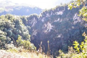
English Name: Tiankeng Dolines in Cangyuan County
Keywords: Tiankeng Dolines in Cangyuan,Cangyuan attractions, Cangyuan tours, karst landform
Location: These Tiankeng Dolines are located at the middle of the Cliff Painting Valley in Cangyuan
Admission Fee: Free
Opening Hours: All the day
Tiankeng Dolines in Cangyuan County
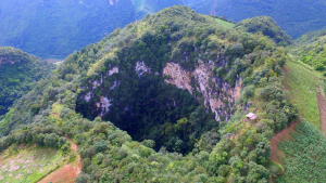
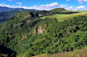
Tiankeng is called funnel karst landform in geography, Tiankeng Dolines in Cangyuan County is the biggest one in Yunnan province. Tiankeng Group of Cangyuan County in China is a large, steep-walled, pit-like, negative, karst landform that opened from beneath towards surface, with both its depth and its diameter more than 100 m to several hundred meters, developed in a great thickness of continuous soluble rocks within the aquifer vadose zone above deeply buried water table and connecting with an active cave river at its foot. It is also characterized by its tourism values of rarity, grandeur and spectacular magnificence, and by its special ecological environment.Apart from this biggest one in front of us, there are other 6 tiankeng lie in same level line. It was said that once a man climbed down the cliff, seeing an unfathomable cave. Inside the cave there are lakes, waterfall and a great number of stalactites.
What is Doline or Tiankeng?
A doline, sink or sinkhole is a closed depression draining underground in karst areas. It can be cylindrical, conical, bowl- or dish-shaped. The diametre ranges from a few to many hundreds of meters. There are two different mechanisms for the forming of dolines:
Solution
The corrosive solution of limestone by rainwater is very high in the area fo crack, allowing the water to run into the rock. This normally forms the bowlshaped type of dolines.
The solution produces large amouts of clay (depending on the pureness of the limestone). This clay is water resistant and sometimes plugs the drainage, so little lakes of rain water can sometimes be found in dolines, a rare thing in waterless karst areas.
Collapse
When a cave grows, there may be a point where the roof of a cavern is not stable enough. This results in (several) collapses that shape the roof like a dome. This process runs out, when the shape is able to hold the weight of overlying rocks.
If the impact of this collapse reaches the surface, if the overlying layers are too thin then the ceiling collapses and a doline is formed. The doline is often a natural entrance to the cave.
Discoveries of Karst Tiankengs in China
Karst tiankengs have been known as “large collapse dolines” for a long time, since small number of them have been discovered around the world, but they have received little attention in academic research. In China, the large collapse dolines that were first widely known are in Sichuan Province. Then more such dolines were reported in Guangxi Province, mostly as marvelous natural scenery. From early 90s up to now, a series of karst tiankengs were found and studied in China by Sino-foreign cave expeditions and other many research projects sponsored by Geological Society of China and Institute of Karst Geology of the Chinese Academy of Geological Science. It is during this period of extensive research that the name “karst tiankeng” is formally proposed and widely recognized as the right terminology for this unique geological formation.
There are about 50 karst tiankengs known in China. Of these, 3 are giant tiankengs more than 500 m deep and 500 m in entrance diameter – Xiaozhai Tiankeng in Fengjie of Sichuan, Dashiwei Tiankeng in Leye of Guangxi and Haolong Tiankeng in Bama of Guangxi. There are also 5 large tiankengs more than 300 m in depth and entrance diameter.
Distinction between karst dolines and karst tiankengs
Karst doline is one of the most familiar and distinctive landforms in karst terrains. There are several doline types that form in the soluble rocks, including the corrosion doline, the permeable doline, the suffosion doline and the collapse doline. Of collapse dolines, there are karst bedrock collapses and also collapses in insoluble rock that covers a buried karst, but the size of all these do not match the size of a tiankeng. To date, dolines found in carbonate rocks have diameters and depths up to about 100 m. Steep-walled, pit platform is different from all the main doline types, they differ not only in size but also in their development mechanisms and conditions. Why is a large karst doline now named as a karst tiankeng? The basic reasons are:
A tainkeng develops in special environmental conditions that integrates aspects of geology, geomorphology and hydrogeology, but a common doline develops in a much wider range of karst environments. Consequently, dolines and collapse dolines are widespread while karst tiankengs are very few within the global picture of karst.
A tiankeng differs greatly from dolines and collapse dolines in its development and erosion mechanisms. The common collapse doline forms by dissolution and suffosion in normal geological and hydrodynamic environments. Collapse tiankengs have developed through an unusual hydrodynamic combination of erosion, dissolution and collapse where three evolutionary stages may be distinguished – from a cave river to an underground cavern to a tiankeng open to the surface – this is not comparable.
A tiankeng is very different from a normal doline in size. It is very large and broad.
Tiankeng have close relationships with the regional development of cave river systems, and their distribution, evolution, age and development rates are not comparable to those of common karst dolines.
Genetic Types and main features of karst tiankengs
Current research suggests that tiankengs developed in carbonate rocks may be divided into two types-collapse tiankengs and erosional tiankengs. The former is much more widespread and numerous than the latter.
Collapse tiankengs
Collapse tiankengs formed in soluble rocks in which massive amounts of rock material were dissolved and eroded away at depth by an intensely dynamic underground drainage system, notably by large cave river system. Under specific geologic and hydrogeological conditions, a cavern evolved as its roof failed gradually while the falling rock debris was carried away by water, until it opened to the ground surface.
Erosional tiankengs
Erosional tiankengs developed in the vadose zone of soluble rocks by allogenic water eroding and dissolving the rock in its vertical descent from the surface. They are very rare because of their special environmental conditions.
Collapse and erosional tiankengs have some features basically in common, but also have some important differences in their development conditions:
A great and continuous thickness of soluble rocks
Solution sedimentary rock (generally carbonate rocks in China) is the first requirement for tiankeng development. Clearly, large and deep tiankengs developed within large thickness of soluble rock unbroken by any significant impermeable intermediate beds, so allowing the establishment of a unified vadose aquifer zone.
A deep vadose zone in soluble rocks
Karst tiankengs largely developed in the vadose zone of an aquifer above a deeply buried water table, where the thickness of the vadose zone is nearly equal to or greater than the depth of the tiankeng. Tectonic uplift and rejuvenation caused entrenchment of the surface rivers and a major lowering of the regional water table, thereby increasing the thickness of the vadose zone. Tiankengs are most common in areas of neotectonic uplift.
A favorable geological structure
The two kinds of karst tiankeng formed mainly in karst regions with gently dipping or horizontal rocks, where the soluble rocks have wide outcrops. Structural fissures, notably long and deep faults and vertical joints allow development of a strong hydrodynamic system in the aquifer. A structure with gently dipping beds and networks of joints and faults favours progressive breakdown of the roof of large cave chambers at depth. Dipping beds are eroded to outcrops with long contacts between soluble rocks and non-soluble rocks, that favour development of erosional tiankengs by allogenic drainage, such as at Qingkou Tiankeng.
A highly active hydrodynamic system with underground conduit flow in cave rivers
A tiankeng is the largest closed and negative landform in karst, involving the removal of 1-1000 million cubic meters of rock by breakdown, dissolution and fluvial transport. It definitely requires a very strong input-output hydrodynamic system, in the form of active conduit flow within a cave river system in the karst aquifer. Known tiankengs have developed in association with major karst underground river systems. The cave river is the critical factor in tiankeng development, especially for erosional tiankengs where it is the result of the tiankeng development and not its precodition.
Favorable climate and hydrogeology
A humid rainy climate supplies plentiful rainfall for dissolution and river flow, and encourages high intensity and high rate of tiankeng development in a karst. Tiankeng distribution is related to zones of humid climate and abundant precipitation.
These environmental factors are all optimally developed in the karst of southern China, especially in the high-relief cone karst areas – which include the most important tiankeng sites in the world.
Karst tiankengs provide data for karsification intensities and rates, and offer a new way to study time-scales of karst geological process. It is suggested that the tiankengs in China are the youngest and the largest negative landforms of the karst. Research is directed into the high intensities and rates of karstification and the relatively the geologic age of the tiankengs, and it is suggested that the tiankengs in China formed mainly in the late Pleistocene since 128,000 years ago.
The status of Chinese tiankengs within the karst of the world
As independent and significant karst landforms, tiankengs are not common around the world, and are infrequently studied. The largest tiankengs outside China known to date are mainly distributed through the lower latitudes, including New Britain (Papua New Guinea), Sarawak (Malaysia) and Mexico, and are few in number. Smaller tiankengs are also know in Europe close to the Mediterranean coasts. Compared with those abroad, tiankengs in China possesses significant status within the world’s karst because of the following features:
Large numbers and clustered distribution
Tiankeng in China occur mainly in the south, within the drainage basins of the Yangtze and Peal Rivers , where there are 6 major tiankengs nearly 50 in total. Many are grouped within the same drainage basins or on the same cave river systems.
Large dimensions
In nearly 50 tiankengs found to date, there are 3 oversize tiankengs (Xiaozhai, Dashiwei and Haolong), whose entrance diameter and depth are generally above 500-600 m, and there are tens of large tiankengs more than 300 m in entrance diameter and depth.Perfect formation, beautiful scenery and high values of aesthetics and sightseeing.
Tiankengs in China are mostly surrounded by precipitous cliffs, are very deep and are covered by original forest on their floors. They are characterized by their grandeur, sheer spectacle, peculiarity, and mystery. They are also valued for their aesthetics and sightseeing interest, and some including Dashiwei in Leye are open to tourism and visitors.
Important value for scientific research
This includes the integrity of the geomorphological systems of tiankengs, the difference between the two different genetic types, and the worldwide rarity of the erosional tiankengs. Tiankengs also promote active karst research. For example, the Dashiwei tiankeng group, known for its Museum of Collapse Tiankengs, is the world’s best location for tiankeng research. It has active examples of tiankengs in different stages of development and in contrasting landform environments. It lies in a typical high-relief cone karst terrain in southern China, within the Bailong subterranean river drainage basin of 835 km2, with a subtropical monsoon climate, and annual average of precipitation of 130-170 cm.
But the professional insiders warn that these Tiankengs are not constructed and developed completely, visitors must pay extra attention to the safety in these areas. Up to now, the secret of these Tiankeng Dolines are just dug part of it, with a deeper exploration more and more fancy topography and species will be found.
Attraction Transportation: We can take the shuttle bus from the bus station of the county
Attraction Travel Tips:
·It is quite dangerous around the Tiankeng Dolines, please be careful about walking steps.
·Prepare enough clothes and food, it is definitely a hard journey.
The Location map of Tiankeng Dolines in Cangyuan County, Lincang
You Might Like
- 6 Days Nujiang Grand Canyon Adventure with Bingzhongluo Hiking Tour

- 12 Days Dulongjiang River Valley Hiking Tour with Nujiang Grand Canyon
- 6 Days China Porsche Driving Experience Tour in Northwest Yunnan
- 10 Days Yunnan Classic Tour with Meili Snow Mountain Pilgrimage (Kunming-Dali-Lijiang-Shangri La-Feilaisi)
- 3 Days Kunming Cycling Tour from Anning Hot Spring to Fuxian Lake
- 13 Days Laos-Yunnan(China) High Speed Train and Mekong Cruise Tour from Vientiane to Kunming
- 4 Days Cangyuan Monihei Carnival Tour
- 8 Days Southeast Yunnan Cycling Tour (Kunming-Fuxian Lake-Jianshui-Yuanyang)


Cangyuan Cliff Painting, Lincang
Cangyuan Cliff Painting Cangyuan Cliff Painting (沧源岩画), the oldest cliff painting of China, enjoys the history of 3000 years. It is painted with red paint with fingers or feathers....

Yuanjiang River in Yuxi and Honghe
Why is Yuanjiang River So Special? Yuanjiang river, the name of the Honghe river in China, is also known as “red river” because of its red sand shale formations...

The First Bend of Nujiang River in Gongshan, Nujiang
Why is First Bend of Nujiang River So Special? When flowing near Ridan village of Bingzhongluo in Gongshan County, the river encircles a small area of land while turning 180 degrees...

Wengding Wa Ethnic Village in Cangyuan County, Lincang
Wengding Wa Ethnic Village Wengding Wa Ethnic Village(翁丁佤寨) is an over 400 year-old Wa ethic village. Wengding means where the clouds are floating since mists often cloak the mountains...

Shadian Grand Mosque in Gejiu City, Honghe
Introduction of Shadian Grand Mosque Grand Mosque of Shadian was originally built in the year of 1684. After several restorations and reconstructions, the new Grand Mosque of Shadian is built...

Menghuan Golden Pagoda in Mangshi City, Dehong
Why is Menghuan Golden Pagoda So Special It’s the best place to have a bird-eye view of Mangshi and those picturesque Dai villages around. Being 73 meters high, the pagoda is...

Tree-wrapped Pagoda and Pagoda-wrapped Tree in Mangshi City, Dehong
Why is Tree-Wrapped Pagoda and Pagoda-Wrapped Tree So Special The Pagoda Wrapped in the Tree is miraculous and unique. Its body is like an arhat standing with a stately...

Jiegao Border in Ruili City, Dehong
Why is Jiegao Border So Special “Jiegao” is a Dai Language, meaning “the old town”. It is said that Sinan King of Luchuan built his capital here in the...

Moli Tropical Rainforest in Ruili City, Dehong
Why is Moli Tropical Rainforest So Special Moli Tropical Rainforest, is known as its tropical rainforest view and Buddhist holy land, the whole scenic area is 1.5 kilometers long. Moli,...

Songshan Mountain in Longling County, Baoshan
Chinese Name:龙陵县松山 English Name: Songshan Mountain in Longling County, Baoshan ...

Blue Moon Valley and Baishuihe River in Lijiang
Why is Blue Moon Valley so special? Blue Moon Valley is a popular spot inside the Jade Dragon Snow Mountain Scenic Area, nine miles (15 kilometers) away from Lijiang...

Tiankeng Dolines in Cangyuan County, Lincang
Chinese Name: 沧源天坑 English Name: Tiankeng Dolines in Cangyuan County Keywords: Tiankeng Dolines in Cangyuan,Cangyuan attractions, Cangyuan tours, karst landform Location: These Tiankeng Dolines are located at the middle...
Tips Before Travel
Bring copies of your passport
Don't assume you're restricted to the main hubs of Beijing and Shanghai, our tours can start from any city.
Register with your embassy
For your safety, please register with the Embassy.
Always have local cash
Exchange some local currency for your trip
Our Team
Customize a Trip
Start planning your tailor-made holiday to China by contacting one of our specialists. Once enquired, you’ll get a response within 0.5~23.5 hours.
Latest Articles
Yunnan Travel from Dalian of Liaoning
2025-06-14Yunnan Travel from Datong of Shanxi
2025-06-14Yunnan Travel from Fuzhou of Fujian
2025-06-14Yunnan Travel from Guangzhou of Guangdong
2025-06-14Contact Info

