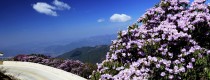
Introduction
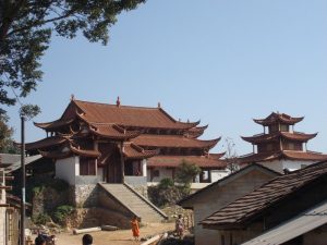
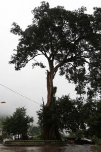
Canglong Cave is the hiding place of Prince Dragon, located in Cangyuan County, Yunnan Province, China. It’s located in the Yungui Plateau, is a cave. At present, it is in the initial stage of development and has now invested nearly 1 million yuan. It takes about 150m from the entrance of the hole to reach the fork entrance of the scenic spot. The right hole has now been developed more than 600m, and the left hole has been developed more than 800m.
Main Attractions in Canglongdong Cave
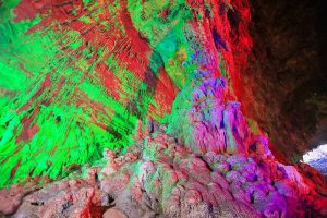
1. Baishou Hall (百兽厅)
The hall is located 120 meters after entering the cave. It’s 40 meters long, 48 meters wide and 28 meters high. The hall has stalagmites, stony columns, which are like that monkey is playing, lion is crouching, tiger is foraging and so on.
2. Shentian Hall (神田厅)
The Shentian Hall is located at 550 meters (40 meters in length, 30 meters in width, 40 meters in height; 1.7 to 1.5 meters in height and 3 meters in width) in the rockfill dam at the bottom of the cave.
3. Guanyin Hall (观音厅)
There are full of magical color in Guanyin Hall. A stalagmite at the gate of the hall is very much like the treasure lotus in which Quan yin rides. Walking into the hall, the stone pillar looks like a Wa girl, some like a giant Ganoderma lucidum, and some like Maitreya sitting in a lifelike, lifelike manner.
4. Talin Hall (塔林厅)
The Tallinn Hall is located 300 meters in the branch hole. There are dozens of stalagmites, stone columns, about 8-15 meters high, one stone pillar is about 20 meters high.
How to Get & Leave There
By Air
Cangyuan Washan Airport (沧源佤山机场) is an airport being built to serve Cangyuan Wa Autonomous County in Lincang, Yunnan province, southwest China. The airport is located in Nuoliang Township (糯良乡). Construction began on 20 December 2013, the airport have been opened to navigation by the end of 2016. It is the second airport in the prefecture-level city of Lincang, after Lincang Airport.
By Long-distance Bus
1. Cangyuan Bus terminal (沧源客运站)
Address: Provincial highway 314, Cangyuan County, Lincang.(临沧市沧源佤族自治县314省道)
Tel: 0883-7121237
2. Mangka Bus terminal (芒卡客运站)
Address: Mangka Town, Cangyuan County, Lincang (临沧市沧源佤族自治县芒卡镇)
3. Cangyuan Automobile Transport Company
Phone: 0883-7121699 (+86-0883-7121699)
Address: MengDong Street, Cangyuan autonomous county, LinCang, Yunnan.
Travel Tips:
1. Dress: The climate here is the subtropical monsoon climate, annual average temperature is 17.2℃, the lowest temperature is -1.3℃. Therefore, in Summer and Autumn, you don’t have to take a lot of warm clothes, but a coat for slightly dropping in the temperature on rainy days; In spring and winter, even if it’s not so cold, you should keep warm because we don’t have heating there.
2. Sunscreen: Yunnan province is on the Yunnan-Guizhou plateau with enough sunshine and strong ultraviolet ray, so sun cream is needed. In addition, you can prepare a hat or sun-proof clothing.
3. Safety: Yunnan is a mountainous region, so is Cangyuan. You are supposed to watch your step, especially in Canglong Cave.
Sigangli Cave
Sigangli Cave in Cangyuan (沧源司岗里溶洞) is 3 km from Menglai Village of Cangyuan County. Sigangli means coming from the cave in Wa language. Geological evolvement for numerous years forms plenty of hall in the hole, stalagmites in the hall, stalagnate in different poses and with different expressions, and rich spectacle combination. Some of them seem petty monkey playing around, lion squatting, tiger looking for food etc. Especially, there is a stalagnate, about 20 m high, 1.6 m root thick, standing upright between heaven and land. The stalagnate is small at the upper part but big at the lower part, decorated with stone pattern on it which looks like one by one stone towers, clean and white, acclaimed as the acme of perfection.
How to get to Sigangli Cave?
Sigangli Cave is located in the Luoshui Cave of Cangyuan County, Lincang City, Yunnan Province. It is 3 km from Menglai Village. There is no shuttle from the citi to Sigangli. Travelers can rent a car or drive to Sigangli Cave.
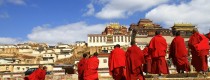
Wa Ethnic People
The name of the Wa legend—Sigangli—means “coming from the cave”, referring to the cave in Awa Mountain where the Wa (followed by other peoples such as Han, Lahu, and Dai) originated. This legend records the history of their migration and the origins of their agriculture, use of fire and iron tools and religious practices. It suggests that the Wa people were the original inhabitants of this mountain region. They went through a transition from a hunting-gathering mode of production to agriculture and from a matrilineal to a patrilineal kinship system, and for a long time they have interacted with other peoples such as Dai and Han.
Formation of Sigangli Cave
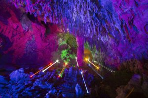
The Sigangli Cave was originally an ancient underground river. Due to years of geological evolution, the formation changed and the river was diverted. The dry underground river has been eroded by the rainwater on the ground for many years. The limestone gradually dissolves and forms a plurality of cave halls through precipitation and condensation. The stalagmites and stone pillars in the hall are in various poses forming the fantastic view. In particular, there is a stone pillar about 20 meters high and 1.6 meters thick. Like a stone tower, it is white and crystal.
What to See
The fantastic of the cave, except for the name, is due to the accumulation and precipitation of karst for many years, and the stalactites are formed in various poses. A stalagmite rises from the bottom of the cave, like a carved sculpture supporting the entire top of the cave. The dome-shaped cave top makes the cave look magnificent.The hole is not very big, but it is magnificent inside, like a colorful concert hall. This is a natural summer resort with the breeze, because the Mengdong River flows from the bottom of the cave, so it is cool and comfortable even in summer.
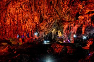
When you walk forward, you will see the stalactites, stone pillars, stalagmites, stone slabs, etc., which are strangely shaped by the multicolored lights. They are in diverse shapes, like slim young girls, uneven mountain terraces, Goddess of Mercy, mushrooms etc. When you look back at the hole, the light of the hole is like a sky opened by the ancestors of the Wa people when it is in chaos. The ancestors of the Wa people never stopped their struggles for the pursuit of light, and walked out of the cave, out of the mountains, and into the world.
Nearby Attractions
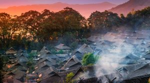
Wengding Wa Ethnic Village
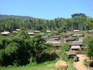
Wengding Wa Ethnic Village(翁丁佤寨) is an over 400 year-old Wa ethic village. Wengding means where the clouds are floating since mists often cloak the mountains throughout the year. People who live there have been called“ the last tribe of China’’,it has preserved the typical style of Wa residential architecture and primitive folk customs. Surrounded by lush trees, the village consists of 98 households with over 400 residence Of Wa people. The local elder stated that the woods protect the safety of the village. Inside of village has the best preserved cottages, totem, the woods, Village pillars and worship places, which reflects the splendid history and culture of Wa people. Black is auspicious color of Wa people. The elder, men and women, prefer holding tobacco pipe when they are free.
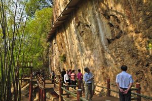
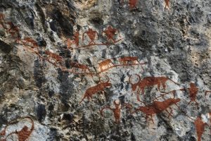
Cangyuan Cliff Painting
Cangyuan Cliff Painting (沧源岩画), the oldest cliff painting of China, enjoys the history of 3000 years. It is painted with red paint with fingers or feathers. Pigments may be made from animal blood and hematite powder. The cliff paintings mainly describe the hunting activities, production activities and entertainment activities etc. There is also a war triumph, a picture of the bamboo house and the people who hold the weapon and get back with victory. The rough and simple painting is an important material for studying the history of the ancient nationalities of south of China.
Useful Travel Tips
It is dark inside the Sigangli Karst Cave, we can pay a deposit, RMB 10, at the ticket booth to rent a flashlight.
We can take the minibus printed with “Rural Transportation” to Sigangli Scenic Spot on the central plaza of Cangyuan County, and the fee is negotiable, around RMB 260.
Cangyuan Cliff Painting
Cangyuan Cliff Painting (沧源岩画), the oldest cliff painting of China, enjoys the history of 3000 years. It is painted with red paint with fingers or feathers. Pigments may be made from animal blood and hematite powder. The cliff paintings mainly describe the hunting activities, production activities and entertainment activities etc. There is also a war triumph, a picture of the bamboo house and the people who hold the weapon and get back with victory. The rough and simple painting is an important material for studying the history of the ancient nationalities of south of China.
Why is Cangyuan Cliff Painting so special?
Cangyuan Cliff Painting is the oldest cliff painting of China, which is the important materials for studying on ancient ethnic groups. Nowadays the paintings have already been designated as the key historical relic protection unit at the provincial and national level. The cliff paintings in Cangyuan County are known for the long history, dense distribution, rich content, complete memorabilia system, and majestic promenade-style cliff-like pictures.
How to get to Cangyuan Cliff Painting?
Cliff Painting Valley is a developed place for appreciate cliff painting. It takes about 30 minutes to drive to it from Cangyuan County. Travelers had better to rent a car or drive to it since there is no shuttles.
Introduction
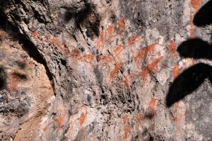
The cliff paintings of Cangyuan is said to take on different colors as the time, weather and humidity change. According to the proverb of the local Wa and Thai people that the cliff painting changes three times a day: in the morning the color is red, at noon lighter and purple in the evening. Nowadays the paintings have already been designated as the key historical relic protection unit at the provincial level.
Up to now, eleven painted cliffs have been found to scatter in the villages of Menglai, Dinglai, Mankan, Heping of Cangyuan County and the village of Mangguang of Dima County etc. Called Randianmu which means the paintings on the rocks in the local Wa language, these reddish brown ancient paintings were basically drawn on the grey limestone at the elevation of about 1, 500 meters. Measuring somewhere between one to thirty square meters, these primitive masterpieces are normally two to ten meters above the ground and include the images of animals, architectures, trees, boats, heavenly bodies like the sun or the moon, mountains and many abstract symbols etc.
Human figures and lively life scene are also the important themes of these artistic works on the sharp cliffs. The eyes, nose and other facial details of the human face are normally omitted; the painters instead paid more attention to the depiction of the human body and limbs. Apart from artistic meanings and value, many important life activities of these human ancestors such as hunting, dancing, recreation and sacrifice rituals and suchlike are vividly displayed and recorded, which seems to bring the viewers back to those mysterious and remote prehistoric ages.
Purpose of Painting
The creative motives of Cangyuan Cliff painting are not single, and various genres may have different creative purposes. In summary, there are two aspects, religious and the original notes.
Religion Belief
- Witchcraft: People believed that the painting can make their wish come true like the hunting picture giving them the successful hunting.
- Pray for a good harvest: The picture of the flock of herds stands for the wishes for the reproduction of animals. A big party means their celebration for good harvest.
- Worship and Sacrifice: The figures of god and goddess are the symbols of their believes.
Record of Life
- Record of big events: The paintings of the second place are not serious, reflecting the sights of daily life.
- Record of legendary: The legendary carries on their best wishes to life.
Recommended Tours
1 Day Cangyuan Wa Ethnic Culture Tour
5 Days Wa Ethnic Minority’s New Rice Festival Tour
Nearby Attractions
Wengding Wa Ethnic Village
Wengding Wa Ethnic Village(翁丁佤寨) is an over 400 year-old Wa ethic village. Wengding means where the clouds are floating since mists often cloak the mountains throughout the year. People who live there have been called“ the last tribe of China’’,it has preserved the typical style of Wa residential architecture and primitive folk customs. Surrounded by lush trees, the village consists of 98 households with over 400 residence Of Wa people. The local elder stated that the woods protect the safety of the village. Inside of village has the best preserved cottages, totem, the woods, Village pillars and worship places, which reflects the splendid history and culture of Wa people. Black is auspicious color of Wa people. The elder, men and women, prefer holding tobacco pipe when they are free.
Sigangli Cave
Sigangli Cave in Cangyuan (沧源司岗里溶洞) is 3 km from Menglai Village of Cangyuan County. Sigangli means coming from the cave in Wa language. Geological evolvement for numerous years forms plenty of hall in the hole, stalagmites in the hall, stalagnate in different poses and with different expressions, and rich spectacle combination. Some of them seem petty monkey playing around, lion squatting, tiger looking for food etc. Especially, there is a stalagnate, about 20 m high, 1.6 m root thick, standing upright between heaven and land. The stalagnate is small at the upper part but big at the lower part, decorated with stone pattern on it which looks like one by one stone towers, clean and white, acclaimed as the acme of perfection.
Useful Travel Tips
Please take care of yourself when discover the cliff painting.
Do not climb the cliff for appreciating or taking photos.
Protect the cliff painting and do not paint on the cliff.
Nangunhe River National Nature Reserve
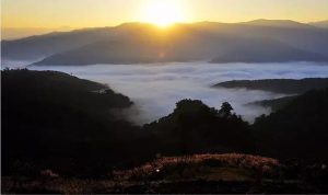
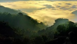
The Wa Mountain of Cangyuan is also known for its gorgeous landscape. Numerous rivers flow through the pretty peaks forest which gives rise to the favorable local natural conditions: mild climate, rich rainfall and fertilized soil. A large variety of plants and wild lives live in this Shangri-La which is often quoted as the “Plants Kingdom” or “Animal Kingdom” of Yunnan. Nangunhe River National Nature Reserve established in 1980, in December 1994 approved as a state-level nature reserve. Area of 7,082 hectares, mainly targeted at the protection of Asian elephants and their habitats of tropical rainforest ecosystems.
Why is Nangunhe River National Nature Reserve so special?
Nangunhe River National Natural Reserve enjoys the rich natural resources, including over 400 species of higher plants and over 100 species of higher animals. It is an national nature reserve.
Where is Nangunhe River National Nature Reserve?
Nangunhe River National Nature Reserve is located in Lincang City. The reserve is a mountainous landscape of the Hengduan Mountains. The highest peak is 2302 meters above sea level, and the valley is 450 meters above sea level. The reserve is located in the upper reaches of the Nangun River.
How to get to Nangunhe River National Nature Reserve?
There are 3 ways to get to Nangunhe River National Nature Reserve
1.Self-driving tour, Lincang airport– G323(old)–G214– Xiaocang Road– Gengcang Road– Gengcang Second-class Highway– Nanli Road– Nangunhe River National Nature Reserve
2.Take the shuttle bus from West Coach Station to Cangyuan bus station (around 25 hours trip)
3.Take the flight from the new Kunming Changshui InternationalAirport to Awa Mountain airport, the we need to charter a local car to Nangunhe River National Nature Reserve
Introduction
Plant Resources
There are over 400 species of higher plants. The reserve enjoys the vegetation quarter to a tropical rain forest, rainforest, and the monsoon evergreen broad-leaved forest, also many rare species like red vertebral, Manglietia, Ma pillars, Yunnan Gmelina aborea etc.
Animal Resources
There are more than 120 species of 55 families in the protected area, including more than 40 species beats of 22 families and more than 80 species of birds. The protected area is rich in economic animals, such as wild boar, red peony, scorpion, parrot, thrush, and sunbird.
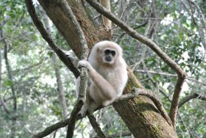
The national first-class protected animals include Asian elephant, white-palm gibbons, gray langur, bee-nosed, bengal tiger, bison, leopard, clouded leopard, green peacock and so on.
Endangered Animals
(A) Asian elephant (亚洲象) – at the national level to protect animals
The most significant feature is a long, can be curved, fleshy nose. Asian elephants live in tropical forests, grasslands, 10 ~ 30 for a group. Here the elephants not only individual is limited in quantity, low population density, age, sex ratio imbalance in the population structure. Plus the small size of protected areas, ecological balance is poor. Therefore, the protected areas elephants are in danger.
(B) White palm gibbons (白掌长臂猿)- at the national level to protect animals
Known locally as a flying monkey, it is one of the four types of human beings. The gibbons of the gibbons camp have little difference between male and female individuals. The plush is black and long, the upper arm is more than 60 cm long, the body is 40 cm long, and the tail is only 0.5 cm. When the gibbon moves forward, it moves with two upper arms clumsily. Gibbon feeds on fruits, shoots, and insects.
Nangunhe River National Nature Reserve can be used as marginal tropical situ conservation of biological diversity points.
Nearby Attractions
Wengding Wa Ethnic Village
Wengding Wa Ethnic Village(翁丁佤寨) is an over 400 year-old Wa ethic village. Wengding means where the clouds are floating since mists often cloak the mountains throughout the year. People who live there have been called“ the last tribe of China’’,it has preserved the typical style of Wa residential architecture and primitive folk customs. Surrounded by lush trees, the village consists of 98 households with over 400 residence Of Wa people. The local elder stated that the woods protect the safety of the village. Inside of village has the best preserved cottages, totem, the woods, Village pillars and worship places, which reflects the splendid history and culture of Wa people. Black is auspicious color of Wa people. The elder, men and women, prefer holding tobacco pipe when they are free.
Cangyuan Cliff Painting
Cangyuan Cliff Painting (沧源岩画), the oldest cliff painting of China, enjoys the history of 3000 years. It is painted with red paint with fingers or feathers. Pigments may be made from animal blood and hematite powder. The cliff paintings mainly describe the hunting activities, production activities and entertainment activities etc. There is also a war triumph, a picture of the bamboo house and the people who hold the weapon and get back with victory. The rough and simple painting is an important material for studying the history of the ancient nationalities of south of China.
Useful Travel Tips
· When travel in the river, if you meet the rise of water level, please do not swim in the river; meanwhile, do not play on the river bank, so as to avoid the precipitate flood.
· Please be careful when you swim in the river. It seems to be peaceful on the surface, but the situation under water is unnoticeable, if you get hurt in the river you are easy to be drowning.
· Please protect the environment of reserve, especially the rare species.
Wengding Wa Ethnic Village
Wengding Wa Ethnic Village(翁丁佤寨) is an over 400 year-old Wa ethic village. Wengding means where the clouds are floating since mists often cloak the mountains throughout the year. People who live there have been called“ the last tribe of China’’,it has preserved the typical style of Wa residential architecture and primitive folk customs. Surrounded by lush trees, the village consists of 98 households with over 400 residence Of Wa people. The local elder stated that the woods protect the safety of the village. Inside of village has the best preserved cottages, totem, the woods, Village pillars and worship places, which reflects the splendid history and culture of Wa people. Black is auspicious color of Wa people. The elder, men and women, prefer holding tobacco pipe when they are free.
Why is Wengding Wa Ethnic Village so special?
Wengding Wa Ethnic Village is one of the best- preserved ancient Wa ethnic communites in China today, also the intangible culture heritage protection unit and historical village of Yunnan Province. The Village was list as the third batch of national famous tourism villages with characteristic landscape by the Ministry of Housing and Urban Rural Development and National Tourism Administration. It is also one of top 10 beautiful village of Lincang City. It is known as the last tribe of China.
Where is Wengding Village?
Wengding Village(翁丁村) , is located in the southwest of Lincang, Yunnan province. It is 17km away from the township government and 39 km from the seat of Cangyuan county.
How to get to Wending Village?
The traffic there is very convenient and the roads to country side are laid with asphalt. It is about 40 km from Cangyuan County. It takes you 1 hour to drive to the Wending Village.
Profile of Wending Village
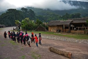
Follow the path to inside of the village, the thatched cottages and the livestock shed are next to each other. Women in Wa national costume weaving cloth in the courtyard, children playing and have fun together. The ox are around everywhere. Talking a Walk to local village’s home, the hospitable villagers will treat you with black tea and dialect. A branch with green leaf hanging in the entrance of the house means that a home born with a new life. You will have a commanding view of the village on the top of the hill ,smoke is curling up from the cottages, everything looks serenity and peaceful.
People beat the drum and sing happily to express their warmly welcome to guest. Wengding Wa Village has been published in the list of national intangible cultural heritage by the people’s Government of Yunnan province in 2006 because of the unique cultural phenomenon in Wengding Wa Village has preserved well. Wengding Wa Village attracts visitors all around the world and also transfer its culture to the rest of world.
Taking a random walk inside the village, the very first thing comes into your sight is the aged village and tall Banyan trees, guarding the villages for hundreds years. At the same times, you may shocked by the bull head hunging on the village entrance, and it is looks mysterious and amazing.
For centuries, Wengding still remains the railing architectural style, there are two types of cottages: those that single and lonely old people are live in the oval low cottage; those that two –story railing design enable people using the ground floor for feeding livestock and the upper for accommodation. In addition, local villagers will build a storage room without lock near the cottages to keep food. The Wa people believe that the woods besides the village can not be cut for guard the village, so the whole village is surrounded by lush tree.
What to See
Wengding Wa Ethnic Village enjoys the charming landscape and traditional architectures etc. It is a approving place to discover the traditional Wa culture.
Village Pillars and Heart of Village- Pray for Happiness (寨桩寨心 祈愿求福)
Village pillars, the village heart and Sigangli(a wooden stick) are the most mysterious power of the village. The three items stand in the middle of the village and they were believed to be the core of the village. It is a wonderful gathering place with a heavy flavor of life where is suitable for kinds of activities, such as playing ground for children, date for the young, leisure for the elder and worship for local people.
Village pillars, as the core of the village, they believe that as long as you have a sincere heart for pray, your dream will come true. Above the pillars there placed a lot of daily necessities such as crop stick, it is s pray for the rich harvest. From the bottle to top of the pillars, there are 13 layers in total with tripod, iron pot, pot circle and others, which means the reproduction of human beings. There is a bamboo stick and crop-made wreath standing at the highest of the pillar. The wood boat is the source of life in Sigangli tale, the wood bird standing at the boat to help herd and the wood fish swimming under the boat.
There is a public room, 5 m away from village heart, which provide for the young has date and those temporary stopover.
Huotang Culture (火塘)
Huotang, a Chinese style fireplace, is one of holy custom to Wa people. Wa people light the fires in their new home and they will not extinguish the fire. The fire means harmony and prosperity for home and family.
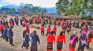
Monihei Carnival (摸你黑节)
“Monihei Carnival” (making you black) is a mud smearing carnival of the Wa ethnic group. It is originated from the folk custom that people smear the pot ash, ox blood and mud on their faces to frighten the evils and seek peace. The Monihei Carnival is held in late April or early May each year in Cangyuan County, one of the only two Chinese Wa autonomous Counties in southwest China’s Yunnan Province.
The activities of the “Monihei Carnival” of Wa ethnic group mainly involve a grand opening ceremony of song and dance performance, ethnic arts tour, a crazy and passionate “making you black” activity with thousand of people’s participation, ancient cliff painting worship, songs about life in Washan Mountain, campfire party and Wa songs concert.
Tourists can use natural paints to smear each other and pray for each other. “Monihei Carnival” has attracted more and more tourists both from home and abroad to join the activity.
Recommended Tours
1 Day Cangyuan Wa Ethnic Culture Tour
4 Days Cangyuan Wa Ethnic Minority Discovery Tour
4 Days Cangyuan Monihei Carnival Tour
5 Days Wa Ethnic Minority’s New Rice Festival Tour
Nearby Attractions
Cangyuan Cliff Painting
Cangyuan Cliff Painting (沧源岩画), the oldest cliff painting of China, enjoys the history of 3000 years. It is painted with red paint with fingers or feathers. Pigments may be made from animal blood and hematite powder. The cliff paintings mainly describe the hunting activities, production activities and entertainment activities etc. There is also a war triumph, a picture of the bamboo house and the people who hold the weapon and get back with victory. The rough and simple painting is an important material for studying the history of the ancient nationalities of south of China.
Useful Travel Tips
1. Best time to visit: Travelers can visit the Wengding Wa Ethnic Village during April 29 to May 1, you can enjoy the local carnival in this period and discover more traditional culture.
2. Acoommodation: Travelers can accommodate at the home of villagers. It is relative cheap to eat and stay in their home.
3. Respect the local custom of Wa people, especially their believes.
Chinese Name: 沧源佤族自治县班老乡上班老村永东佛寺(上班老佛寺)
English Name: Shangban Temple in Cangyuan County, Lincang
Keywords: Shangban Temple in Cangyuan County, Cangyuan Attraction, Cangyuan Travel
Address: Shangban Temple is located near Shangban old village committee, Banlao town , Cangyuan Awa Autonomous County.
Admission Fee:
Opening Hours:
Brief Introduction of the Shangban Temple
Shangban Temple named after Shangban Village in Dai language is located near Shangban Village of Banlao town , Cangyuan Awa Autonomous County. It was built in Guangxu period during Qing Dynasty(1875 AD.)with bamboo and wood structure. Banlao town returned to the motherland in 1960, meanwhile, in order to maintain the stability of the frontier and to promote national unity, the local government drew money18 thousand yuan from working funds of new district, at the same time the local people raised money 22 thousand yuan, all the money was used to build new Buddha hall, idiorrhythmism, and kitchen. Administration for religious affairs of Yunnan province donated a 50-cm jade Buddha to the Shangban temple.
History of the Shangban Temple
During the Great Cultural Revolution, the temple was used for other purposes. After the Great Cultural Revolution, this temple was given back to the believers, so they could have normal religious activities again. Administration for religious affairs of Yunnan province allocated funds 33 thousand yuan so as to change the building into wood and brick structure with carved doors and windows on April, 1986. On 1987, it was listed as a key buddhist temple by the provincial government. The government of the county invited craftsman from Nanjian Yi Autonomous County to mold a 3.2-meter-high Sakyamuni Buddha(clay figurine) on 1988. With the approval of the related departments, the temple was put into reestablishment, completed on October, 2010. The total investment was about 2 million yuan. The whole building group consists of Buddha hall, idiorrhythmism, and white tower, covering an area of 2000 square meters. The Buddha hall built in crossing bracket type and three double-hipped roof rested on the top with an area of 312.8㎡. All the believers are the Va nationality.
Attraction Transportation: To take the local bus to Banlao town
Attraction Travel Tips: Don’t take photos before the Buddha, your flashlight may hurt the surface of the Buddha. To show your piety to the Buddha, please don’t be dressed too casual.
The Location Map of Shangban Temple in Cangyuan County, Lincang
Chinese Name: 沧源县勐角傣族彝族拉祜族乡勐卡村
English Name: Cangyuan Mengka Village
Keywords: Dai ethnic group, Buddhist temple, Cangyuan attraction
Address: Mengka Village belongs to the west of Mengjiao Dai Yi Lahu Autonomous Village, Cangyuan Va Autonomous County, 27 KM away from Mengjiao town government
Admission Fee: Free
Opening Hours: All the day
Mengka Village
Cangyuan Mengka Village, a lost original village in Awa Mountain
Mengka Village is located in the west of Mengjiao Dai Yi & Lahu Autonomous Village, Cangyuan Va Autonomous County, 27 KM away from Mengjiao town government, 43 KM away to the county. The traffic is very convenient, the road to the town is paved by stone. Mengka Village is surrounded by Nuozhang Village in the east, Manggong Village in the south, Banhong town in the west, and Wending village in the north. Mengka New Village, Mengka Old Village and so on are under it’s jurisdiction.
Mengka Village is located in the west of Mengjiao Dai Yi & Lahu Autonomous Village, Cangyuan Va Autonomous county, 27 KM away from Mengjiao town government. The main ethnic group is Dai nationality, it is amazing that visitors can see one tree makes a forest due to the superior geographical environment, hot and humid weather, as well as the significant tropical climate. The buildings in Mengka Village maintain a more primitive Dai style compared to the Dai village around the county, the bars are decorated with gilding flowers, and the temples are quiet. The costume of the Dai ethnic group are colorful, however, the clothes of the people in Mengka Village are more simple. The senior citizens usually wear a white towel on their head, most of their clothes are based on sky blue and light blue, while their skirts are mainly focusing on black.
Mengka Laozhai Temple
Mengka Laozhai Temple is 26 KM away from town government, 41 KM away to the county and only 4 KM to the Wending Va Primitive Village. Mengka Laozhai Village is a Dai village with advantageous natural conditions and convenient traffic. There are many well-preserved stilted buildings in traditional Dai style with profound humane culture. Mengka Laozhai Village Temple belongs to Mahayana Buddhism in Pali language. It built since 1380 AD, unfortunately, it was ruined in 742 of Dai year during the Cultural Revolution in China. Then it was rebuilt in March, 1981 with an area of 2000㎡. The Buddha hall facing the north which is in crossing bracket wooden frame type with two double-hipped roof rested on the top. The whole temple is made up of Buddha hall, white tower and door kiosk covering an area of 500 ㎡, all the believers are Dai people.
Attraction transportation: We can take the shuttle bus from Cangyuan County bus station.
Attraction Travel Tips: ·Respect the customs of the local inhabitants
·Do not take photos in the Buddha hall
The Location Map of Mengka Laozhai Village in Cangyuan County, Lincang
Chinese Name: 沧源县勐来大峡谷(千米国画长廊)
English Name: Menglai Grand Canyon or Thousand-Meter Gallery
Keywords: Cangyuan rock paintings,Menglai Grand Canyon,Thousand-Meter Gallery
Location: Canyuan Va Autonomous County
Admission Fee: RMB 30
Opening Hours: 08:00-18:00
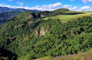
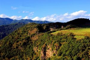
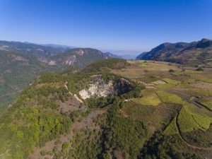
About Cangyuan Rock Paintings Valley
Cangyuan rock paintings valley is a natural scenic spot based on rock paintings,taking Va ethnic folk cultures as the core. It is a comprehensive tourist area combined with ethnic culture, folk custom, natural landscape and cultural landscape. It is 78km in length and 600 hectares in acreage. This scenic area is made up of Canglong Valley, Thousand-Meter Gallery, rock painting scenic spot, Mengdong Port, and Yonghe Port.
Thousand-Meter Gallery
Menglai Grand Canyon is also called Thousand-Meter Gallery, situated at the middle part of the scenic spot. The rock paintings in the area is about 3KM. The cliff is about 80-180 meters high and the highest one is about 280 meters. Some of the cliff surface is ragged like a honeycomb, and some are flat and smooth as if cut by the axe, while some are just like the terraced fields. Due to the erosion of some special materials and the decoration of the climbing plants, the surface the cliff becomes colorful just like a giant rock paintings reflecting the vicissitudes of the nature.
Evaluation of the Cangyuan Rock Paintings
Cangyuan rock paintings is an masterpiece left by VA ancestors 3000 years ago, while Thousand-Meter Gallery is a natural landscape created by nature without artificial factors, fully incarnating its magic power. It forms an unique cultural and natural landscape with the rock paintings. However, the locals don’t believe it’s formed naturally so they give the Thousand-Meter Gallery a mysterious tale.
Attraction Transportation: Take the shuttle bus from Lincang City bus station, or you can drive by yourself.
Attraction Travel Tips: · Do not take photos in front of the rock paintings.
· pay attention to the rough road.
The Location Map of Menglai Grand Canyon in Cangyuan County, Lincang
Introduction
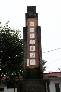
The “Banhong incident”, which shocked China and foreign countries, was the historical event of the patriotic and anti-British struggle of the WA people in the period of China’s democratic revolution, the Banhong and Banao areas, and the unity of the people of all ethnic groups in the southern border of the motherland to resist aggression and safeguard national unity.
Banlao Town
Banlao town(班老乡) is located in the west of Cangyuan Va Autonomous County of Lincang City, 95 KM away from the county, situated in the 98°53′00″to 99°03′37″of east longitude, 23°09′45″to 23°19′55″of north latitude. It’s bordering with Nangunhe National Nature Reserve(南滚河自然保护区) in the east, Nanla Village of Mangka Town(芒卡镇南腊村) in the north, and Va state of Myanmar(缅甸佤邦) in the west and south, sharing 41.65KM boundary line with Myanmar. Meanwhile it’s a town with the longest boundary line of Cangyuan Va Autonomous County, facing Banhong Town on the other side of the river. Within the town, the highest point is 1530 meters, the lowest is 480 meters, and the average annual temperature is 21℃. The Rainfall is quite abundant with average annual rainfall 1900 to 2400mm.
Related Events
Banhong Incident(班洪事件)
Banhong Incident(班洪事件) shocked China and the whole world, it is an anti-British battle leading by Va ethnic people in Banhong and Banlao area during the democratic revolutionary period. It is a glorious feat that the people on the south border of China united together to safeguard national unity defending the invasion.
The British imperialist soldiers occupied Myanmar in 1885, then they continued to invade Awa Mountain area of China, aiming to expand their interests in the Yangtze river area.
When China and British sitting together to talk about the national boundary line in 1900, British regarded Banhong area not as part of China unreasonably. They put the south part of boundary line, called the Gourd King Area(葫芦王), which Va ethnic group lived on as the uncertain border. They were so eager to occupy this area due to the abundant mineral resources that they didn’t admit Banhong area as part of China.The invasion of the British Imperialism stirred up the anger of the Va people, they resisted firmly. The British armed forces planned to go through Bannong(班弄), Banlao(班老), and Banhong(班洪) then arriving at Mengjiao(勐角) area of Dai ethnic group. But the King of Banhong area, Hu Yushan, didn’t allow them to pass, at the same time, he ordered his secretary to send a letter and a basket of egg to Scott, the leader of the British armed forces. Scott was so arrogant when he received these gifts, but after reading the letter he became angry soon, the letter was written as, the Gourd King Area is part of China, you can not occupy it rudely, but if you dare to invade, we will resolutely fight all forms of invasion. Later on, the interpreter told him that, this basket of eggs were not a gift but means as Get out of here, and never come back! In Va language. Scott was so pissed off, but he couldn’t do anything. He had no choice but to take all the soldiers and related officers to bypass Mengding(孟定), encamping in Mengjiao area with related Chinese officers, Liu Wansheng,Chen Can.
Huangguo (Orange) Event(黄果事件)
3 subordinate soldiers of Scott riding horses to rob the orange(黄果) of Va ethnic group at Mengdong(勐董) market in Yonghe, and shot a Va people who was selling orange. This event annoyed the Va and Dai people on the market, two of the soldiers were killed by the angry crowd. After the Huangguo (Orange) Event(黄果事件) broke out, Scott sent his armed forces to attack Mengdong and Yonghe wildly, burning, killing and looting, many villages were destroyed in the fire.
When Hu Yushan was informed of the Huangguo (Orange) Event(黄果事件) , he sent soldiers immediately to guard Wending Mountain(翁丁大山) between Mengjiao(勐角) and Banhong(班洪). At the same time he allied 3 tribes, Yonghe, Shaoxing(绍兴) and Shaopa(绍帕) to fight against the British army. In the end the British was defeated fleeing to Myanmar.
As the failure of the Huangguo (Orange) Event(黄果事件) in 1900, the British colonists realized that they couldn’t conquer the people in Gourd King Area by force. But they were unwilling to give up invading Gourd King Area which had abundant mineral resources. Then they tried to invade local culture by missionary work, but the missionary sent by British colonists were excluded out of Gourd King Area by Hu Yushan. This missionary conspiracy was failed at last.They know it clearly that this King, Hu Yushan, was smarter and more powerful than the tigers siting in the mountain, if they didn’t wipe out him, they would not occupy an inch area of the Gourd King Area, not to speak of the glittering silver mine. So they tried their best to play new tricks to bribe Hu Yushan, but they met their Waterloo.Finally they cultivated pro-British, and sent spies to interior area of Awa mountain to map the topography, search mineral deposits, and transport rock specimens secretly. Even they sent troops to shoot our Va compatriot, firing local inhabitants’ village, so as to dismember and occupy our border areas, as well as loot the abundant mineral resources.
Subsequent Development
Later on, with the support of the whole society , as well as the people of Banhong and Banlao stick to fighting against the British, then the second frontier survey was begun from 1935 to 1937. Seeing these historical facts, the British finally admitted that Banhong area was part of China. In 1960, China and Myanmar solved the border problem smoothly and successfully, Banhong area returned to the embrace of the motherland.
Banhong Anti-British Battle Monument was named as an educational base of patriotism by the Yunnan provincial government. Now it is listed as a provincial-level base for “defence education”. We Va people inherited and promoted the self-improvement, struggled diligently spirit. We believe that under the guidance of the CPC Central Committee and the State Council, with the support and help of the friends from various circles in China, we all join hands together to build a better tomorrow of Awa mountain.
Attraction Transportation
We can take the shuttle bus from the county bus station to Banhong town.
Travel Tips:
Pay attention to the rough road in mountain area.
Chinese Name: 沧源司岗里崖画谷
English Name: Sigangli Cliff Painting Valley in Cangyuan County
Keywords: Sigangli Cliff Painting Valley, Rock paintings, Cangyuan attractions
Location: Menglai Town of Cangyuan County in Lincang
Admission Fee: RMB 30
Opening Hours: 08:00-18:00
About Sigangli Cliff Painting Valley
Cangyuan Rock Paintings found in China is the most ancient Rock Paintings of a more than 3,000 years ago in the late Neolithic Age. The unique karst landforms scenic spectacular beauty, talent, natural ; has world-renowned rock paintings ; are known as the Yunnan tours first pit, extraterrestrial footprints called Yunnan’s largest sinkhole and cave group (one of the biggest pit, 235 meters deep, more than 200 meters in diameter, circumference 720 meters) ; there contiguous forest flora of the Jurassic period – Cyathea, Dong palm forest, there are magnificent kilometer natural color wall painting gallery. Fresh and unique Va Walled villages scattered among the mountains, colorful style shine Va which make beautiful canyon scenery exceptionally charming.
Rock Paintings have been found 11 sites, located in Cangyuan County Meng to the rural, small townships to full Hom townships, and rural peace and the Flemish-Gengma County township, and other places, generally at an altitude of about 1,500 meters on the cliff.
Grey limestone quarry face painting, a painting of ochratoxin red, the local Va people called “Code with the Alem”, which means rock paintings. Rock Paintings locations screen high ground from 2 to 10 meters, long painting area ranging from 1 to 30 meters, small frame, composed of a number of scattered graphics, the image of several hundred, 187 animals, housing 25 Road 13, the symbol of Italian Table 35; there are trees, Zhouchuan sun, clouds, mountains, and the earth, such as bags like Fig. Graphic descriptions of characters are officially 100 law, and to single monochromator Le Tu Jia-ping, save facial detail, such as drawing silhouettes-way through the performance of the limbs variety of characters engaged in various activities.
Ancient Rock Paintings vividly demonstrate the ancient ancestors hunting, grazing, villages, war, dance, acrobatics and religious activities such as worship, rich in content, composition concise, crude ore, uninhibited, tasks, and image Variety animals, lifelike, independence in terms of style, vividly demonstrates the ancient ancestors of life scenes. The study of ancient history of the nation, religion, culture, arts, and other important values, state-level key units to be protected.
Amazing Scene of the Rock Paintings
The cliff paintings of Cangyuan is said to take on different colors as the time, weather and humidity change. According to the proverb of the local Va and Thai people that the cliff painting changes three times a day: in the morning the color is red, at noon lighter and in the evening purple. Nowadays the paintings have already been designated as the key historical relic protection unit at the provincial level.
Up to now, eleven painted cliffs have been found to scatter in the villages of Menglai, Dinglai, Mankan, Heping of Cangyuan County and the village of Mangguang of Dima County etc. Called Randianmu which means the paintings on the rocks in the local Wa language, these reddish brown ancient paintings were basically drawn on the grey limestone at the elevation of about 1, 500 meters. Measuring somewhere between one to thirty square meters, these primitive masterpieces are normally two to ten meters above the ground and include the images of animals, architectures, trees, boats, heavenly bodies like the sun or the moon, mountains and many abstract symbols etc.
Human figures and lively life scene are also the important themes of these artistic works on the sharp cliffs. The eyes, nose and other facial details of the human face are normally omitted; the painters instead paid more attention to the depiction of the human body and limbs. Apart from artistic meanings and value, many important life activities of these human ancestors such as hunting, dancing, recreation and sacrifice rituals and suchlike are vividly displayed and recorded, which seems to bring the viewers back to those mysterious and remote prehistoric ages.
Attraction Transportation: We can take the shuttle bus from Lincang bus station to Cangyuan County, then we need to charter a local car to go with a negotiable price.
Attraction Travel Tips:
· 2-3 hours travel.
· The tour of viewing the cliff painting is subject to the weather condition. Visitors who plan to see the painting should therefore consult the local travel agent about the timing of their visit in advance.
· Lincang is rich in rainfall and the rainy season comes from May until October.
The Location Map of Lincang Sigangli Cliff Painting Valley in Cangyuan County
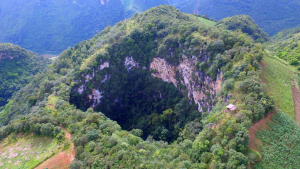
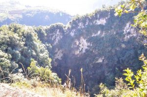
Chinese Name: 沧源天坑
English Name: Tiankeng Dolines in Cangyuan County
Keywords: Tiankeng Dolines in Cangyuan,Cangyuan attractions, Cangyuan tours, karst landform
Location: These Tiankeng Dolines are located at the middle of the Cliff Painting Valley in Cangyuan
Admission Fee: Free
Opening Hours: All the day
Tiankeng Dolines in Cangyuan County
Tiankeng is called funnel karst landform in geography, Tiankeng Dolines in Cangyuan County is the biggest one in Yunnan province. Tiankeng Group of Cangyuan County in China is a large, steep-walled, pit-like, negative, karst landform that opened from beneath towards surface, with both its depth and its diameter more than 100 m to several hundred meters, developed in a great thickness of continuous soluble rocks within the aquifer vadose zone above deeply buried water table and connecting with an active cave river at its foot. It is also characterized by its tourism values of rarity, grandeur and spectacular magnificence, and by its special ecological environment.Apart from this biggest one in front of us, there are other 6 tiankeng lie in same level line. It was said that once a man climbed down the cliff, seeing an unfathomable cave. Inside the cave there are lakes, waterfall and a great number of stalactites.
What is Doline or Tiankeng?
A doline, sink or sinkhole is a closed depression draining underground in karst areas. It can be cylindrical, conical, bowl- or dish-shaped. The diametre ranges from a few to many hundreds of meters. There are two different mechanisms for the forming of dolines:
Solution
The corrosive solution of limestone by rainwater is very high in the area fo crack, allowing the water to run into the rock. This normally forms the bowlshaped type of dolines.
The solution produces large amouts of clay (depending on the pureness of the limestone). This clay is water resistant and sometimes plugs the drainage, so little lakes of rain water can sometimes be found in dolines, a rare thing in waterless karst areas.
Collapse
When a cave grows, there may be a point where the roof of a cavern is not stable enough. This results in (several) collapses that shape the roof like a dome. This process runs out, when the shape is able to hold the weight of overlying rocks.
If the impact of this collapse reaches the surface, if the overlying layers are too thin then the ceiling collapses and a doline is formed. The doline is often a natural entrance to the cave.
Discoveries of Karst Tiankengs in China
Karst tiankengs have been known as “large collapse dolines” for a long time, since small number of them have been discovered around the world, but they have received little attention in academic research. In China, the large collapse dolines that were first widely known are in Sichuan Province. Then more such dolines were reported in Guangxi Province, mostly as marvelous natural scenery. From early 90s up to now, a series of karst tiankengs were found and studied in China by Sino-foreign cave expeditions and other many research projects sponsored by Geological Society of China and Institute of Karst Geology of the Chinese Academy of Geological Science. It is during this period of extensive research that the name “karst tiankeng” is formally proposed and widely recognized as the right terminology for this unique geological formation.
There are about 50 karst tiankengs known in China. Of these, 3 are giant tiankengs more than 500 m deep and 500 m in entrance diameter – Xiaozhai Tiankeng in Fengjie of Sichuan, Dashiwei Tiankeng in Leye of Guangxi and Haolong Tiankeng in Bama of Guangxi. There are also 5 large tiankengs more than 300 m in depth and entrance diameter.
Distinction between karst dolines and karst tiankengs
Karst doline is one of the most familiar and distinctive landforms in karst terrains. There are several doline types that form in the soluble rocks, including the corrosion doline, the permeable doline, the suffosion doline and the collapse doline. Of collapse dolines, there are karst bedrock collapses and also collapses in insoluble rock that covers a buried karst, but the size of all these do not match the size of a tiankeng. To date, dolines found in carbonate rocks have diameters and depths up to about 100 m. Steep-walled, pit platform is different from all the main doline types, they differ not only in size but also in their development mechanisms and conditions. Why is a large karst doline now named as a karst tiankeng? The basic reasons are:
A tainkeng develops in special environmental conditions that integrates aspects of geology, geomorphology and hydrogeology, but a common doline develops in a much wider range of karst environments. Consequently, dolines and collapse dolines are widespread while karst tiankengs are very few within the global picture of karst.
A tiankeng differs greatly from dolines and collapse dolines in its development and erosion mechanisms. The common collapse doline forms by dissolution and suffosion in normal geological and hydrodynamic environments. Collapse tiankengs have developed through an unusual hydrodynamic combination of erosion, dissolution and collapse where three evolutionary stages may be distinguished – from a cave river to an underground cavern to a tiankeng open to the surface – this is not comparable.
A tiankeng is very different from a normal doline in size. It is very large and broad.
Tiankeng have close relationships with the regional development of cave river systems, and their distribution, evolution, age and development rates are not comparable to those of common karst dolines.
Genetic Types and main features of karst tiankengs
Current research suggests that tiankengs developed in carbonate rocks may be divided into two types-collapse tiankengs and erosional tiankengs. The former is much more widespread and numerous than the latter.
Collapse tiankengs
Collapse tiankengs formed in soluble rocks in which massive amounts of rock material were dissolved and eroded away at depth by an intensely dynamic underground drainage system, notably by large cave river system. Under specific geologic and hydrogeological conditions, a cavern evolved as its roof failed gradually while the falling rock debris was carried away by water, until it opened to the ground surface.
Erosional tiankengs
Erosional tiankengs developed in the vadose zone of soluble rocks by allogenic water eroding and dissolving the rock in its vertical descent from the surface. They are very rare because of their special environmental conditions.
Collapse and erosional tiankengs have some features basically in common, but also have some important differences in their development conditions:
A great and continuous thickness of soluble rocks
Solution sedimentary rock (generally carbonate rocks in China) is the first requirement for tiankeng development. Clearly, large and deep tiankengs developed within large thickness of soluble rock unbroken by any significant impermeable intermediate beds, so allowing the establishment of a unified vadose aquifer zone.
A deep vadose zone in soluble rocks
Karst tiankengs largely developed in the vadose zone of an aquifer above a deeply buried water table, where the thickness of the vadose zone is nearly equal to or greater than the depth of the tiankeng. Tectonic uplift and rejuvenation caused entrenchment of the surface rivers and a major lowering of the regional water table, thereby increasing the thickness of the vadose zone. Tiankengs are most common in areas of neotectonic uplift.
A favorable geological structure
The two kinds of karst tiankeng formed mainly in karst regions with gently dipping or horizontal rocks, where the soluble rocks have wide outcrops. Structural fissures, notably long and deep faults and vertical joints allow development of a strong hydrodynamic system in the aquifer. A structure with gently dipping beds and networks of joints and faults favours progressive breakdown of the roof of large cave chambers at depth. Dipping beds are eroded to outcrops with long contacts between soluble rocks and non-soluble rocks, that favour development of erosional tiankengs by allogenic drainage, such as at Qingkou Tiankeng.
A highly active hydrodynamic system with underground conduit flow in cave rivers
A tiankeng is the largest closed and negative landform in karst, involving the removal of 1-1000 million cubic meters of rock by breakdown, dissolution and fluvial transport. It definitely requires a very strong input-output hydrodynamic system, in the form of active conduit flow within a cave river system in the karst aquifer. Known tiankengs have developed in association with major karst underground river systems. The cave river is the critical factor in tiankeng development, especially for erosional tiankengs where it is the result of the tiankeng development and not its precodition.
Favorable climate and hydrogeology
A humid rainy climate supplies plentiful rainfall for dissolution and river flow, and encourages high intensity and high rate of tiankeng development in a karst. Tiankeng distribution is related to zones of humid climate and abundant precipitation.
These environmental factors are all optimally developed in the karst of southern China, especially in the high-relief cone karst areas – which include the most important tiankeng sites in the world.
Karst tiankengs provide data for karsification intensities and rates, and offer a new way to study time-scales of karst geological process. It is suggested that the tiankengs in China are the youngest and the largest negative landforms of the karst. Research is directed into the high intensities and rates of karstification and the relatively the geologic age of the tiankengs, and it is suggested that the tiankengs in China formed mainly in the late Pleistocene since 128,000 years ago.
The status of Chinese tiankengs within the karst of the world
As independent and significant karst landforms, tiankengs are not common around the world, and are infrequently studied. The largest tiankengs outside China known to date are mainly distributed through the lower latitudes, including New Britain (Papua New Guinea), Sarawak (Malaysia) and Mexico, and are few in number. Smaller tiankengs are also know in Europe close to the Mediterranean coasts. Compared with those abroad, tiankengs in China possesses significant status within the world’s karst because of the following features:
Large numbers and clustered distribution
Tiankeng in China occur mainly in the south, within the drainage basins of the Yangtze and Peal Rivers , where there are 6 major tiankengs nearly 50 in total. Many are grouped within the same drainage basins or on the same cave river systems.
Large dimensions
In nearly 50 tiankengs found to date, there are 3 oversize tiankengs (Xiaozhai, Dashiwei and Haolong), whose entrance diameter and depth are generally above 500-600 m, and there are tens of large tiankengs more than 300 m in entrance diameter and depth.Perfect formation, beautiful scenery and high values of aesthetics and sightseeing.
Tiankengs in China are mostly surrounded by precipitous cliffs, are very deep and are covered by original forest on their floors. They are characterized by their grandeur, sheer spectacle, peculiarity, and mystery. They are also valued for their aesthetics and sightseeing interest, and some including Dashiwei in Leye are open to tourism and visitors.
Important value for scientific research
This includes the integrity of the geomorphological systems of tiankengs, the difference between the two different genetic types, and the worldwide rarity of the erosional tiankengs. Tiankengs also promote active karst research. For example, the Dashiwei tiankeng group, known for its Museum of Collapse Tiankengs, is the world’s best location for tiankeng research. It has active examples of tiankengs in different stages of development and in contrasting landform environments. It lies in a typical high-relief cone karst terrain in southern China, within the Bailong subterranean river drainage basin of 835 km2, with a subtropical monsoon climate, and annual average of precipitation of 130-170 cm.
But the professional insiders warn that these Tiankengs are not constructed and developed completely, visitors must pay extra attention to the safety in these areas. Up to now, the secret of these Tiankeng Dolines are just dug part of it, with a deeper exploration more and more fancy topography and species will be found.
Attraction Transportation: We can take the shuttle bus from the bus station of the county
Attraction Travel Tips:
·It is quite dangerous around the Tiankeng Dolines, please be careful about walking steps.
·Prepare enough clothes and food, it is definitely a hard journey.
The Location map of Tiankeng Dolines in Cangyuan County, Lincang
Chinese Name: 沧源佤族自治县糯良乡班考村委会班考民俗自然村
English Name: Bankao Village
Keywords: Bankao Village, Cangyuan tours, Cangyuan highlights
Location: Bankao Village is located at Nuoliang town, Cangyuan Va Autonomous County
Admission Fee: Free
Opening Hours: All the day
Bankao Village
Bankao Village is a mountainous area located in Nuoliang town, Cangyuan Va Autonomous County, covering an area of 2.45 sq,km . This village is in the northwest of the Nuoliang town government, 1200 meters high above the sea level, 27 KM away from the town. The annual precipitation is about 1700 mm.
Transportation: To take the shuttle bus from the county bus station
Travel Tips: ·1 or 2 hours trip
·respect the local inhabitants’ manners and customs
The Location Map of Bankao Village in Cangyuan County, Lincang

You Might Like
- 19 Days Yunnan Camper Tour

- 2 Days Kunming Jiaozi Snow Mountain Tour
- 6 Days XishuangBanna Tea Mountain Hiking Tour to Bada, Zhanglang, Xiding and Nannuo Tea Mountain
- 2 Days Dali Pilgrimage Hiking Tour from Erhai Lake to Jizu Mountain
- 10 Days Yunnan Classic Tour with Meili Snow Mountain Pilgrimage (Kunming-Dali-Lijiang-Shangri La-Feilaisi)
- 10 Days Yunnan Motorbike Tour from Mohan Border to Ruili Border
- 2 Days Lijiang Lugu Lake Tour and Matriarchal Society Discovery
- 8 Days Yunnan Tour from Hong Kong


Canglongdong Cave in Cangyuan County, Lincang
Introduction Canglong Cave is the hiding place of Prince Dragon, located in Cangyuan County, Yunnan Province, China. It’s located in the Yungui Plateau, is a cave. At present, it...

Sigangli Cave in Cangyuan County, Lincang
Sigangli Cave Sigangli Cave in Cangyuan (沧源司岗里溶洞) is 3 km from Menglai Village of Cangyuan County. Sigangli means coming from the cave in Wa language. Geological evolvement for numerous...

Cangyuan Cliff Painting, Lincang
Cangyuan Cliff Painting Cangyuan Cliff Painting (沧源岩画), the oldest cliff painting of China, enjoys the history of 3000 years. It is painted with red paint with fingers or feathers....

Nangunhe River National Nature Reserve in Lincang
Nangunhe River National Nature Reserve The Wa Mountain of Cangyuan is also known for its gorgeous landscape. Numerous rivers flow through the pretty peaks forest which gives rise to...

Wengding Wa Ethnic Village in Cangyuan County, Lincang
Wengding Wa Ethnic Village Wengding Wa Ethnic Village(翁丁佤寨) is an over 400 year-old Wa ethic village. Wengding means where the clouds are floating since mists often cloak the mountains...

Shangban Temple in Cangyuan County, Lincang
Chinese Name: 沧源佤族自治县班老乡上班老村永东佛寺(上班老佛寺) English Name: Shangban Temple in Cangyuan County, Lincang Keywords: Shangban Temple in Cangyuan County, Cangyuan Attraction, Cangyuan Travel Address: Shangban Temple is located near Shangban old villa ...

Mengka Village in Cangyuan County, Lincang
Chinese Name: 沧源县勐角傣族彝族拉祜族乡勐卡村 English Name: Cangyuan Mengka Village Keywords: Dai ethnic group, Buddhist temple, Cangyuan attraction Address: Mengka Village belongs to the west of Mengjiao Dai Yi Lahu Autonomous...

Menglai Grand Canyon in Cangyuan County, Lincang
Chinese Name: 沧源县勐来大峡谷(千米国画长廊) English Name: Menglai Grand Canyon or Thousand-Meter Gallery Keywords: Cangyuan rock paintings,Menglai Grand Canyon,Thousand-Meter Gallery Location: Canyuan Va Autonomous County Admission Fee: RMB 30 Opening H ...

Banhong Anti-British Battle Monument in Cangyuan County, Lincang
Introduction The “Banhong incident”, which shocked China and foreign countries, was the historical event of the patriotic and anti-British struggle of the WA people in the period of China’s...

Lincang Sigangli Cliff Painting Valley in Cangyuan County
Chinese Name: 沧源司岗里崖画谷 English Name: Sigangli Cliff Painting Valley in Cangyuan County Keywords: Sigangli Cliff Painting Valley, Rock paintings, Cangyuan attractions Location: Menglai Town of Cangyuan County in Lincang Admission...

Tiankeng Dolines in Cangyuan County, Lincang
Chinese Name: 沧源天坑 English Name: Tiankeng Dolines in Cangyuan County Keywords: Tiankeng Dolines in Cangyuan,Cangyuan attractions, Cangyuan tours, karst landform Location: These Tiankeng Dolines are located at the middle...
Bankao Village in Cangyuan County, Lincang
Chinese Name: 沧源佤族自治县糯良乡班考村委会班考民俗自然村 English Name: Bankao Village Keywords: Bankao Village, Cangyuan tours, Cangyuan highlights Location: Bankao Village is located at Nuoliang town, Cangyuan Va Autonomous County Admission Fee: Free...
Tips Before Travel
Bring copies of your passport
Don't assume you're restricted to the main hubs of Beijing and Shanghai, our tours can start from any city.
Register with your embassy
For your safety, please register with the Embassy.
Always have local cash
Exchange some local currency for your trip
Our Team
Customize a Trip
Start planning your tailor-made holiday to China by contacting one of our specialists. Once enquired, you’ll get a response within 0.5~23.5 hours.
Latest Articles
Yunnan Travel from Dalian of Liaoning
2025-06-14Yunnan Travel from Datong of Shanxi
2025-06-14Yunnan Travel from Fuzhou of Fujian
2025-06-14Yunnan Travel from Guangzhou of Guangdong
2025-06-14Contact Info

