7 Days GolfingTour
 8 Days Group Tour
 8 Days Yunnan Tour
 7 Days Shangri La Hiking
 11 Days Yunnan Tour
 6 Days Yuanyang Terraces
 11 Days Yunnan Tour
 8 Days South Yunnan
 7 Days Tea Tour
 8 Days Muslim Tour
 12 Days Self-Driving
 4 Days Haba Climbing
 Tiger Leaping Gorge
 Stone Forest
 Yunnan-Tibet
 Hani Rice Terraces
 Kunming
 Lijiang
 Shangri-la
 Dali
Dali
 XishuangBanna
 Honghe
 Kunming
 Lijiang
 Shangri-la
 Yuanyang Rice Terraces
 Nujiang
 XishuangBanna
 Spring City Golf
 Snow Mountain Golf
 Stone Mountain Golf
Huaping County Climate
1.Geography
Located on the north bank of the middle section of the Jinsha river in northwest Yunnan province, Huaping County takes the geographic coordinates of 26 ° 21 '- 26 ° 58' north latitude and l00 ° 59 '- 101 ° 31' east longitude. It borders Panzhihua of Sichuan province in the east, Chuxiong in the south, Lijiang city in the west and Lugu Lake in the north. The county seat is 420 kilometers from the provincial capital Kunming, 220 kilometers from the Lijiang municipal government, 70 kilometers from the center of Panzhihua city of Sichuan province and 54 kilometers from the Geliping Railway Station of Chengdu-Kunming rail line. High in the northwest and low in the southeast, The county has an average altitude of 1,160 meters, with the highest altitude of 3,198 meters and the lowest altitude of 1,015 meters.
2. Climate
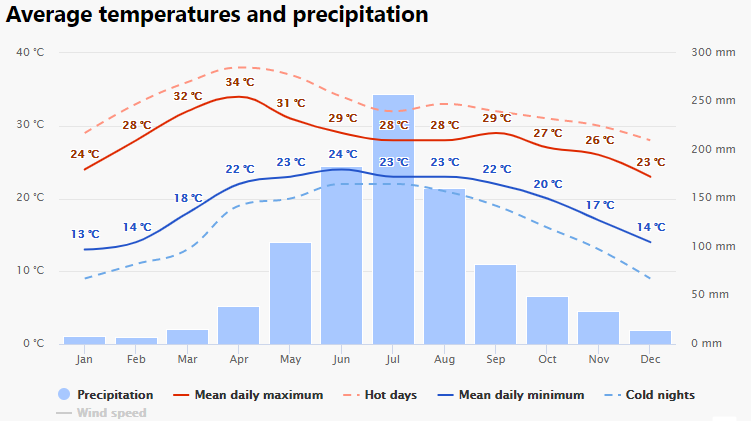
Huaping county is a typical South subtropical valley climate. The temperature and rainfall change with the elevation of the terrain, and the three-dimensional distribution is more prominent. Annual average temperature is 19.8 ℃, annual average rainfall is 870 mm, annual average relative humidity is 60%, and the annual frost-free period was 303.2 days.
3. Best Time to Visit
Huaping County is suitable to travel all year round.