7 Days GolfingTour
 8 Days Group Tour
 8 Days Yunnan Tour
 7 Days Shangri La Hiking
 11 Days Yunnan Tour
 6 Days Yuanyang Terraces
 11 Days Yunnan Tour
 8 Days South Yunnan
 7 Days Tea Tour
 8 Days Muslim Tour
 12 Days Self-Driving
 4 Days Haba Climbing
 Tiger Leaping Gorge
 Stone Forest
 Yunnan-Tibet
 Hani Rice Terraces
 Kunming
 Lijiang
 Shangri-la
 Dali
Dali
 XishuangBanna
 Honghe
 Kunming
 Lijiang
 Shangri-la
 Yuanyang Rice Terraces
 Nujiang
 XishuangBanna
 Spring City Golf
 Snow Mountain Golf
 Stone Mountain Golf
Xinping County Climate
This is the Xinping climate. The terrain of Xinping County is mainly mountainous, with an area of 4139.6 square kilometers in the county. The terrain is high in the northwest and low in the southeast. The highest elevation of the Ailao Mountain is 3165.9 meters, and the lowest elevation is 422 meters in the South Artemisia Village. Xinping County is a temperate climate zone. The local climate is affected by altitude, forming three climate types: high temperature zone, semi-mountain warm zone and alpine cold zone. The annual average temperature is 18.1 °C, the annual maximum temperature is 32.8 °C, the annual minimum temperature is 1.3 °C, the annual precipitation is 869 mm, and the total sunshine hours are 2838.7 hours. The frost-free period is 316 days.
CLIMATE GRAPH
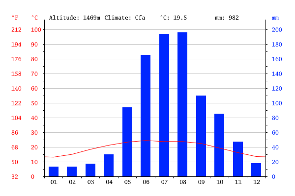
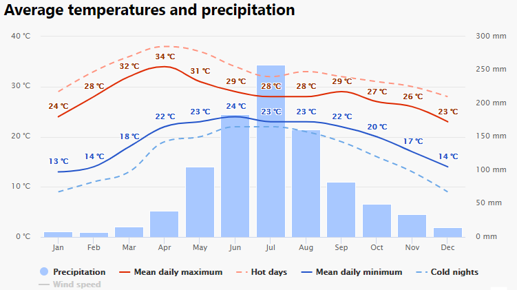
The driest month is January, with 13 mm of rainfall. In August, the precipitation reaches its peak, with an average of 196 mm.
TEMPERATURE GRAPH
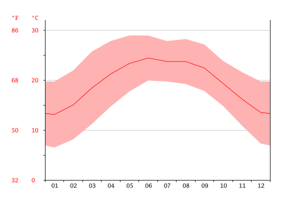
The warmest month of the year is June, with an average temperature of 24.4 °C. At 13.1 °C on average, January is the coldest month of the year.
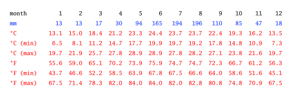
CLIMATE TABLE
The difference in precipitation between the driest month and the wettest month is 183 mm.
Best Time to Visit Xinping
A trip to Xinping is recommended in Spring and Autumn as Summer rains frequently which result in a bad condition of roads.