7 Days GolfingTour
 8 Days Group Tour
 8 Days Yunnan Tour
 7 Days Shangri La Hiking
 11 Days Yunnan Tour
 6 Days Yuanyang Terraces
 11 Days Yunnan Tour
 8 Days South Yunnan
 7 Days Tea Tour
 8 Days Muslim Tour
 12 Days Self-Driving
 4 Days Haba Climbing
 Tiger Leaping Gorge
 Stone Forest
 Yunnan-Tibet
 Hani Rice Terraces
 Kunming
 Lijiang
 Shangri-la
 Dali
Dali
 XishuangBanna
 Honghe
 Kunming
 Lijiang
 Shangri-la
 Yuanyang Rice Terraces
 Nujiang
 XishuangBanna
 Spring City Golf
 Snow Mountain Golf
 Stone Mountain Golf
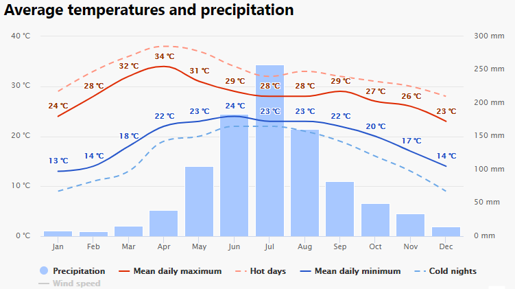
Ninglang County Climate
1.Geography
Located in the middle part of Hengduan mountain range in northwest Yunnan, Ninglang County is high in northwest but low in southeast. The mountains run through the whole territory from north to south. It is most mountainous regions in the east of Mianmian Mountain and Jinsha River alpine valley in the west of it. The highest point in this region is Baiyanzi mountain, 4510.3 meters above sea level, while the lowest point is 1350 meters above sea level at Zibu Estuary beside Jinsha river in Ningli township(宁利乡).
2. Climate
Ninglang is a plateau monsoon region of low latitude with distinct dry and wet seasons. Due to the impact of plateau and alpine canyon topography, the three-dimensional climate is remarkable. Average annual rainfall of 920 mm, annual average sunshine 2298 hours, annual frost-free period 190 days, annual average temperature 12.7 ℃. Annual extreme lowest temperature is about 9 ℃ below zero, the extreme maximum temperature will reach 30 ℃ or so.
Climate data for Ninglang (1981−2010)Month Jan Feb Mar Apr May Jun Jul Aug Sep Oct Nov Dec YearRecord high °C (°F)Average high °C (°F)Daily mean °C (°F)Average low °C (°F)Record low °C (°F)Average precipitation mm (inches)Average relative humidity (%)
| 24.6 (76.3) | 26.7 (80.1) | 27.8 (82) | 30.0 (86) | 31.4 (88.5) | 30.8 (87.4) | 32.5 (90.5) | 30.6 (87.1) | 29.9 (85.8) | 27.0 (80.6) | 25.3 (77.5) | 23.8 (74.8) | 32.5 (90.5) |
| 15.5 (59.9) | 17.3 (63.1) | 20.2 (68.4) | 22.8 (73) | 24.7 (76.5) | 25.2 (77.4) | 24.6 (76.3) | 24.6 (76.3) | 23.2 (73.8) | 21.5 (70.7) | 18.0 (64.4) | 15.6 (60.1) | 21.1 (70) |
| 4.1 (39.4) | 6.5 (43.7) | 9.9 (49.8) | 13.3 (55.9) | 17.2 (63) | 19.4 (66.9) | 19.1 (66.4) | 18.5 (65.3) | 16.7 (62.1) | 13.4 (56.1) | 8.3 (46.9) | 4.5 (40.1) | 12.6 (54.6) |
| −4.9 (23.2) | −2.9 (26.8) | 0.7 (33.3) | 4.6 (40.3) | 10.3 (50.5) | 14.7 (58.5) | 15.5 (59.9) | 14.7 (58.5) | 13.0 (55.4) | 8.1 (46.6) | 1.5 (34.7) | −3.4 (25.9) | 6 (42.8) |
| −9.7 (14.5) | −9.2 (15.4) | −6.6 (20.1) | −2.5 (27.5) | 2.7 (36.9) | 8.5 (47.3) | 8.9 (48) | 8.7 (47.7) | 2.2 (36) | −0.9 (30.4) | −5.7 (21.7) | −8.4 (16.9) | −9.7 (14.5) |
| 4.4 (0.173) | 4.2 (0.165) | 9.4 (0.37) | 18.3 (0.72) | 55.7 (2.193) | 164.1 (6.461) | 241.8 (9.52) | 213.5 (8.406) | 150.4 (5.921) | 58.1 (2.287) | 13.0 (0.512) | 3.2 (0.126) | 936.1 (36.854) |
| 60 | 54 | 52 | 56 | 62 | 74 | 82 | 83 | 83 | 79 | 74 | 68 | 69 |
3.Best Time to Visit
The months from March to October is the best time to visit Ninglang County. In addition, considering that the months from July to September is the rainy season, the road to Ninglang County will appear mountain landslide and debris flow, so do not choose this time to visit.