7 Days GolfingTour
 8 Days Group Tour
 8 Days Yunnan Tour
 7 Days Shangri La Hiking
 11 Days Yunnan Tour
 6 Days Yuanyang Terraces
 11 Days Yunnan Tour
 8 Days South Yunnan
 7 Days Tea Tour
 8 Days Muslim Tour
 12 Days Self-Driving
 4 Days Haba Climbing
 Tiger Leaping Gorge
 Stone Forest
 Yunnan-Tibet
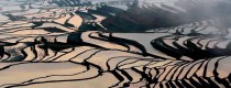
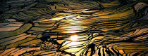
 Hani Rice Terraces
 Kunming
 Lijiang
 Shangri-la
 Dali
Dali
 XishuangBanna
 Honghe
 Kunming
 Lijiang
 Shangri-la
 Yuanyang Rice Terraces
 Nujiang
 XishuangBanna
 Spring City Golf
 Snow Mountain Golf
 Stone Mountain Golf

Location Map of Tacheng Town in Yunnan
Tacheng
塔城村隶属维西傈僳族自治县 (市、区) 塔城镇(镇),地处乡(镇)边,到乡(镇)道路为 路,交通方便(不方便),距县(市、区) 公里。辖17 个村民小组。全村国土面积 129.24 平方公里,海拔 2,000.00 米,年平均气温 13.10 ℃,年降水量 1,000.70 毫米,适合种植 稻谷、小麦、玉米等农作物。
The Location of Tacheng
Tacheng
塔城村隶属维西傈僳族自治县 (市、区) 塔城镇(镇),地处乡(镇)边,到乡(镇)道路为 路,交通方便(不方便),距县(市、区) 公里。辖17 个村民小组。全村国土面积 129.24 平方公里,海拔 2,000.00 米,年平均气温 13.10 ℃,年降水量 1,000.70 毫米,适合种植 稻谷、小麦、玉米等农作物。
The Location of Tacheng