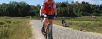
 7 Days GolfingTour
 8 Days Group Tour
 8 Days Yunnan Tour
 7 Days Shangri La Hiking
 11 Days Yunnan Tour
 6 Days Yuanyang Terraces
 11 Days Yunnan Tour
 8 Days South Yunnan
 7 Days Tea Tour
 8 Days Muslim Tour
 12 Days Self-Driving
 4 Days Haba Climbing
 Tiger Leaping Gorge
 Stone Forest
 Yunnan-Tibet
 Hani Rice Terraces
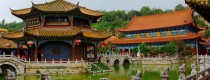
 Kunming
 Lijiang
 Shangri-la
 Dali
Dali
 XishuangBanna
 Honghe
 Kunming
 Lijiang
 Shangri-la
 Yuanyang Rice Terraces
 Nujiang
 XishuangBanna
 Spring City Golf
 Snow Mountain Golf
 Stone Mountain Golf
 What Our Customers Say?
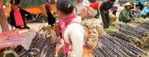
 alt="XishuangBanna Surrounding Counties and Towns: Weekly & Special Local Markets Travel Guide"
/>
alt="XishuangBanna Surrounding Counties and Towns: Weekly & Special Local Markets Travel Guide"
/>
Nature Reserves
Nature Reserves in Yunnan


Nature Reserves in Yunnan

Why is Three Parallel Rivers Natural Reserve So Special? Three Parallel Rivers Natural Reserve is a UNESCO World Heritage Site, a nature reserve extending over 170,000 km2 within the undulating...

Gaoligong Mountain National Nature Reserve Gaoligong Mountain National Nature Reserve(高黎贡山国家自然保护区) is known as the World Species Gene Bank with the high biological diversity. It runs through the southern section...

Why is Pudacuo National Park So Special Being one of the most bio-diverse regions in China’s Yunnan Province, Pudacuo National Park is the first national park in Chinese mainland...

Beihai Wetland Reserve The wetland is surrounded by mountains, located in a special geographical position, and is a typical subtropical volcanic lava barrier lake marsh wetland. The reserve features...

Chinese Name: 曲靖市会泽大桥黑颈鹤国家级自然保护区 English Name: Daqiao Black-necked Crane National Nature Reserve in Huize County, Qujing Heihe National Nature Reserve for Black-necked Cranes in Huize County, Yunnan Province曲靖市会泽大桥黑颈鹤国家级自然保护区, is located in...

OVERVIEW|The Last Oasis at 21°N Latitude 🌍🌳 Wangtian Tree Scenic Area, located 14 km north of Mengla County, Xishuangbanna, sits at the core of one of the world’s three...

🌍 Why It’s Special 💧 The Lifeblood of Kunming Songhuaba is the birthplace of the Panlong River (盘龙江) and one of the main watersheds feeding Dian Lake (滇池). Its...

Overview Meishucun Nature Reserve (梅树村自然保护区) was established in 1989 and is located 7 kilometers northwest of Jinning District (晋宁县), Kunming City (昆明市), Yunnan Province (云南省). It is recognized as...

🌿 Huanlian Mountain (黄连山) – A Biodiversity Treasure 🌱 Core Value: A Living Gene Bank Ecological Significance Area & Vegetation – Covering over 65,000 hectares, about 20% of Lvchun...

The Qinghua Green Peafowl Nature Reserve (巍山青华绿孔雀自然保护区) is located in Weishan County (巍山县), Yunnan Province (云南省), specifically in Qinghua Township (青华乡) around Beiyin Qing (背阴箐), Huangjiafen (黄家坟), and Baoziwo...
Xilongshan Nature Reserve (西隆山自然保护区) is located in Jinping Miao, Yao, and Dai Autonomous County (金平苗族瑶族傣族自治县) in Honghe Hani and Yi Autonomous Prefecture (红河哈尼族彝族自治州), Yunnan Province. The reserve spans an...

Chinese Name: 阿姆山省级自然保护区 (Amushan Shengji Ziran Baohuqu) Location: Honghe County (红河县), Honghe Hani and Yi Autonomous Prefecture (红河哈尼族彝族自治州), Yunnan Province (云南省), China Geographic Coordinates: 102°02′23″E to 102°26′7″E, 23°10′20″N to...
alt="XishuangBanna Surrounding Counties and Towns: Weekly & Special Local Markets Travel Guide"
/>
alt="Puer Surrounding Counties and Towns: Weekly & Special Local Markets Travel Guide"
/>
alt="Honghe Surrounding Counties and Towns: Weekly & Special Local Markets Travel Guide"
/>
alt="Chuxiong and Surrounding Counties & Towns: Weekly & Special Local Markets Travel Guide"
/>
alt="Kunming Surrounding Counties and Towns: Weekly & Special Local Markets Travel Guide"
/>

