 7 Days GolfingTour
 8 Days Group Tour
 8 Days Yunnan Tour
 7 Days Shangri La Hiking
 11 Days Yunnan Tour
 6 Days Yuanyang Terraces
 11 Days Yunnan Tour
 8 Days South Yunnan
 7 Days Tea Tour
 8 Days Muslim Tour
 12 Days Self-Driving
 4 Days Haba Climbing
 Tiger Leaping Gorge
 Stone Forest
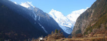
 Yunnan-Tibet
 Hani Rice Terraces
 Kunming
 Lijiang
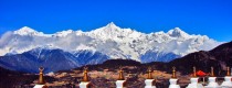
 Shangri-la
 Dali
Dali
 XishuangBanna
 Honghe
 Kunming
 Lijiang
 Shangri-la
 Yuanyang Rice Terraces
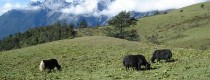
 Nujiang
 XishuangBanna
 Spring City Golf
 Snow Mountain Golf
 Stone Mountain Golf
 What Our Customers Say?
 alt="Market Days in Xuanwei City and Townships, Qujing"
/>
alt="Market Days in Xuanwei City and Townships, Qujing"
/>
Nature Reserves
Nature Reserves in Yunnan


Nature Reserves in Yunnan

Fenshuiling National Nature Reserve (金平分水岭国家级自然保护区) is located in the southeastern part of Jinping County (金平县), Honghe (红河) Prefecture, Yunnan Province (云南省), China. The reserve covers a total area of...

Overview The Honghe Cycad Nature Reserve (红河苏铁自然保护区) is located in the southeastern part of Honghe Hani and Yi Autonomous Prefecture (红河哈尼族彝族自治州) in Yunnan Province, China. The geographical coordinates are...

Overview Guanyin Mountain Nature Reserve (观音山省级自然保护区) is located in the southern part of Yunnan Province (云南省), within Yuanyang County (元阳县) of Honghe Hani and Yi Autonomous Prefecture (红河哈尼族、彝族自治州). It...

Overview Yunnan Yuanjiang National Nature Reserve is located in the south-central part of Yunnan Province (云南省), within Yuanjiang County (元江县), Yuxi City (玉溪市). The geographical coordinates range from 101°21′24″...
Chinese Name: 文山国家级自然保护区 English Name: Wenshan National Nature Reserve Overview Wenshan National Nature Reserve is located in Wenshan Zhuang and Miao Autonomous Prefecture, Yunnan Province, within the southeastern part...

Where is Samagong Nature Reserve Area – Location Samagong Nature Reserve Area萨马贡自然保护区 is located in Tacheng Town, Weixi County, with an area of 243 square kilometers. It lies in the...

Chinese Name: 永胜县羊坪水库 English Name: Yangping Reservior in Yongsheng County, Lijiang Yangping Reservoir is located 5 kilometers northeast of Yongsheng County and is named after its dam site within the...
alt="Market Days in Xuanwei City and Townships, Qujing"
/>
alt="Market Days in Huize County and Townships, Qujing"
/>
alt="Market Days in Fuyuan County and Townships, Qujing"
/>
alt="Market Days in Luoping County and Townships, Qujing"
/>
alt="Market Days in Shizong County and Townships, Qujing"
/>

