 7 Days GolfingTour
 8 Days Group Tour
 8 Days Yunnan Tour
 7 Days Shangri La Hiking
 11 Days Yunnan Tour
 6 Days Yuanyang Terraces
 11 Days Yunnan Tour
 8 Days South Yunnan
 7 Days Tea Tour
 8 Days Muslim Tour
 12 Days Self-Driving
 4 Days Haba Climbing
 Tiger Leaping Gorge
 Stone Forest
 Yunnan-Tibet
 Hani Rice Terraces
 Kunming
 Lijiang
 Shangri-la
 Dali
Dali
 XishuangBanna
 Honghe
 Kunming
 Lijiang
 Shangri-la
 Yuanyang Rice Terraces
 Nujiang
 XishuangBanna
 Spring City Golf
 Snow Mountain Golf
 Stone Mountain Golf
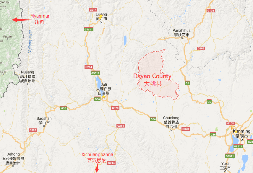
Location Map of Dayao County in Yunnan
Geographic Coordinates
Dayao County (大姚县) is located in the northern part of Chuxiong Yi Autonomous Prefecture, in Yunnan Province, China. Its geographical coordinates are as follows:
- Longitude: 100°53′E to 101°42′E
- Latitude: 25°33′N to 26°24′N
Surrounding Areas
Dayao County is surrounded by various other counties and features natural boundaries:
- East: It borders Yongren County (永仁县) and Yuanmou County (元谋县).
- South: It is adjacent to Yao’an County (姚安县) and Mouding County (牟定县).
- West: It shares borders with Xiangyun County (祥云县) and Binchuan County (宾川县) in Dali Bai Autonomous Prefecture.
- North: The Jinsha River (金沙江) lies to the north, separating it from Yongsheng County (永胜县) and Huaping County (华坪县) in Lijiang City.
Geographical Features
Dayao County’s geographical features include a mix of mountainous terrain and river valleys:
- Terrain: The county is characterized by high-altitude mountainous regions and hilly plains. The mountainous areas generally have elevations of 2,500 meters or higher, while the hilly plains range from 1,800 meters to 2,100 meters in elevation.
- Jinsha River Valley: The Jinsha River valley, which runs along the north and northwest borders, has lower elevations between 1,000 meters and 1,500 meters.
- The county is also known for its diverse landscapes, with a blend of highland plateaus, river valleys, and hills, making it suitable for agriculture and offering stunning natural beauty.
![]()
