 7 Days GolfingTour
 8 Days Group Tour
 8 Days Yunnan Tour
 7 Days Shangri La Hiking
 11 Days Yunnan Tour
 6 Days Yuanyang Terraces
 11 Days Yunnan Tour
 8 Days South Yunnan
 7 Days Tea Tour
 8 Days Muslim Tour
 12 Days Self-Driving
 4 Days Haba Climbing
 Tiger Leaping Gorge
 Stone Forest
 Yunnan-Tibet
 Hani Rice Terraces
 Kunming
 Lijiang
 Shangri-la
 Dali
Dali
 XishuangBanna
 Honghe
 Kunming
 Lijiang
 Shangri-la
 Yuanyang Rice Terraces
 Nujiang
 XishuangBanna
 Spring City Golf
 Snow Mountain Golf
 Stone Mountain Golf
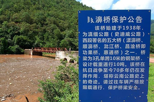
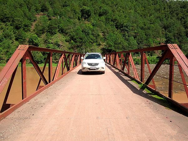
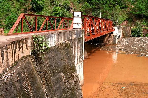
Commonly known by locals as “Shunbi Bridge (顺濞桥)” or “Steel Truss Bridge (钢架桥),” this structure is officially recorded in the Yunnan Highway History (《云南公路史》) as Shengbei Bridge (胜备桥). It is located above the Shunbi River (顺濞河), at the foot of Dahoushan (大后山), near Dashao Natural Village (大哨自然村), Pingdi Village (平地村), Taiping Township (太平乡), in Yangbi County (漾濞县).
Construction History
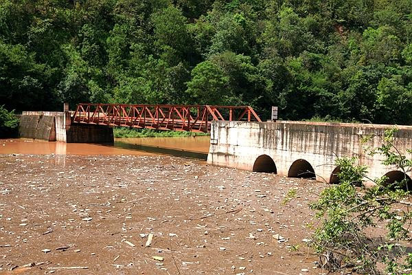
The original Shengbei Bridge (胜备桥) on the Burma Road (滇缅公路) was completed in 1938. It was a three-span stone-pier, timber-deck, layered beam bridge, with each span measuring 10 meters. On August 18, 1940, flooding destroyed the timber deck, displacing and twisting the eastern pier, rendering the bridge unusable. To maintain traffic flow, a temporary wooden bridge was constructed 75 meters upstream. This alternate bridge measured 40 meters in total (5 + 3×10 + 5 meters).
Due to wartime demands, in April 1942, engineer Huang Jingqun (黄京群) and his team redesigned the bridge. Using steel components salvaged from the bombed-out Changgan Bridge (昌淦桥), the bridge was reconstructed in 1944 as a single-span, bottom-support steel truss bridge. The new bridge measured 64 meters long, with a clear span of 6.4 meters, deck width of 5 meters, wooden planks covering the surface, and a load capacity of 15 tons. It became the second steel truss bridge constructed by the Burma Road Public Works Bureau (滇缅公路工务局).
Current Structure
Later, during the construction of the Dawan Pond Hydropower Station (大弯塘电站), the river channel was widened and water levels rose, necessitating a southward relocation of the bridge. Concrete abutments were built on both sides at its new location.
The current bridge consists of:
- A steel truss span: 37.2 meters long, 5.4 meters wide
- Bridge rails: 1.8 meters high
- Eastern abutment: 23.7 meters long, 6.2 meters wide
- Western abutment: 14.7 meters long, 6.8 meters wide
- Truss height: 2.4 meters, with 5-meter spacing between the trusses
- Load limit: 10 tons
Cultural and Historical Significance
Shengbei Bridge (胜备桥) on the Burma Road (滇缅公路) is a valuable wartime relic and a significant physical testimony to the history of the Chinese resistance during the War of Resistance Against Japan. It plays an important role in the preservation and promotion of Yangbi County’s (漾濞县) wartime cultural heritage and tourism development.
- In October 2018, it was designated a county-level cultural relic protection site by the People’s Government of Yangbi Yi Autonomous County (漾濞彝族自治县人民政府).
- On September 21, 2020, it was recognized as part of the seventh batch of prefecture-level protected heritage sites by the People’s Government of Dali Bai Autonomous Prefecture (大理白族自治州人民政府).

Protection Scope
The protected area of Shengbei Bridge (胜备桥) includes the entire bridge body and extends to the edges of both abutments.
- Eastern boundary: 10 meters outward from the protection zone, reaching the Shengbei Bridge monument
- Western boundary: 7 meters outward to the junction with the roadway
- Southern boundary: 10 meters downstream
- Northern boundary: up to the southern edge of the new highway bridge


