 7 Days GolfingTour
 8 Days Group Tour
 8 Days Yunnan Tour
 7 Days Shangri La Hiking
 11 Days Yunnan Tour
 6 Days Yuanyang Terraces
 11 Days Yunnan Tour
 8 Days South Yunnan
 7 Days Tea Tour
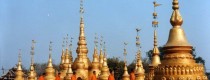
 8 Days Muslim Tour
 12 Days Self-Driving
 4 Days Haba Climbing
 Tiger Leaping Gorge
 Stone Forest
 Yunnan-Tibet
 Hani Rice Terraces
 Kunming
 Lijiang
 Shangri-la
 Dali
Dali
 XishuangBanna
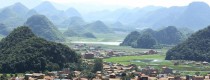
 Honghe
 Kunming
 Lijiang
 Shangri-la
 Yuanyang Rice Terraces
 Nujiang
 XishuangBanna
 Spring City Golf
 Snow Mountain Golf
 Stone Mountain Golf
Rivers
rivers in yunnan
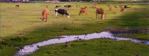


rivers in yunnan
Chinese Name:腾冲县槟榔江风光 English Name: Binglangjiang River in Tengchong County, Baoshan Baoshan Binglangjiang River in Tengchong County travel guide introduces the main attractions, entrance tickets booking, The best time to...
Chinese Name:昌宁县澜沧江 English Name: Lancang-Mekong River in Changning County, Baoshan Baoshan Lancang-Mekong River in Changning County travel guide introduces the main attractions, entrance tickets booking, The best time to...
Chinese Name:腾冲黑鱼河 English Name: Black Fish River in Tengchong County, Baoshan Baoshan Black Fish River in Tengchong County travel guide introduces the main attractions, entrance tickets booking, The best...
Longquan River (龙泉河) is located in Yimen County (易门县), Yuxi City (玉溪市), Yunnan Province (云南省), about 80 kilometers from Kunming (昆明), approximately one hour by car. The scenic area...
Chinese Name: 绥江县金沙江 English Name: Jinsha River in Suijiang County, Zhaotong Overview The Jinsha River, a major tributary of the Yangtze River, flows through Suijiang County in Zhaotong City,...
Chinese Name: 丘北县六郎洞景区 English Name:Liulangdong River Scenic Area in Qiubei County, Wenshan Location Liulangdong Cave is situated 79 kilometers west of Qiubei County, Yunnan Province, near Xiaojiangkou Village in...
Chinese Name: 富宁县驮娘江景区 English Name: Tuoniangjiang River in Funing County, Wenshan Overview: The Tuoniangjiang River Scenic Area is a national AA-level tourist attraction located in Funing County, Wenshan. It...
Chinese Name:西双版纳打洛江 English Name:Daluo River in Menghai County, Xishuangbanna Cruise the Daluo River: A cruise along the Daluo River offers a unique opportunity to experience the beauty of two...
Chinese Name: 普洱市景谷县帕庄河自然保护区 English Name: Pazhuang River Nature Reserve in Jinggu County, Puer Location Zhengxing Town, Jinggu County, Pu’er City Approximately 60 kilometers from Jinggu County town, accessible via...
Chinese Name:昭通横江 English Name: Hengjiang River in Zhaotong Name and Origin The Hengjiang River, historically known as Zhu Ti Jiang (or Zhu Ti Jiang), and also called Ge Kui...
Chinese Name:楚雄市龙川江 English Name: Longchuanjiang River in Chuxiong Overview Longchuan River, a first-level tributary of the Jinsha River on the southern bank, has abundant water sources. It originates from...
Chinese Name:曲靖黄泥河 English Name: Huangnihe River in Qujing Huangni River is one of the main tributaries on the northern bank of the Nanpan River, which is part of the...
![]()
