-
- Home
- Yunnan Tours
Most Popular Yunnan ToursEssential Yunnan TripsFind Yunnan Tours by MonthFind Yunnan Tours by Duration
- Group Tours
Popular Yunnan Group ToursAll Yunnan Group Tours
- 1 Day Kunming Stone Forest Group Tour
- 1 Day Jade Dragon Snow Mountain Group Tour
- 2 Days Tiger Leaping Gorge Hiking Group Tour
- 4 Days Haba Snow Mountain Climbing Group Tour
- 6 Days Yuanyang Hani Rice Terraces Group Tour
- 8 Days Kunming-Dali-Lijiang-Shangri-la Group Tour
- 8 Days Yunnan Chinese-Speaking Group Tour
- 15 Days Yunnan-Tibet Small Group Tour
- Themes Tours
- City Tours
- Travel Guide
- Attractions
- Customize
 7 Days GolfingTour
 8 Days Group Tour
 8 Days Yunnan Tour
 7 Days Shangri La Hiking
 11 Days Yunnan Tour
 6 Days Yuanyang Terraces
 11 Days Yunnan Tour
 8 Days South Yunnan
 7 Days Tea Tour
 8 Days Muslim Tour
 12 Days Self-Driving
 4 Days Haba Climbing
 Tiger Leaping Gorge
 Stone Forest
 Yunnan-Tibet
 Hani Rice Terraces
 Kunming
 Lijiang
 Shangri-la
 Dali
Dali
 XishuangBanna
 Honghe
 Kunming
 Lijiang
 Shangri-la
 Yuanyang Rice Terraces
 Nujiang
 XishuangBanna
 Spring City Golf
 Snow Mountain Golf
 Stone Mountain Golf
You Might Like
- 6 Days Xishuangbanna Tropical Rain Forest Adventure and Ethnic Culture Education Tour

- 1 Day Dali Pilgrimage Tour to Weishan Old Town and Weibaoshan Daoist Mountain
- 6 Days Best of Yunnan Tour: Kunming and Lijiang Tour by Bullet Train
- 4 Days Kunming-Dali-Lijiang-Group Tour
- 7 Days Lijiang Cycling Tour from Lugu Lake to Lijiang
- 2 Days Lijiang Jade Dragon Snow Mountain and Baoshan Stone Town Tour
- 25 Days Kyrgyzstan-China Self-Driving Tour Kashgar to Shanghai
- 1 Day West XishuangBanna Tour to Ethnic Villages and Jingzhen Octagonal Pavilion


History of Shaxi Old Town in Dali
Shaxi Yunnan history and the Tea Horse Road Ancient graves and early copper mines clearly show that Shaxi was a base for bronze smelting as far back as 400...
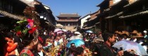
Entertainment in Shaxi Old Town, Dali
1.Allen`s Cafe, Address: Sideng Square (South of the old theater stage in the town square) 2.Trail Cafe Address:At the northeastern edge of the town square 3.Miss Mary Wine Bar(玛丽小姐吧) Address: 46 Sideng Street...
Ancient Culture of Shaxi Old Town in Dali
Shaxi Culture—the last Tea Horse Road market town Years ago, tea growers and horse traders met in markets along Yunnan’s Tea-Horse Road, an old trade route also called the...
History of Nuodeng Village in Yunlong County, Dali
Nuodeng is an exquisite village of Bai ethnic group in Yunlong County, west of Dali Bai Autonomous Prefecture, Yunnan Province. According to historical materials, Nuodeng enjoys a history of...

Ancient Culture of Nuodeng Village in Yunlong County, Dali
Nuodeng salt The salty water from the well is cooked till all water has evaporated and the clear white salt remains. This is done in the traditional way in...
Yunlong County History
“Salt horse ancient route” in Yunlong County Yunlong can be traced back to 2000 years ago. The town was a very important salt mining spot in that time. It...
Yunlong County Entertainment
In Yunlong County,if you want to spend your leisure time,don’t worry, you can find the the bars and clubs easily in Yunlong County. Maybe you are not interesting in bar...

Yunlong County Culture
The Nuodeng Bai’s Village in Yunlong Nuodeng Bai’s village, which is 7 km away from the Yunlong County and 174 km northwest of Dali city, is located in the...

Jianchuan County History
Jianchuan has a long history, splendid culture. As early as more than 3000 years ago, ancestors of Jianchuan complete the spanned by the history of the stone age to...

Jianchuan County Entertainment
In Jianchuan,if you want to spend your leisure time,don’t worry, you can find the the bars and clubs easily. Maybe you are not interesting in bar and clubs and do not...
Jianchuan County Culture
1. Ancestor of Bai people in Jianchuan The language of Bai belongs to the Yi branch of Zang-Mian Austronesian of the Chinese-Tibetan Phylum. They have also invented their own...

History of Jinghong
The town was founded as Chiang Hung (Cheli), by Tai king Phanya Coeng in 1180. Yuan Dynasty During the Mongol Yuan Dynasty in China, the Tai kingdom of Sipsongpanna...
Latest Articles
Contact Info
![]()
