-
- Home
- Yunnan Tours
Most Popular Yunnan ToursEssential Yunnan TripsFind Yunnan Tours by MonthFind Yunnan Tours by Duration
- Group Tours
Popular Yunnan Group ToursAll Yunnan Group Tours
- 1 Day Kunming Stone Forest Group Tour
- 1 Day Jade Dragon Snow Mountain Group Tour
- 2 Days Tiger Leaping Gorge Hiking Group Tour
- 4 Days Haba Snow Mountain Climbing Group Tour
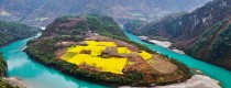
- 6 Days Yuanyang Hani Rice Terraces Group Tour
- 8 Days Kunming-Dali-Lijiang-Shangri-la Group Tour
- 8 Days Yunnan Chinese-Speaking Group Tour
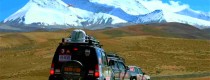
- 15 Days Yunnan-Tibet Small Group Tour
- Themes Tours
- City Tours
- Travel Guide
- Attractions
- Customize
 7 Days GolfingTour
 8 Days Group Tour
 8 Days Yunnan Tour
 7 Days Shangri La Hiking
 11 Days Yunnan Tour
 6 Days Yuanyang Terraces
 11 Days Yunnan Tour
 8 Days South Yunnan
 7 Days Tea Tour
 8 Days Muslim Tour
 12 Days Self-Driving
 4 Days Haba Climbing
 Tiger Leaping Gorge
 Stone Forest
 Yunnan-Tibet
 Hani Rice Terraces
 Kunming
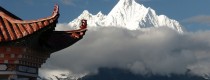
 Lijiang
 Shangri-la
 Dali
Dali
 XishuangBanna
 Honghe
 Kunming
 Lijiang
 Shangri-la
 Yuanyang Rice Terraces
 Nujiang
 XishuangBanna
 Spring City Golf
 Snow Mountain Golf
 Stone Mountain Golf
You Might Like
- 45 Days Singapore-Thailand-China (Yunnan, Sichuan, Tibet)-Laos Self-Driving Tour from Singapore

- 16 Days Best Yunnan Tea Tour along the Ancient Tea Horse Road
- 8 Days Best Yunnan Speed Train Tour-Kunming Dali Lijiang Shangri-La
- 10 Days Yunnan-Tibet Highway Overland Tour from Lijiang to Lhasa
- 6 Days Nujiang Grand Canyon Adventure with Bingzhongluo Hiking Tour
- 7 Days Yunnan Students Education and Family Tour with Ethnic Culture Experience
- 9 Days Yunnan Golf Tour to Kunming, Dali and Lijiang
- 6 Days Yunnan Minority Craft Culture Tour


Matihe River in Yiliang County, Kunming
Geographic Overview Origin: The Matihe River is a tributary of the Nanpan River (南盘江), originating in Malong District (马龙区), Qujing City (曲靖市). It flows south into Yiliang, quietly carving...
Mazongling Mountain Peak in Luquan County, Kunming
Mazongling (马鬃岭) rises to an elevation of 4,247 meters, located approximately 190 kilometers from Kunming (昆明). Nestled between Xueling (雪岭) at 4,344 meters and Jiaozi Snow Mountain (轿子雪山) at...

Xueling Peak (4334 Meters) of Gongwangshan Mountain in Kunming
Overview Xueling Peak (雪岭) is located between Jiaozi Snow Mountain (轿子雪山) and Jiulong Scenic Area (九龙风景区). Known as the “First Peak of Central Yunnan,” Xueling stands at an elevation...

Donglianhua Mosque in Weishan County, Dali
Donglianhua Mosque (东莲花清真寺) is an Islamic mosque located in Donglianhua Village (东莲花村), Yongjian Township (永建乡), Weishan County (巍山县), Yunnan Province (云南省). Originally constructed in the early Qing Dynasty, the...

6 Days XishuangBanna Tea Mountain Hiking Tour to Bada, Zhanglang, Xiding and Nannuo Tea Mountain
Jinghong-Menghai- Nannuoshan Mountain-Bada Town- Xiding Town-Jinghong

6 Days XishuangBanna and Puer Ethnic Culture Tour with Tea Culture and Ethnic Villages Discovery
Jinghong-Ganlanba-Menglun-Jinghong-Menghai-Xiding-Huimin-Jingmai-Menghai-Menghun-Jinghong

Guniushan Mountain in Dongchuan, Kunming
Introduction (简介) Guniushan Mountain (牯牛山) features steep cliffs and towering peaks often shrouded in clouds. On clear days, its lush greenery is visible from hundreds of miles away. The...

Mengga River in Yingjiang County, Dehong
Chinese Name:盈江县勐戛河 English Name: Mengga River in Yingjiang County, Dehong 勐戛河水系分布于盈江县县境西北山区,以勐戛河为干流构成河网系统,集水面积1073.43平方公里,产水量22.3亿立方米。勐戛河源于盈江县苏典乡东山一带山区,南向流经勐戛坝,接纳空树河、苦连皮河、邦别河,于子子凹鲁山东北麓折西向横贯苏典乡境,沿途接纳腊马河、苏典河、大竹河、勐劈河、小黑河、大黑河、龙江笼河、卡牟河、木文河与中缅界河 ...

Tianshengqiao Scenic Area in Shangrila, Diqing
The Tianshengqiao Scenic Area, also known as 香格里拉天生桥景区 in Chinese, is a breathtaking natural attraction in Shangri-La, Diqing. The area is renowned for its Tianshengqiao Hot Spring Resort and...

Xinzhai Village of Liujie Town in Jinning District, Kunming
Village Overview Xinzhai Village (新寨村) is a vibrant village located in Liujie Town (六街镇), Jinning District (晋宁区), Kunming City (昆明市). With a total population of 582 residents, it is...

Dahei Village of Xiyang Town in Jinning District, Kunming
Village Introduction Dahei Village (打黑村) is situated in Xiyang Yi Ethnic Township (夕阳彝族乡), Jinning District (晋宁区), Yunnan Province (云南省). It lies in the southern part of Xiyang Township (夕阳乡),...

Muzha Village of Xiyang Town in Jinning District, Kunming
木鲊村 (Muzha Village) is located in the 夕阳彝族乡 (Xiyang Yi Ethnic Township) of 晋宁县 (Jinning District), 昆明 (Kunming), Yunnan Province. It is situated in the northern part of Xiyang...
Latest Articles

Kunming Events Calendar
2025-08-05

Lijiang Festivals and Events in January
2025-08-04
Dali Festivals and Events in January
2025-08-04Contact Info

