7 Days GolfingTour
 8 Days Group Tour
 8 Days Yunnan Tour
 7 Days Shangri La Hiking
 11 Days Yunnan Tour
 6 Days Yuanyang Terraces
 11 Days Yunnan Tour
 8 Days South Yunnan
 7 Days Tea Tour
 8 Days Muslim Tour
 12 Days Self-Driving
 4 Days Haba Climbing
 Tiger Leaping Gorge
 Stone Forest
 Yunnan-Tibet
 Hani Rice Terraces
 Kunming
 Lijiang
 Shangri-la
 Dali
Dali
 XishuangBanna
 Honghe
 Kunming
 Lijiang
 Shangri-la
 Yuanyang Rice Terraces
 Nujiang
 XishuangBanna
 Spring City Golf
 Snow Mountain Golf
 Stone Mountain Golf
Dali Hiking Tour along The Ancient Tea-Horse Caravan Trail from Xizhou to Fengyu

|
| The hike and the greater surroundings |
*photos are in my Dali album on Flickr*
I’ve been living in Dali for a month now; it was about time I hit the mountain that lies directly behind my new home. Cangshan (苍山) is a striking range, rising steeply from the 2000 meter high Dali Plain to a series of peaks exceeding 4000 meters. The particular route I wanted to follow was one that I’d read about on my friend Ed’s website. I didn’t have many details about the route, but between the landmarks Ed described and Google Earth I had a pretty good idea how to go about it.

|
| A more detailed view of the full hike |
I originally thought I could do it in two days, but it ended up taking three. The hike can be nicely divided into three segments: the climb up the Wanhua River (万花溪) Valley, the high altitude Huadian (花甸) Valley, and the descent to the fertile Fengyu (凤羽) Valley.

|
| My route traced on a road map |
Here’s the path I took traced on a Chinese road map. Notice how it mostly passes through “blank space”, or roadless area.

|
| Fengyang village on the Dali Plain |
I started out on the Dali plain, in Xizhou town (喜州镇), about 20 km north of my home in Cai village (才村). A rickshaw brought me up to Fengyang village (凤阳村) at the base of Cangshan.

|
| The initial ascent, with two different routes: the road on the left, and the trail I chose on the right |
From here the Wanhua River runs up a canyon all the way to Huadian Valley. I could see on the satellite image that a road snakes its way up the left side of the river. But I also saw what looked like a foot trail on the right side, so I opted for that instead. I encountered some resistance just outside Fengyang as I started climbing the trail behind the village temple. A forest guard hounded me and told me to go back down. I didn’t want to argue with him, so I found another route, through some fields and up a steep slope, and evaded him.

|
| Cangshan’s famous rhododendron flowers were in full bloom |
An initial climb through the village cemetery brought me to a viewpoint from which I could see my trail heading into the canyon. It looked like smooth sailing. The flowers for which northwest Yunnan is famous, camelias (山茶花) and rhododendrons (杜鹃花), were beginning to bloom, splashing dabs of color in the otherwise green mass of pines and firs.

|
| This is typical of what the trail looked like. Most of the time it was deep in the cover of the forest, and only occasionally would emerge in a clearing to offer a view of the surrounding terrain |
After passing an abandoned stone house, the trail started getting more difficult. Lots of climbing, which disarmed me because I could see the road across the valley steadily climbing at an even grade, and here I was doing lots more work. I was never really in doubt that I was on an actual trail, but it clearly hadn’t been used in a while. I had to push my way through overgrown branches. My backpack was a big burden, constantly catching on some stick or other, and I’d often have to get down on my hands and knees. I moved very slowly and deliberately so as not to gouge out my eyes.
Having gotten a late start, and slowed down by this most tedious of trails, I had only covered 7.8 km by nightfall, and pitched my camp on a small outcrop 2800 meters high. This would be my first time camping in a bivouac sack instead of a tent. It’s a lot more lightweight, but it also doesn’t provide as much warmth or protection from the rain. The sky looked poised to open up, so I strung up a tarp to give me some cover. The wind was so fierce, though, that the tarp flapped incessantly, and I had to take it down. I barely got any sleep that night, what with the wind howling outside, and the not-quite-level ground which caused me to constantly slip downhill.

|
| This was the most frustrating part of the hike. Where the path makes a series of wild turns is where I tried to take a shortcut which ended up putting me in a dangerous canyon and having to backtrack |
Starting out the next morning the condition of the trail declined, and worse yet, it was still moving in the wrong direction! Finally, it crossed a gully and started back in the right direction. But as it got harder to follow, I took a wrong turn, and ended up deep down in the gully, looking for a shortcut, but finding myself stuck above a high precipice with no way around, forcing me to backtrack up the steep slope I’d just scampered down.

|
| Maybe I was just frustrated by the bad trail, but when I saw this it looked like a bad omen |
I found the real trail again, and it took me almost all the way down to the Wanhua River. At this point I just wanted to get across the river and up onto the road. But then my trail started heading up yet another tributary valley in the wrong direction!

|
| The incredibly detailed US Army map offers a clue as to why my trail seemed so wrong |
The best map I have of the area is one made by the US Army during World War II. It shows several trails (the black dotted lines) on Cangshan, including, it looked like, the one I was one. Studying this map, I believe I can see what my trail was up to. See the yellow arrow pointing to the trail over the ridge? That’s probably why my trail split off in what seemed like the wrong direction. I didn’t want to climb an extra ridge when the road was so close, so I tried to find a way along the river instead.

|
| An obstacle in the river valley |
Now I know from experience that following river channels is not always a good option for hiking, because they can be impossibly steep. That was the case now, where a vertical rock face stopped me from proceeding upriver. Fortunately, I was able to climb up and around the obstacle, and from there on out the river valley was easy to follow all the way to Huadian Valley and the main road.

|
| Once in Huadian Valley, the going got much easier. Here, my path follows the old stone road |
Huadian valley is nestled in between two parallel ranges of Cangshan, at an altitude just shy of 3000 meters. This 10 km long and 2 km wide valley, devoid of trees, is ideal grazing land, and I saw several flocks of sheep, goats, horses, and yaks.
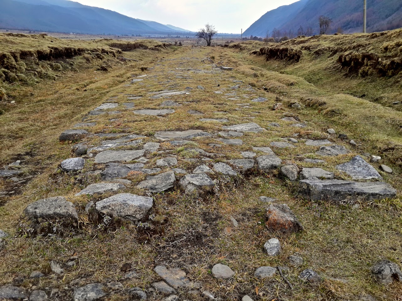
|
| The old stone road running through Huadian Valley |
I followed an old road in a nearly straight line through the valley. Composed of heavily worn stones, it looked like the ancient caravan roads which can still be found across Yunnan and can date back hundreds of years, but I was later informed this road in fact was only built in the 1950s. It is not a motorable road, but rather a path for horses and people to rely on during the rainy season.

|
| The only vehicle in Huadian Valley, this solitary bulldozer was hard at work leveling ruts in the roadway |
The road was broken in several places, and the earth along the roadway deeply rutted and eroded. A lone bulldozer was in the process of leveling these ruts, presumably to make the path accessible for 4WD vehicles.

|
| Huadian valley is the highest of its kind in Dali |
This pasture at 3000 meters is quite unusual for Dali, the majority of which sits closer to 2000 meters. It’s the only place in Dali where yaks are raised. This type of environment is far more typical of Shangri-La (Diqing) further to the north. Huadian is inhabited by a small population who look after the herds. This population is not as big as it once was, however, and I saw lots of old stone houses in states of disrepair.

|
| Huadian valley scenery |
In English, Huadian means Flower Valley. The valley was plenty pretty for me, what with its golden grasslands and forests of green and red illuminated by rays of sun. But June, I’m told, is when the valley really comes alive, in a carpet of technicolor flowers.

|
| Crops of the medicinal plant farm |
In late afternoon I reached the Medicinal Plant Farm (药材场), a state-owned relic of 1950s. A complex of several buildings, it hosts both the employees who grow high altitude medicinal plants for export, and the local government office. It also has dormitories which it rents out to travelers like me. I’d hiked 12 km, and was looking forward to sleeping in a real bed so I stopped here for the night. I joined the ten or so people there for dinner, during which I was befriended by a policeman, who every month spends two weeks here and two weeks down in Dali. He showed me photos of Huadian last December, when the valley was buried under several feet of snow.
Murals on the wall at the farm depicted seven of the medicinal plants grown. I wrote them down, and was later able to find the Latin names of four of them:
山嵛菜 Eutrema yunnanense
红豆杉 Taxus chinensis
岩白菜 Bergenia purpurascens
水冬瓜 Alnus cremastogyne
龙抱桂 (No Latin name found)
鸡肉叁 (No Latin name found)
黄杜丹 (No Latin name found)
The most interesting is Eutrema yunnanense, or Japanese horseradish, used to make wasabi. Japanese horseradish grown here in Huadian valley is shipped to Dali by horse, and then exported to Japan!

|
| The route south of Huadian Valley |
I slept much better that night, and woke to a sunny day, ready for another day of hiking. The only bit of trouble I encountered was when three ferocious dogs surrounded me, and my usual trick of feigning to throw a rock didn’t work. I blew my emergency whistle, and a man appeared and chased off the dogs, then pointed me in the direction of the trail. The trail this time was very easy to follow, not at all overgrown like the previous days’ trail, passing through lovely forests with lots of wild camelia and rhododendron.

|
| I was passed by a 150-horse caravan on its way from Laping to Huadian |
Mid-morning I was passed by a team of 20 or so horses. I thought that was exciting enough, but over the next two hours I kept encountering more and more of the horses. Each time a new group passed, I gained bits of information. Altogether there were 150 horses in their party. They kept telling me they were from “Lanping”, which confused me, because Lanping (兰坪) is over 100 km and several mountain ranges away. It turns out I was misled by their accent, and they were actually from Laping village (腊坪村), just over the next ridge. They were going to Huadian, in order to collect some sort of timber they called “dongge” (I never figured out what this was, and I may have been mislead once again by their accent). It was a pleasant discovery to find that in this part of China transportation is still as its been for hundreds of years, and horse caravans are still very much alive.

|
| This red earth fields were being prepared for the summer crop of beans |
I came to an area of broad terraced fields extending down the mountain slope, the earth a deep red tint. Farmers, presumably from the same village as the horse caravan, were busy tilling the fields with oxen. They told me they will soon plant them with “big white beans” (大白豆). I’m thinking cannellini?

|
| Up on the red earth terraced ridge, the main trail continues on to Laping, but I took a lesser trail down into the Fengyu Valley |
My destination was the town of Fengyu (凤羽镇) in the valley of the same name, but I was still high above it on the ridge. A farmer pointed me towards a small trail leading down through the pine forest. It emerged in a narrow spur valley, an idyllic place with peach and apple trees. At the bottom of this spur valley was a small temple and entrance to the Qingyuan Cave (清源洞). I got out my flashlight and went about 200 meters deep inside the expansive cave. With no infrastructure or idea how much deeper it went, I went back outside, where I found spring emerge from the ground, flowing with crystal clear water.

|
| The Qingyuan spring emerges here just below the entrance to the cave of the same name |
From here I was back in civilization for the first time in three days, following a paved road past tidy Bai ethnic villages through the richly cultivated Fengyu valley.

|
| My path through Fengyu Valley |
I had another 8 km to go before I reached Fengyu town. I expected to be able to hitchhike this last stretch, but the opportunity never came; the only vehicles that past me were going the opposite direction. Although I was tired, I didn’t too much mind the walk through this most beautiful of valleys.

|
| Winter crops of wheat and beans paint Fengyu Valley in rich verdant shades |
Up on the ridgeline, the red earth soil is planted just once a year, in the summertime. But here in the valley, two annual crops are possible—rice or corn in the summer, and wheat, beans, or canola in the winter.

|
| The satellite view of Fengyu Valley is spectacular |
The view from the ground was pretty enough, but the best view of Fengyu Valley is undoubtedly from satellite. The odd-shaped fields and varied crops in their different stages of growth paint a gorgeous image from above.
Finally in Fengyu town, after hiking 20 km from Huadian, I got a minivan ride to Eryuan County Seat (洱源县城), where I got a bus back to Dali. If I ever do this hike again, I probably will take the main road from Fengyang, rather than the old trail. Although that trail was an adventure and took me through some wild forests, it was more than I’d bargained for. Next time, from the ridgeline I would also chose the other path, the one to Laping village, where the horses came from, and from there down to Yousuo town (右所镇).
http://matthartzell.blogspot.com/2014/04/cangshan-mountain-three-day-hike.html