 7 Days GolfingTour
 8 Days Group Tour
 8 Days Yunnan Tour
 7 Days Shangri La Hiking
 11 Days Yunnan Tour
 6 Days Yuanyang Terraces
 11 Days Yunnan Tour
 8 Days South Yunnan
 7 Days Tea Tour
 8 Days Muslim Tour
 12 Days Self-Driving
 4 Days Haba Climbing
 Tiger Leaping Gorge
 Stone Forest
 Yunnan-Tibet
 Hani Rice Terraces
 Kunming
 Lijiang
 Shangri-la
 Dali
Dali
 XishuangBanna
 Honghe
 Kunming
 Lijiang
 Shangri-la
 Yuanyang Rice Terraces
 Nujiang
 XishuangBanna
 Spring City Golf
 Snow Mountain Golf
 Stone Mountain Golf
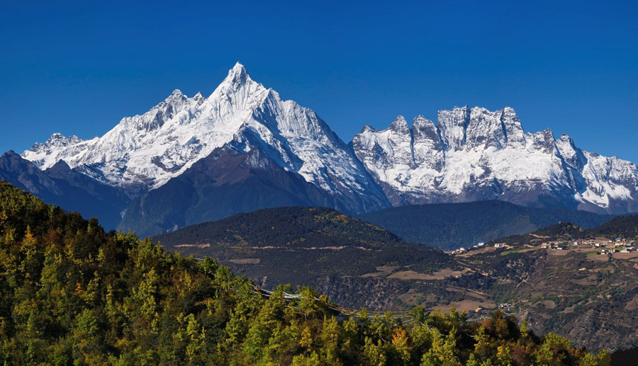
Meili North Slope (Meili Beipo) of Meili Snow Mountain
Chinese Name: 梅里北坡
English Name: Meili North Slope
Type: Points of Interest & Landmarks, Hiking & Trekking
Best Time: October to February Next Year
Recommended Visiting Hours: 2~7 Days
Opening Hours: All Day
Ticket: 20 RMB trash collection fee
Location: About 849 kilometers away from Kunming City.
Why is Meili North Slope so special?
Shangri-La is a beautiful and dreamlike paradise in the novel, Lost Horizon by British author James Hilton. In English, Shangri-La represents a distant and charming place, while in French it means heaven on earth, and in Spanish it means paradise. In Chinese, it is interpreted as an idyllic place away from the world. In the novel, Shangri-La is located on the border between Tibet and China. There are mysterious and peaceful Blue Moon Valley, desolate snowfields, snow-capped mountains towering like pyramids into the clouds, misty forests shrouded in clouds, lamaseries and so on. It seems to depict the Meili Snow Mountain, which is concealed deep within the foothills of the Himalayas.
Meili North Slope is located at the northern foot of the uninhabited Meili Snow Mountain. It is more primitive and secluded than Hiker’s Paradise, Yubeng Village(雨崩村). Therefore, almost no hikers have set foot there. Some people say it is the last secret of Meili Snow Mountain, and the closest place to the God of Kawagebo Mountain, while others say it is the prototype of the mysterious and ancient snow country Shangri-La in the Lost Horizon.
Introduction
Location
Meili Snow Mountain is located at the junction of Deqin County(德钦县) in Diqing Tibetan Autonomous Prefecture,Yunnan and Chayu County(察隅县) in Linzhi City, Tibet. It is 849 kilometers away from Kunming and lies in the Three Parallel Rivers UNESCO World Heritage Site. It connects with Adonggeni Mountain(阿冬格尼山) in Tibet to its north and Biluo Snow Mountain(碧罗雪山) to its south. There are 13 peaks that have an average height of more than 6000 meters (20000 feet) in the Meili Snow Mountain.
Meili North Slope refers to a group of peaks on the north side of Meili Snow Mountain. From east to west, they are Nairidingka Peak (奶日顶卡峰, 6379 meters), Mangkuanglaka (芒框腊卡峰, 6040 meters), Cuguilaka Peak (粗归腊卡峰, 509 meters) and several other mountain peaks.
Main Attractions
● Pojun Camp (坡均营地)
Pojun Camp means the valley where immortals reside in Tibetan language. In Pojun Camp, snow mountain is in front of us, glacier is close at hand. Throughout history, individuals have climbed mountains to gather medicinal plants. Due to the long distance, they had to stay on the mountain and eat and live there for years, eventually forming a camp. In the depth of Meili, people still lived off of gathering resources such as chopping wood, carrying water, building fires and roasting meat. Come here, you can appreciate how human childhood is spent.
● Nairidingka Glacier(奶日顶卡冰川)
The Nairidingka Glacier is located on the side of Nairidingka Peak. Standing at the Pojun Camp, a pale blue huge glacier stretches out in front of you, making one feel like entering a crystal palace in a myth. The scenery is magnificent and grand, and it is not inferior to any glacier among China’s top six most beautiful glaciers.
● Lion Sacred Mountain(狮子座神山)
Lion Sacred Mountain is also known as Cuguilaka Peak or Kawagebo II Peak, with an altitude of up to 6,509 meters, second only to Kawagebo Peak in the Meili Snow Mountain area. It is the second highest peak in the area and is revered by Tibetan Buddhist believers as a deity for practicing at the Taizi Palace.
● Meili Shuang Lake(梅里双湖)
Meili Shuang Lake (officially named Shuang Lake, but renamed Meili Shuang Lake to distinguish it from the Shuang Lake in Tibet) is a rare pair of glacial lakes formed by twin snow-capped mountains. The lake water is usually crystal clear and blue like two blue gems embedded in the ice field. In winter, they are frozen and disappear without a trace, adding to their serene and mysterious beauty compared to other glacial lakes that may be affected by landslides or avalanches. They are also known as Tianchi (Heavenly Lake) of Meili Snow Mountain.
● Mangkuanglaka Peak(芒框腊卡峰)
Mangkuanglaka Peal is located on the west side of Nairidingka Peak, consisting of two parallel and majestic snow peaks. It has an altitude of 6040 meters. At the Pojun Camp, you can observe the spectacular natural phenomenon of the sunrise over Mangkuanglaka Peak up close.
● Pojiang Camp(坡将营地)
The Pojiang Camp, also known as the Pojiang Cattle Ranch, is a large and beautiful natural ancient pasture. In summer, there are lush green grass and sheep and cattle on the hills. In autumn, everything becomes desolate but presents a colorful scene. In winter, it is frozen for miles with snow drifting.
● Yunnan-Tibet Border Pass(滇藏界垭口)
Yunnan-Tibet Border Pass is the boundary passageway from Yunnan to Tibet. It feels like walking on a heavenly road when you come here. It is an excellent location for viewing several snow-capped mountains in the northern slope of Meili, making it known as the most beautiful natural observation deck of Meili Snow Mountain and the first dangerous pass in Meili Snow Mountain.
Trails at Meili North Slope
There are many hiking trails around Meili Snow Mountain, including several on the north slope. However, the two most popular routes are the Small and Large Circles (also known as C-line) on the north slope of Meili. Both routes start from Yagong Village(亚贡村) and reach Yunnan-Tibet Border Pass(滇藏垭口), but the Large Circle or C-line continues into Tibet while the Small Circle stays in Yunnan and returns to Yagong.
Non-Chinese individual hikers cannot complete the Large Circle or C-type path without a Tibet travel permit. You need to apply for a permit first and bring an authorized guide with you for trekking. As we focus on personal outdoor adventure activities, we will only introduce the small circle route that can be easily completed by self-help!
There are several options available for camping and determining how much distance to cover each day. The trek always begins in Yagong Village, which is the last accessible location by road. From there, the path continues through Zhangjia Camp(涨价营地), Zhulin Camp(竹林营地), and Pojun Camp(坡均营地). After Pojun, cross over Ciding Pass(次丁垭口) at 4770 m to enter a parallel valley and continue on to Pojiang Camp(坡将营地). From there, you can either take a day hike to Yunnan-Tibet Border Pass() at 5200 m or head back towards Yagong Village(亚贡村).
5 Days: The most common Meili North Slope Trek
This is the usual hiking route that individuals refer to as the Meili North Slope (small circle trail). Nearly all of the other hikers we encountered adhered to this itinerary. The estimated trekking times listed below are approximate and based on our pace, so your speed may vary.
The first day is relatively short, allowing you to arrive at Yagong Village(亚贡村) in the morning, start your journey at noon, and comfortably reach your destination in the afternoon. The second day is also relatively short but with a choice: leave all heavy equipment at the campsite and hike to the ice lake in the afternoon.
- D1: Yagong Village – Zhangjia Camp (5 hours, 9km, 500m elevation gain)
- D2: Zhangjia Camp – Pojun Camp (4 hours, 11km, 600m elevation gain)
plus optional hike to Ice Lake (4 hours roundtrip) - D3: Pojun Camp – Ciding Pass – Pojiang Camp (6 hours, 6km, 650m elevation gain)
- D4: Day hike to Yunnan-Tibet Border Pass (6 hours, 10km, 1000m elevation gain)
- D5: Pojun Camp – Yagong Village (8 hours, 18km, 700m elevation gain)
4 Days: Long first day
The route is mostly the same as usual, except that the first two days are combined into one. This means you’ll need to depart Yagong Village early (and may need to spend the night there). Basic lodging in Yagong is offered at a cost of 50RMB per night for a bunk bed, but it’s unclear whether foreigners are permitted to stay there.
- D1: Yagong Village – Pojun Camp (10 hours, 20km, 1400m elevation gain)
- D2: Pojun Camp – Ciding Pass – Pojiang Camp (6 hours, 6km, 650m elevation gain)
- D3: Day hike to Yunnan-Tibet Border Pass (6 hours, 10km, 1000m elevation gain)
- D4: Pojun Camp – Yagong Village (8 hours, 18km, 700m elevation gain)
4 Days: Skipping the Yunnan-Tibet Border Pass
Another option is to skip Day 4 of the main route and only do the circle trail. However, keep in mind that the views on the trail to the border pass are breathtaking, so consider carefully before deciding to skip it!
- D1: Yagong Village – Zhangjia Camp (5 hours, 9km, 500m elevation gain)
- D2: Zhangjia Camp – Pojun Camp (4 hours, 11km, 600m elevation gain)
plus optional hike to Ice Lake (4 hours roundtrip) - D3: Pojun Camp – Ciding Pass – Pojiang Camp (6 hours, 6km, 650m elevation gain)
- D4: Pojun Camp – Yagong Village (8 hours, 18km, 700m elevation gain)
3 Days: Long first day and skipping Yunnan-Tibet Border Pass
If you have limited time, consider doing a longer first day and skipping the border pass to complete the circle in three days. There are other options as well, such as staying at Zhulin Camp which is only half an hour uphill from Zhangjia Camp on the first day or staying at the Unnamed Camp (which we couldn’t identify by name but is likely Dala Camp 达拉营地) on the last day. Lastly, you could also trek counterclockwise, which will be discussed below.
- D1: Yagong Village – Pojun Camp (10 hours, 20km, 1400m elevation gain)
- D2: Pojun Camp – Ciding Pass – Pojiang Camp (6 hours, 6km, 650m elevation gain)
- D3: Pojun Camp – Yagong Village (8 hours, 18km, 700m elevation gain)
Clockwise or Counterclockwise ?
This trek is part of a Tibetan-Buddhist Kora, a type of circumambulation around a sacred object (in this case the Meili Snow Mountain, or a part of it). The tradition for Buddhists is to walk in a clockwise direction, and many loop hikes in the region are outlined this way. Most hikers follow the Meili North Slope trek in a clockwise direction as well, but it’s not required. It’s possible to do the trek counterclockwise, but it includes a steep ascent and remains at high altitude until Pojiang Camp. Therefore, it’s only recommended if you’re already acclimatized to high altitudes.
Camping off the campsites
According to regulations, you must camp at the designated campsites indicated on the map above. Although this rule is not strictly enforced, local guides may inform you that camping outside of these official sites is prohibited if your chosen location is too far away. It’s important to note that the valley walls are steep and often covered in forest or rock debris, making it difficult to find a suitable spot for camping outside of the official campsites in most areas. Therefore, it’s recommended to stay within or near the official campsites.
Section 1: Yagong (亚贡) to Zhangjia Camp (涨价营地)
Upon arrival in Yagong, gather your equipment and embark on an incredible trek! Proceed out of the village along a dusty and level dirt road into the valley. After approximately 2km, you will come across a quarry (采石场) where locals are storing and processing stones for construction projects. The beginning of the trail is located directly behind the quarry on the left side of the valley wall, and is indicated by a sign (徒步起始点). The path is easily visible and generally follows upstream along the river in the valley, crossing it several times via wooden bridges. As most of this forested trail runs through the bottom of the valley, it provides ample shade.
Once you arrive at a clearing in the forest containing an abandoned wooden hut, chopped firewood, and some wooden benches, you have arrived at Zhangjia campsite. There is enough room to pitch a tent in front of the wooden hut as well as behind it and on the right side of the valley. The stream runs directly next to the campsite, providing easy access to water for cooking and washing. Additionally, if you continue along the trail for another 30 minutes, you will reach Zhulin (竹林营地) camp which is larger and more popular than Zhangjia. However, when we visited there were many people heading towards Zhulin so we opted for a quieter stay at Zhangjia.
Section 2: Zhangjia Camp (涨价营地) to Pojun Camp (坡均营地)
After finishing breakfast, dismantle the tent and proceed along the stream until you reach Pojun. Along the way, you will come across Zhulin camp (竹林营地), which is named after its location in a dense bamboo forest. As you continue to climb, the vegetation becomes less dense and there are more bushes than tall trees. This provides an opportunity to catch a glimpse of one of Meili Snow Mountain’s majestic peaks.
We pitched our tent in the open meadow at around noon and then went for a lightweight afternoon hike (without backpacks) to Ice Lake (冰湖). The route extension to Ice Lake is marked on this GPS trace from 2bulu(两步路) and should take approximately 4-5 hours for the round trip.
Section 3: Pojun Camp (坡均营地) to Pojiang Camp (坡将营地)
You will traverse Ciding Pass (次丁垭口) at an altitude of nearly 4800m to enter the adjacent valley. Approximately 15 minutes after departing from Pojun Camp, you will arrive at a level grassland featuring a small lake. The transparent water of this lake impeccably mirrors the snow-capped mountains situated in its backdrop.
At the lake, the trail takes a right turn and continues to ascend steeply. A wooden sign with the words 次丁垭口 marks the way. As you climb, there are stunning views of Meili’s northern slope behind you – arguably some of the best views on the entire trek. Be sure to take regular breaks and soak in the panoramic scenery.
After climbing for approximately half the distance, you will come across a visible mountain stream where you can replenish your water reserves. This is the final chance to do so before arriving at Pojiang Camp, therefore ensure that you refill adequately!
After crossing the pass, there is a steep descent to Pojiang Camp. In the past, there was an Pojiang Camp located on the grasslands uphill from today’s campsite, but camping there is no longer allowed in order to protect vegetation (apparently it’s a breeding ground for the famous caterpillar fungus called 虫草 in Chinese).
Pojiang Camp is also a fairly large settlement with at least 20 huts, some of which were inhabited by herdsmen and farmers. However, don’t expect to be able to buy anything as there are no shops. Find a good spot to set up your tent as you’ll be staying two nights. We camped on the northern wall of the valley, away from the huts. There’s a stream flowing through the settlement that serves as a water source.
Section 4: Day-hike to Yunnan-Tibet Border Pass (滇藏垭口)
The journey to the Yunnan-Tibet Border Pass and back takes 6-8 hours, depending on how fast you go. You will need to climb up 1000m from Pojiang Camp (which is at an altitude of 4200m) to reach the pass at an altitude of 5200m. Fortunately, you can leave most of your luggage and camping gear at the campsite. However, please note that the trail may not always be clearly visible during this part of the trek, so it’s a good idea to check your map and GPS trace periodically.
On the journey, there is only one small stream where you can refill your bottles. Therefore, it is important to take advantage of this opportunity and carry enough water with you! As you ascend higher, the vegetation becomes less dense until there are only rocks and dust at approximately 5000m.
In the final moments of the climb, it becomes extremely difficult as you ascend a steep incline made up of small rocks and sand that constantly slip beneath your feet. However, once you catch sight of the pole and prayer flags indicating the pass, you know that you have succeeded! Although there should be stunning views of both Yunnan’s Meili range and other towering peaks in Tibet from this vantage point, we were unfortunately shrouded in clouds and unable to see anything. The three sides of the pole marking the pass are engraved with different words facing different directions; therefore, choose whichever message resonates with you most for your victory photo! Additionally, other hikers were quick to notice that one character on the pole was spelled incorrectly – instead of 海拔 (meaning “altitude”), it read 海泼 (which roughly translates to “ocean sprinkle”).
We brought our gas stove and some tea leaves to the pass, which proved to be a worthwhile decision. We enjoyed a relaxing break at the highest point of the trek, waiting for the weather to clear up while sipping on hot tea. To return to camp, simply descend via the same trail you used to ascend. The big circle trail or C-trail would lead you across the pass and into Tibet; however, this is not an option for individual non-mainland hikers.
Section 5: Pojiang Camp (坡将营地) to Yagong (亚贡)
Wake up early on the final day as it is the longest part of the journey, covering 18km and taking approximately 8 hours to complete with an elevation gain of 600m. Once you have packed your belongings and left Pojiang behind, you will begin by descending through a stunning forest for a short while. However, this descent won’t last long as you’ll soon start ascending again and climb to around 4400m for the next few hours.
The path is exceedingly picturesque and offers stunning vistas of the Yagong valley ahead, as well as views of snow mountains in the rear.
After a couple of hours, you will come across an uninhabited settlement consisting of two or three dilapidated huts which is likely another camping area known as Dala Camp (达拉营地). Following that is Dala Pass (达拉垭口), the highest point on this part of the journey at 4360m. From there, you will begin your descent towards Yagong. Eventually, you will spot Yagong village in the distance and realize that it’s still quite far away and that you still have to descend 1300m.
Next, there is a sharp decline through thick woods that commences until you arrive at the base of the valley and proceed alongside a stream all the way back to the primary valley. This particular stream marks the initial water source on this route, so it’s recommended to bring sufficient water from Pojiang to last until reaching here (approximately 5 hours after departing camp).
How to Get There
Meili Snow Mountain is located in the far northwest region of Yunnan Province, which is situated in southwestern China. The nearest major settlement to Meili Snow Mountain is Deqin County, while the closest airport to the mountain range is Diqing Shangri-La Airport, which can be found in Shangri-La/Zhongdian. For those seeking more flight options and connections, Lijiang Airport can also be considered as it’s only two hours south of Shangri-La.
The trek of Meili North Slope always begins in Yagong Village(亚贡村), which is the farthest point accessible by road. Yagong Village is about an hour northwest of Deqin. There are three transportation options to reach Yagong Village: taking a bus, driving yourself, or hiring a private car. All of them are starting from Shangri-La.
By Bus and Chartered Car
Taking the bus does not directly lead to Yagong Village. There are multiple buses from Shangri-La Bus Station to Feilaisi, costing 64 yuan. From Feilaixi, you can charter a car to Gushui Village. Tell the driver that you want to go to the Meili North Slope. If the driver does not want or allow to continue to Yagong Village, please switch to a local car waiting in the valley and take hikers to Yagong (there should be some drivers standing nearby).
By Self-driving
The G214 road between Shangri-La and Deqin is in good condition, but it is a winding mountain road that spans 160km. There is one police checkpoint located in Benzilan where all passengers’ IDs are checked. The journey from Shangri-La to Deqin typically takes around 3-4 hours. Continuing northbound on the G214, you will pass Feilaisi monastery which offers stunning views of the Meili Snow Mountain range. After Feilaisi, the road remains paved but its condition deteriorates with many potholes and some rockfall; however, it can still be driven with a regular car without requiring high ground clearance or an off-road vehicle.
Before arriving at Gushui, there’s a bridge crossing the valley where you should turn left onto the road leading to Yagong village. At a small checkpoint along this single-lane concrete road up the mountain (which has countless bends), hikers must register for their hike and pay a trash collection fee of 20 yuan.
Yagong Village sits at an elevation of 3000m after ascending from 2000m at the valley bottom across numerous bends on this winding mountainous route that eventually ends in Yagong Village itself – where parking is available for those who wish to begin hiking. The entire drive from Shangri-La to Yagong takes approximately five to six hours without any breaks included. For reference purposes, Yagong Village’s coordinates are listed as being situated at 28.60841/98.72375.
By Chartered Car
You can also hire a private car all the way. Ask the owner of your hostel/hotel for assistance in arranging this.
Recommended Meili North Slope Tours
Top 3 Meili Snow Mountain Hiking tours chosen by most customers to explore Meili Snow Mountain in the best way. Check the detailed itinerary, or tailor your own trip now with us. We provide some tour routes for tourists to choose.
7 Days Meili North Slope Trekking Tour from Shangri La
4 Day Meili Snow Mountain and Yubeng Village Hiking Tour from Shangri-La
2 Days Meili Snow Mountain and Yubeng Village Hiking Tour from Shangri-La
Useful Travel Tips
1. Best Season
The optimal periods for hiking the Meili North Slope are late autumn (October to November) and spring (March to May). Although winter (December to February) offers clear skies, it can be extremely cold. It is best to avoid the rainy season in July and August. For additional information, please refer to the average yearly weather in nearby Deqin on Weatherspark and check the mountain weather forecast for Kawagebo Peak at your altitude (4000 m or 5000 m).
2. GPS Traces
You can access high-quality GPS tracks for this trek by searching for “梅里北坡” on either of China’s popular outdoor apps, 两步路 (2bulu) and 六只脚 (foooooot). The GPX trace is available for the entire trek or daily snippets.
And here is the annotated trace (with English markers indicating the campsite, as seen in the Google Earth screenshot above) in KML format. You are welcome to upload it to Google Earth and virtually explore the route!
3. Tickets
No admission ticket or permit fees are necessary for hiking the Meili North Slope. However, a 20 RMB fee for trash collection must be paid at the registration checkpoint.
4. Registration, Trekking Permit and Trash Fee
On the way to Yagong Village, there is a registration checkpoint for all hikers. At the checkpoint, you will need to complete some paperwork:
- Sign the “Exemption Agreement for Hiking Exploration on the North Slope of Meili” (梅里北坡徒步探险免责协议书), which basically states that you are responsible for yourself.
- Read and sign a forest fire prevention form.
- Scan a QR code with WeChat to check into the national park (and scan again when leaving to check out).
- Pay a mandatory trash collection fee of 20 RMB per person.
- Get your itinerary approved and stamped, including length of stay, chosen campsites, and heavy/light gear.
The personnel manning the checkpoint were amiable and aided us in completing all the paperwork (as they only spoke Chinese). Additionally, they assisted us in drafting an itinerary with essential details since we had only planned it mentally and digitally on our phones’ maps. It seems that this itinerary must be carried at all times, and it should include the following information:
- The location where you intend to camp on specific dates
- The number of individuals in your group
- Your departure date from the national park
- Whether you have heavy or light gear (heavy means carrying it yourself, while light entails using a horse porter)
5.Guide & Horse Rumor
Prior to embarking on the trek, we received information from various sources including a local guide, a hostel owner in Shangri-La and other hikers that hiring a guide and horse porter (马帮) was mandatory for this particular trek. This caused us concern as we were unsure if we would be allowed to undertake the trek independently. Some individuals even claimed that they knew someone who had been denied entry for attempting an individual trek. However, the checkpoint officer consistently stated that there was no such requirement – it was not necessary to hire a guide or horse porter and it was perfectly acceptable to undertake the trek individually. Anyone attempting to convince you otherwise is likely trying to scam you; do not listen to their claims or entertain their advances. The rumor about requiring guides and horse porters has been spread by greedy people but it is just that – a rumor with no basis in truth. During our hike, we encountered several other independent hikers undertaking the same trek.
6. Essential Equipment
- Clothing:
- Assault suit: 1 set (waterproof, breathable)Fleece suit: 1 set (with spare fleece pants)
- Down jacket: 1 rib-shaped thin one and 1 thick camp down jacket (fluffy degree above 500, filled with 120G of down in July and August, and filled with over 150G of down in June, September, and October)
- Quick-drying suit: 1 set
- Sweat-wicking underwear: 2 sets (for changing)
- Hiking shoes: waterproof, high-top (check for degumming before wearing)
- Outdoor moisture-absorbing sweat socks: 5 pairs
- Sun hat: 1 piece
- Warm hat: windproof and warm
- Sunglasses
- Gloves:windproof warm soft shell gloves – a pair
- Magic headscarf:one or two pieces
- Snow cover:a pair.
- Camping:
- Headlamp: 2 spare batteries
- Trekking poles: 1 pair
- Small backpack: 1 (25-30 L, for carrying personal warm clothing, rain gear, headlamp and water for the day’s journey)
- Navigation:
- Camera
- Mobile phone
- Battery
- Power bank
- Food & Drink:
- Camp stove + fuel canister
- Water bottle (refill from mountain streams)
- Water purification method (chemical tablets, mechanical filter, UV light – your choice)
- Others:
- First aid kit
- Passport/ID card
- Toiletries
