 7 Days GolfingTour
 8 Days Group Tour
 8 Days Yunnan Tour
 7 Days Shangri La Hiking
 11 Days Yunnan Tour
 6 Days Yuanyang Terraces
 11 Days Yunnan Tour
 8 Days South Yunnan
 7 Days Tea Tour
 8 Days Muslim Tour
 12 Days Self-Driving
 4 Days Haba Climbing
 Tiger Leaping Gorge
 Stone Forest
 Yunnan-Tibet
 Hani Rice Terraces
 Kunming
 Lijiang
 Shangri-la
 Dali
Dali
 XishuangBanna
 Honghe
 Kunming
 Lijiang
 Shangri-la
 Yuanyang Rice Terraces
 Nujiang
 XishuangBanna
 Spring City Golf
 Snow Mountain Golf
 Stone Mountain Golf
Jinsha-Yangtze River in Yunnan Province
The Jinsha River, as the upper reach of the Yangtze River, originates at the junction of Qinghai and Sichuan provinces, specifically at Zidomenda (Xiedu Village, Duoxian County, Yushu Prefecture), and flows until its confluence with the Yangtze River main stem at Hejiangmen (Sanjiangkou, Hejiangkou) in Cuiping District, Yibin City, Sichuan Province. Within Yunnan, the Jinsha River basin spans Deqen Tibetan Autonomous Prefecture, Lijiang City, Dali Bai Autonomous Prefecture, Chuxiong Yi Autonomous Prefecture, Kunming City, Qujing City, and Zhaotong City, covering 23 counties (cities, districts).
Geographic and Hydrological Features
Source and Course
- Origin: The Jinsha River originates from Gyalmo Ngulchu Snow Mountain in Qinghai Province, flowing through Tibetan Plateau and eastern Tibet before entering Yunnan.
- Course: It spans across Deqen Tibetan Autonomous Prefecture, Lijiang City, Dali Bai Autonomous Prefecture, Chuxiong Yi Autonomous Prefecture, Kunming City, Qujing City, and Zhaotong City in Yunnan, covering a vast area of 23 counties and districts.
Physical Characteristics
- Length: The river’s main stream from source to its confluence with the Yangtze River spans approximately 3,481 kilometers (though some sources cite 3,364 kilometers).
- Drainage Area: Covers around 502,000 square kilometers, accounting for 26% of the Yangtze River basin.
- Gradient and Flow: With an average gradient of 17.2‰ in certain sections, it flows swiftly with an average annual flow rate of 4,750 cubic meters per second, primarily sourced from precipitation and ice melt.

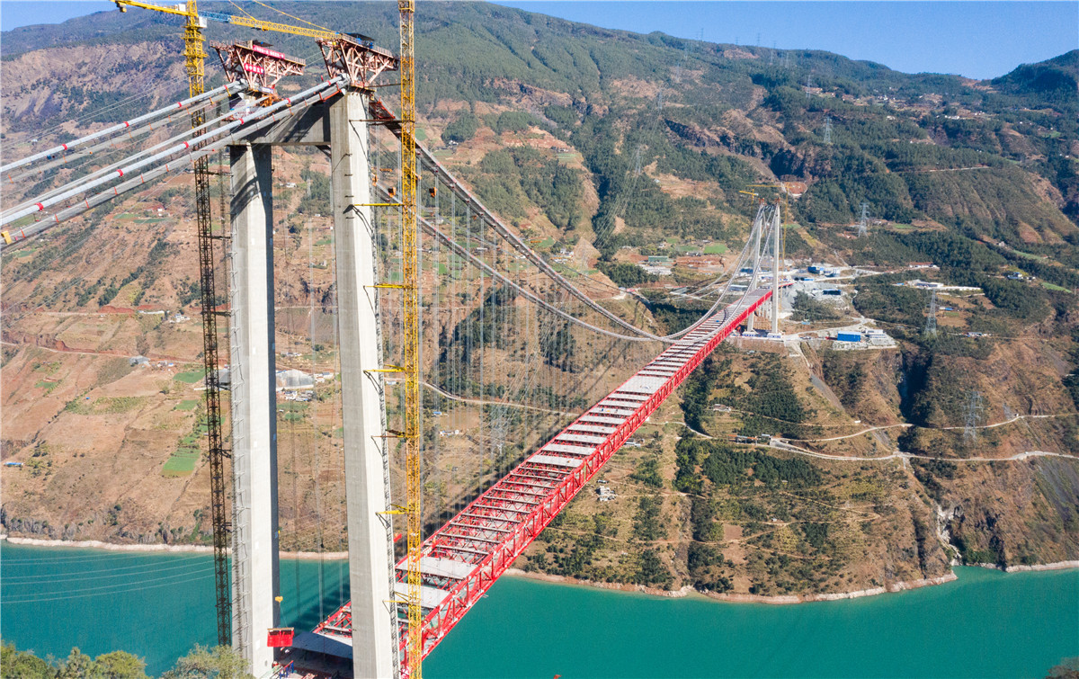
 The Jin’an-Jinsha River Bridge in Yunnan
Cultural and Historical Significance
Name Evolution
- Historical Names: Known as Heishui in ancient texts like the Book of Yu Gong, it evolved through various names like Shengshui and Yanshui during different historical periods.
- Modern Name: During the Song Dynasty, it became widely known as the Jinsha River due to the abundance of gold sand found along its banks.
Strategic Importance
- Historical Events: The river has played a crucial role in Chinese history, notably during the Red Army’s Long March and other military movements due to its strategic crossings.
Regional Sections and Landmarks
Upper Section (Deqen to Lijiang)
- Geography: Characterized by steep mountains and deep valleys, including the famous Tiger Leaping Gorge, known for its dramatic cliffs and rapids.
- Cultural Sites: Includes Shangri-La and Lijiang, offering rich cultural experiences amidst breathtaking natural beauty.
Middle Section (Lijiang to Dali)
- Features: Passes through Dali Prefecture, offering a mix of ancient towns, lakes like Erhai, and cultural heritage sites.
Lower Section (Dali to Zhaotong)
- Hydroelectric Potential: Known for its steep gradients and significant hydroelectric power potential, contributing over 40% of the Yangtze River’s hydroelectric resources.
Challenges and Conservation Efforts
Environmental Impact
- Sedimentation: Significant sediment load impacts downstream ecosystems, particularly at the Yichang station on the Yangtze River.
- Conservation: Efforts underway to balance hydroelectric development with environmental conservation and sustainable water management practices.

The Jinsha River, known for its yellowish sandy soil, is also called Shengshui, Yanshui, and Lushui. It serves as the boundary river between Sichuan and Tibet. The source of the Jinsha River (and hence the Yangtze River) was officially determined in the 1970s to be the Gyalmo Ngulchu Snow Mountain, a main peak of Tanggula Mountains in Qinghai Province. The main tributary, Tuotuo River, originates from an unnamed mountain northeast of the 5054-meter peak in the eastern section of Tanggula Mountains, administratively belonging to Zaduo County, Yushu Prefecture.
After the confluence of Tuotuo River from Tanggula Mountain Town, Golmud City, Qinghai, and Tuotuo River from Tanggula Mountain, it forms the Tongtian River. The main stream of the Yangtze River flows through Zado County, Qumalai County, Zaduo County, and Yushu County. Below Zidomenda (Xiedu Village, Xiedu Township, Duoxian County, Yushu Prefecture), it begins to be called the Jinsha River.
The Jinsha River traverses between Sichuan, Tibet, and Yunnan provinces, receiving its largest tributary, the Yalong River, and is named the Changjiang River at Yibin, Sichuan. The main stream from the source in Qinghai Province to the main stream in Yibin City is 3481 kilometers long (some say 3364 kilometers), with a drainage area of 502,000 square kilometers (some say 473,200 square kilometers), accounting for approximately 26% of the Yangtze River basin area. The average annual flow rate is 4750 cubic meters per second, primarily supplied by precipitation, supplemented by groundwater and ice melt.
The Jinsha River has a drop of 3300 meters (some say 5100 meters), with a hydroelectric power resource of over 100 million kilowatts, accounting for more than 40% of the Yangtze River’s hydroelectric resources. The main stream is planned for multi-level cascade hydropower development. The Jinsha River flows swiftly with steep gradients, presenting hazardous river conditions and difficulties in navigation. Due to its steep riverbed and strong erosion, the Jinsha River is a major source of sediment at the Yichang station on the Yangtze River.
Name Evolution
The Jinsha River, as the upper reach of China’s largest river, the Yangtze River, was called Heishui in the Book of Yu Gong over 2000 years ago during the Warring States period. Later in the Shan Hai Jing, it was referred to as Shengshui.
During the Eastern Han Dynasty, Xu Shen’s Shuowen Jiezi and the Geography Chapter of the Book of Han referred to the upper part above today’s Yalong River as Yanshui, with Yalong River as the main stream.
During the Three Kingdoms period, it was called Lushui, where Zhuge Liang “crossed Lushui in May, deeply into barren lands.” In the Northern Wei Dynasty, Li Daoyuan’s Waterways Classic was the first to give a detailed description of the Jinsha River system but did not clearly state the relationship between the Jinsha River and the main stream of the Yangtze River. In addition to this, the Jinsha River was also known as Lishui, Lake Horse River, God River, and other names.
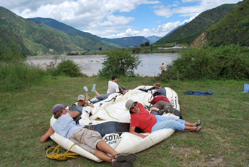 The First Bend of Yangtze River Rafting Tour in Lijiang
Overview of the Jinsha River
The Jinsha River, also known by names such as Shengshui, Yanshui, and Lushui, is distinguished by its yellowish sandy soil. It serves as a significant boundary river between the Sichuan and Tibet regions. In the 1970s, the source of the Jinsha River—and consequently the Yangtze River—was determined to be the Gyalmo Ngulchu Snow Mountain, a principal peak of the Tanggula Mountains located in Qinghai Province. The river’s main tributary, the Tuotuo River, originates from a mountain northeast of a 5,054-meter peak in the eastern section of the Tanggula Mountains, within Zaduo County, Yushu Prefecture.
Geographical Journey
From Source to Jinsha River
After the confluence of the Tuotuo River from Tanggula Mountain Town, Golmud City, Qinghai, and Tuotuo River from Tanggula Mountain, it forms the Tongtian River. The primary stream of the Yangtze River traverses regions including Zado County, Qumalai County, Zaduo County, and Yushu County. Below Zidomenda (Xiedu Village, Xiedu Township, Duoxian County, Yushu Prefecture), it is referred to as the Jinsha River.
![]()
Flow Through Provinces
The Jinsha River weaves its way through Sichuan, Tibet, and Yunnan provinces, meeting its largest tributary, the Yalong River, and is then named the Changjiang River at Yibin, Sichuan. From its source in Qinghai Province to Yibin City, the main stream stretches approximately 3,481 kilometers (or 3,364 kilometers, according to some sources), with a drainage area of about 502,000 square kilometers (or 473,200 square kilometers). This accounts for roughly 26% of the Yangtze River basin. The Jinsha River boasts an average annual flow rate of 4,750 cubic meters per second, primarily fed by precipitation, supplemented by groundwater and ice melt.
Topographical Features
With a dramatic elevation drop of 3,300 meters (some reports suggest 5,100 meters), the Jinsha River possesses immense hydroelectric potential, estimated at over 100 million kilowatts. This accounts for more than 40% of the Yangtze River’s hydroelectric resources. The river’s main stream is planned for multi-level cascade hydropower development. Due to the river’s steep gradients and rapid currents, the Jinsha River presents hazardous navigation conditions, with significant sediment erosion making it a major sediment source at Yichang station on the Yangtze River.
Historical and Cultural Significance
Evolution of the Name
Throughout its history, the Jinsha River, known as the upper reach of the Yangtze River, has been referred to by various names:
- Heishui: As mentioned in the Book of Yu Gong over 2,000 years ago during the Warring States period.
- Shengshui: As recorded in the Shan Hai Jing.
- Yanshui: During the Eastern Han Dynasty, upper parts of the river were referred to as Yanshui, with the Yalong River as the main stream.
- Lushui: Named during the Three Kingdoms period; it was famously crossed by Zhuge Liang.
By the Song Dynasty, significant deposits of gold sand found in the river led to it being renamed the Jinsha River. The poet Chen Zhisui’s poem “Jinsha River Chant” reflects on the arduous labor of extracting gold from the river’s sands. The Ming Dynasty geographer Xu Xiake later confirmed the Jinsha River as the true source of the Yangtze, correcting misconceptions that had persisted since the Book of Yu Gong.
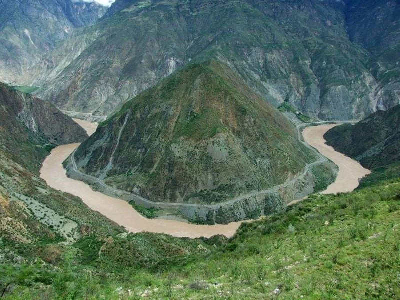
The First Bend of the Yangtze River
A notable feature along the Jinsha River is the “First Bend of the Yangtze River,” which occurs at Shigu in Lijiang. Here, the river makes a dramatic “U”-shaped turn, flowing southeast before bending northeast. The river’s confluence with its major tributaries and the formation of the bend make this section historically and culturally significant. It was at Shigu that the Red Army crossed the Jinsha River during their Long March in April 1936.
![]()
The Upper Section of the Jinsha River
Course and Features
The upper section of the Jinsha River flows from Tibet into the northeastern part of Deqin County, Yunnan Province. It crosses key areas such as Songmai River Mouth, Benzilan, and reaches Shigu Town in Yulong Naxi Autonomous County. Spanning about 965 kilometers, this section features a total elevation drop of 1,720 meters, with an average gradient of 1.78‰.
Notable Mountains and Valleys
Along this upper stretch, towering peaks and snow-covered mountains line the riverbanks:
- Left Bank: Que’er Mountain, Sharuli Mountain, and Zhongdian Snow Mountain.
- Right Bank: Dalama Mountain, Ningjing Mountain, Mangkang Mountain, and peaks of the Yunling Range.
The river generally follows fault zones, creating narrow valleys flanked by high mountains, with widths ranging from 50 to 200 meters. To the west of Ningjing Mountain lies the Lancang River, and beyond the imposing Taniangtaweng Mountain and Nu Mountain is the treacherous Nu River. This region’s distinctive geography features steep cliffs and slopes, with a drainage pattern that restricts the development of tributaries.
![]()
The Middle Section of the Jinsha River
Stretch and Topography
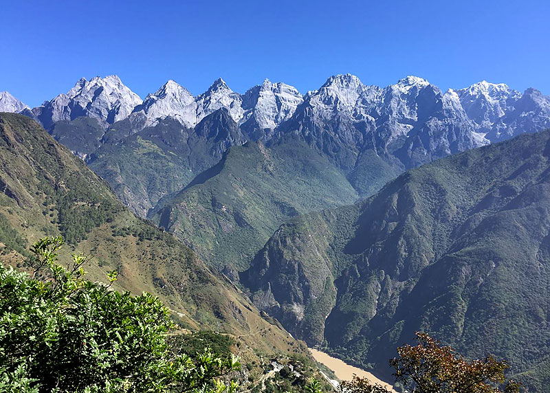
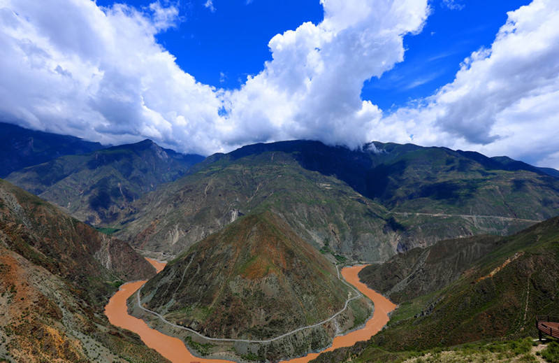
The middle section of the Jinsha River extends approximately 1,220 kilometers from Shigu Town, Yulong Naxi Autonomous County, Yunnan Province, to Xinshi Town, Sichuan Province. This section includes the iconic Tiger Leaping Gorge, renowned for its breathtaking scenery and challenging rapids. The river here flows through deep gorges with dramatic drops, forming a concentrated rapids zone.
Tiger Leaping Gorge
Tiger Leaping Gorge is a highlight of this section, located near Qiaotou Town in Zhongdian County. The upper and lower mouths of the gorge are just 16 kilometers apart, yet the river drops a staggering 220 meters, with an average gradient of 13.8‰. The gorge narrows to only 30 meters in some places, with rapid currents reaching speeds of 10 meters per second. On either side of the gorge stand the Jade Dragon Snow Mountain (5,596 meters) and Haba Snow Mountain (5,396 meters), creating a stunning natural spectacle.
Downstream of Tiger Leaping Gorge
After exiting Tiger Leaping Gorge, the Jinsha River flows northeast to Sanjiangkou, where it makes a sharp turn southward. As the river continues its journey, it passes by significant landmarks, including the planned site for the Zili Water Conservancy Hub Dam and the historic crossing at Jiaopingdu, an important site during the Red Army’s Long March.
Jinsha-Yangtze River in Yunnan Province
The Jinsha River flows for 1,560 kilometers within Yunnan Province, with a drainage area of 109,000 square kilometers [34]. The river’s southern banks within Yunnan encompass areas in the northeastern part of the province, including Diqing Tibetan Autonomous Prefecture, Lijiang City, Dali Bai Autonomous Prefecture, Chuxiong Yi Autonomous Prefecture, Kunming City, Qujing City, and Zhaotong City.
Diqing Tibetan Autonomous Prefecture
Established in September 1957, Diqing Tibetan Autonomous Prefecture, whose name means “A Land of Auspiciousness” in Tibetan, is the only Tibetan autonomous prefecture in Yunnan Province. It is located in the northwest of Yunnan Province, situated at the intersection of Yunnan, Sichuan, and Tibet on the southern extension of the Qinghai-Tibet Plateau. It is the heart of the world-famous Shangri-La and the core area of the “Three Parallel Rivers” World Natural Heritage site. The Lancang and Jinsha Rivers traverse the entire region from north to south, creating a unique landscape known as “snow-capped mountains as city walls, and rivers as moats,” making it a dazzling pearl on the northwest Yunnan Plateau.
Diqing is home to 26 ethnic groups, with the most populous being Tibetans, Lisu, Han, Naxi, Bai, Hui, Yi, Miao, and Pumi, among others. Ethnic groups such as Tibetans, Lisu, and Naxi have created vibrant and diverse cultural traditions. Shangri-La is the most famous tourist destination. Historically, Diqing was a critical passage on the ancient “Tea Horse Road” of southwest China and a major distribution center and commercial transit point for materials in the eastern Tibetan region, serving as a key access route to and from Tibet .
Lijiang City
Lijiang City is located in the northwest of Yunnan Province, at the juncture of the Yunnan-Guizhou Plateau and the Qinghai-Tibet Plateau. It boasts a long history, serving as the political, economic, and cultural center of northwestern Yunnan. During the Han and Tang dynasties, it was an important distribution center on the Southern Silk Road and the Tea Horse Road, which connected Tibet and India. In 1980, Lijiang District Administrative Office was established, and on December 26, 2002, with the approval of the State Council, Lijiang District was abolished, and Lijiang City was established.
Lijiang City’s most advantageous and developmentally promising resources are primarily its tourism, biological resources, and hydropower. Its tourism resources are represented by “two mountains (Jade Dragon Snow Mountain and Laojun Mountain), one city (Lijiang Old Town), one lake (Lugu Lake), one river (Jinsha River), one culture (Naxi Dongba culture), and one style (Mosuo style),” which form the economic backbone of the city .
Dali Bai Autonomous Prefecture
Dali Bai Autonomous Prefecture has a long history, with the “Nanzhao Kingdom” and “Dali Kingdom” establishing regional regimes during the Tang and Song dynasties. It is rich in tourism resources, with over 130 scenic spots and areas, including Jizu Mountain, a Buddhist holy site; Weibao Mountain, a Taoist sacred mountain; Shibao Mountain, a treasure trove of grotto art; and Erhai Lake, known as the “Pearl of the Plateau.” The Cangshan Mountain and Erhai Lake area is a national scenic spot, while “Cangshan Nature and Nanzhao Cultural Relics” are recognized as a national natural and cultural dual heritage. The capital of the autonomous prefecture, Dali, is among the first 24 historical and cultural cities designated by the state.
Dali has abundant mineral resources, with Jinyin Mountain platinum and palladium mine ranking as the second-largest in China, and Dali marble being the most famous, with proven reserves reaching 160 million cubic meters. Dali also possesses rich energy resources, with potential hydropower generating capacity up to 10 million kilowatts. It is home to the highest-altitude wind power plant in China, which has the largest installed capacity in southwest China. Its biodiversity makes Dali renowned as a major producer of walnuts, plums, and dairy cows .
Chuxiong Yi Autonomous Prefecture
Chuxiong Yi Autonomous Prefecture was established on April 15, 1958. Known as the “Hometown of Dinosaurs” and the “Hometown of Lufengosaurus,” it boasts tourism resources such as the Yuanmou Man fossil site, Yuanmou Earth Forest, and Lufeng Dinosaur Valley. The prefecture is famous for its dinosaur heritage, ancient town culture, Yi ethnic customs, and its pleasant climate with warm winters and cool summers. Key scenic spots include Shizishan Mountain in Wuding, Yuanmou Earth Forest, Yiren Ancient Town, Lufeng World Dinosaur Valley, Chuxiong Museum, Heijing Ancient Town, Mihilu Cultural Valley in Nanhua, Zixishan Mountain in Chuxiong, Shiyang Ancient Town in Dayao, Fangshan Mountain in Yongren, Chinese Yi Ethnic Ten Month Solar Calendar Cultural Park, Huafoshan Mountain in Mouding, Santan in Dayao, Guanglu Ancient Town in Yao’an, and Luowu Yi Village in Wuding. The prefecture has developed various industries, including tobacco, pharmaceuticals, metallurgy, food, building materials, coal, power, machinery, textiles, chemicals, and tourism services. The six key industries are tobacco, metallurgy and chemicals, green food, cultural tourism, biopharmaceuticals, and new energy and materials .
Kunming City
The name “Kunming” originates from the ancient “Southwest Yi” tribal group “Kunming.” Since the establishment of Yunnan Province during the Yuan Dynasty, this name has been used for the city. Kunming is the political, economic, cultural, and transportation center of Yunnan Province, and is one of China’s top ten key tourist cities and an emerging international tourist city. Located in a low-latitude plateau, Kunming is surrounded by mountains on three sides and borders Dianchi Lake to the south. With a mild climate year-round, often described as “like February or March,” Kunming is known as the “Spring City.” The city is famous for its picturesque scenery, fresh air, and abundant tourism resources. In Kunming, visitors can enjoy the vast expanse of Dianchi Lake, the towering rock formations of the Stone Forest, as well as numerous nationally and provincially protected scenic spots and historic sites. Kunming is also a city with a variety of ethnic customs, where visitors can experience the diverse cultural traditions of different ethnic groups. It is referred to as the “Kingdom of Flora and Fauna.” On May 10, 1999, Kunming hosted the “99 World Horticultural Exposition” .
Qujing City
Qujing has a long history, with the establishment of Qu and Jing prefectures during the Tang Dynasty, which were named “Qujing” due to their geographic proximity. Qujing is a melting pot of Central Plains culture and Yunnan ethnic minority cultures, and over the past two millennia, it has developed a distinct “Pearl River Source” culture characterized by two ancient ethnic groups, copper merchants, and diverse ethnic customs. It is home to significant cultural relics, including the “Treasure of Southern Inscriptions,” the Stele of the Cuan Baozi, the Stele of Cuan Longyan, and the ancient copper merchant trading routes. The Red Army passed through Qujing twice during the Long March, with Mao Zedong famously writing “The imposing Wumeng will make easy steps for us.” Qujing is rich in natural resources, including coal, phosphate, lead, and zinc, as well as abundant water resources. It features natural attractions such as the Pearl River Source, the Duoyi River, the colorful sand forests, and karst landscapes, and is home to numerous nationally protected rare wildlife species. Fossils of ancient fish from the Devonian period, around 420 million years ago, and Triassic fossils in Luoping, give Qujing the title of the ancient “hometown of fish.” The city has four national AAAA-level tourist sites and nine provincial-level scenic areas. Historically known as the “gateway to Yunnan,” Qujing is intersected by three railways and four national highways, making it a crucial gateway for many Chinese provinces to enter and exit Yunnan, as well as a key land transportation hub for Yunnan’s access to inland regions, southeast coastal areas, and the Southwest, extending towards Southeast Asia and the Indian subcontinent. Qujing ranks first in agricultural value-added output in the province, with its GDP, fiscal revenue, and industrial value-added output ranking second in Yunnan .
Zhaotong City
Historically known as “Zhuti” and “Wumeng,” Zhaotong serves as an important passage for Central Plains culture into Yunnan and is a crucial point on the ancient “Southern Silk Road.” It is one of the three main cradles of early Yunnan culture. In February 1935, the Red Army of the Chinese Workers’ and Peasants’ Revolutionary Army passed through here during the Long March, with the Central Committee of the Communist Party of China holding the historically significant “Zaxi Conference” in Weixin County. Known as the “throat of western Sichuan and key to southern Yunnan” and the “northern gate of Yunnan,” Zhaotong is connected by the Neikun Railway, Kunshui Expressway, Zhaotong Airport, and Shuifu Port, the first port on the Yangtze River, forming a transportation hub that links Yunnan, Sichuan, and Guizhou provinces. The city is renowned for its diverse tourism resources, such as the ancient Wumeng Mountains, the beautiful “Pearl of the Yunnan-Guizhou Plateau” Qiaojia Tianchi, the “Pearl of the Western Sichuan Plateau” Jinsha River Basin, the Dashanbao Black-necked Crane Nature Reserve, as well as historical and cultural sites like the “Shuanghe Confucian Temple” and “Lushi Temple” .


