 7 Days GolfingTour
 8 Days Group Tour
 8 Days Yunnan Tour
 7 Days Shangri La Hiking
 11 Days Yunnan Tour
 6 Days Yuanyang Terraces
 11 Days Yunnan Tour
 8 Days South Yunnan
 7 Days Tea Tour
 8 Days Muslim Tour
 12 Days Self-Driving
 4 Days Haba Climbing
 Tiger Leaping Gorge
 Stone Forest
 Yunnan-Tibet
 Hani Rice Terraces
 Kunming
 Lijiang
 Shangri-la
 Dali
Dali
 XishuangBanna
 Honghe
 Kunming
 Lijiang
 Shangri-la
 Yuanyang Rice Terraces
 Nujiang
 XishuangBanna
 Spring City Golf
 Snow Mountain Golf
 Stone Mountain Golf
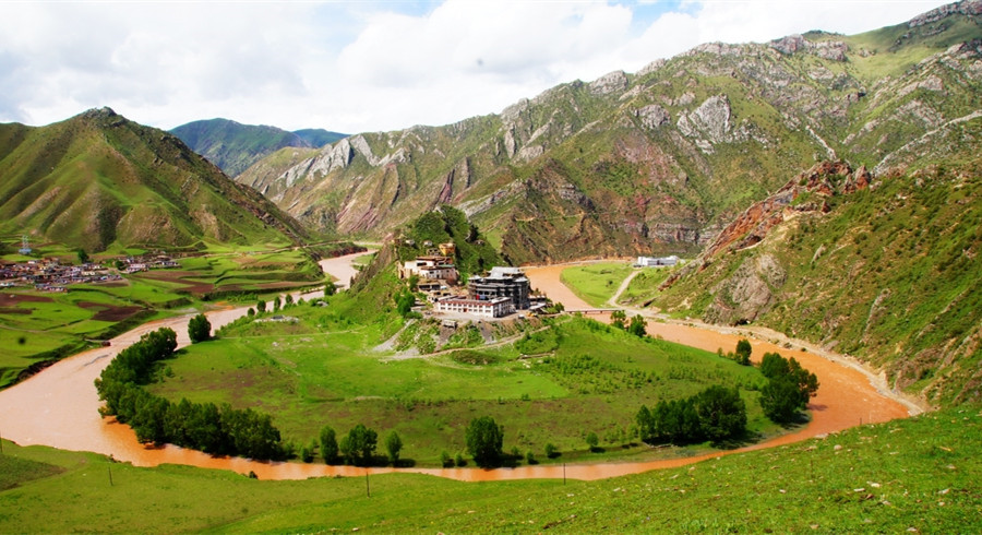
The Great Bend of Lancang-Mekong River in Deqin County, Diqing

Attraction Overview
The Great Bend of Lancang-Mekong River is not only known for its deep and long valley, but also for its rapid river flow. The water in summer is muddy and surging, and in winter is clear and rapid, with the narrow river waves hitting the shore and the water sound of thunder, very spectacular.
Attraction Type: River
Chinese Name: 澜沧江大拐湾(Pinyin: Lancangjiang Daguaiwan)
Open Hours: All Day
Altitude: 6,740 meters
Location: about 10 kilometers north-east of Deqin County, Diqing Tibetan Autonomous Prefecture of Yunnan Province
The Great Bend of the Lancang-Mekong River (澜沧江大拐弯) is one of the most striking natural wonders in Deqin County (德钦县), Diqing Tibetan Autonomous Prefecture (迪庆藏族自治州), located in the northwestern part of Yunnan Province (云南省), China. The river here makes an impressive U-turn, flowing through deep valleys and towering mountains, creating a visually stunning and breathtaking landscape. This unique geographical feature is not only a natural marvel but also an important cultural and ecological site, rich in biodiversity and steeped in local traditions.
Location
The Great Bend is located in the Lancang River (澜沧江) valley, specifically in Deqin County, part of Diqing Tibetan Autonomous Prefecture. This area is about 300 kilometers north of Lijiang (丽江) and is situated in the high-altitude region of the Himalayan Mountains (喜马拉雅山脉). It lies at the meeting point of several cultures, primarily the Tibetan (藏族) and Naxi (纳西族) ethnic groups, offering both cultural richness and natural beauty.
Scenic Features
The Great Bend of the Lancang-Mekong River is famous for its spectacular views. The river bends sharply around a massive mountain peak, creating an almost 180-degree curve. The area offers the following highlights:
-
Dramatic Views: The bend offers panoramic views of the river, with steep cliffs on both sides. The lush vegetation and clear waters of the river reflect the surrounding snow-capped peaks, making it a photographer’s paradise.
-
Snow-Capped Peaks: The snow-covered mountains surrounding the Great Bend, including the Meili Snow Mountain (梅里雪山), provide a stunning backdrop, especially during the winter months when the area is blanketed in snow.
-
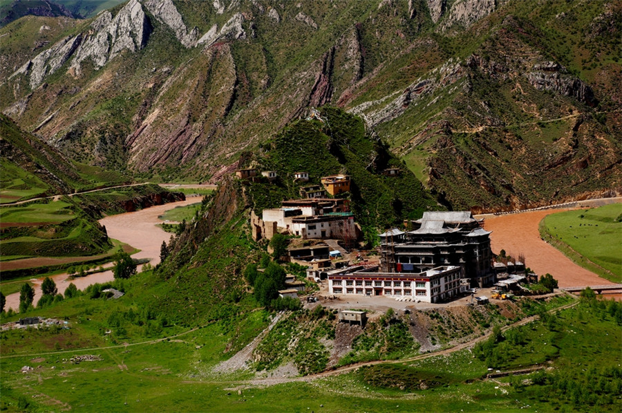
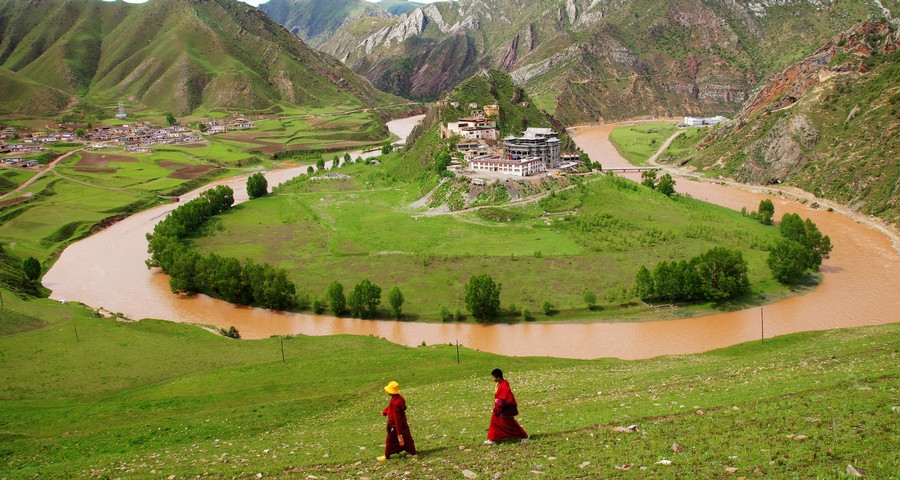
Cultural Significance: This region is home to the Tibetan people, who have lived in harmony with the land for centuries. Local Tibetan monasteries and villages dot the landscape, adding a spiritual dimension to the natural beauty.
-
Biodiversity: The area is rich in flora and fauna, with rare species of plants and animals inhabiting the region. The river basin is a vital water source for the local communities, and the surrounding forests are full of diverse plant species.
-
Cultural Heritage: The bend is a key site for the Tibetan culture and Buddhist traditions. Local Tibetan villages and monasteries are steeped in history and provide a unique opportunity for cultural exploration.
About the Great Bend of Lancang River in Deqin
🌟 Scenic Highlights
Geological Marvel
The Lancang River (澜沧江) carves through the Hengduan Mountains, forming a nearly 2-kilometer-wide Ω-shaped bend. With cliff faces rising over 1,000 meters, the landscape delivers a powerful visual impact—“a jade ribbon embraced by emerald mountains.”
Ecological Sanctuary
At the curve’s inner bank, an alluvial oasis supports several multi-ethnic villages, including the Naxi and Lisu peoples. The terraced fields bloom with rapeseed flowers in spring and glow with red cypress during autumn, painting the river valley in rich seasonal hues.
Snow Mountain Backdrop
On clear days, the Meili Snow Mountains (梅里雪山) can be seen reflected in the river’s surface. When morning mist lingers, the entire canyon transforms into a mystical realm.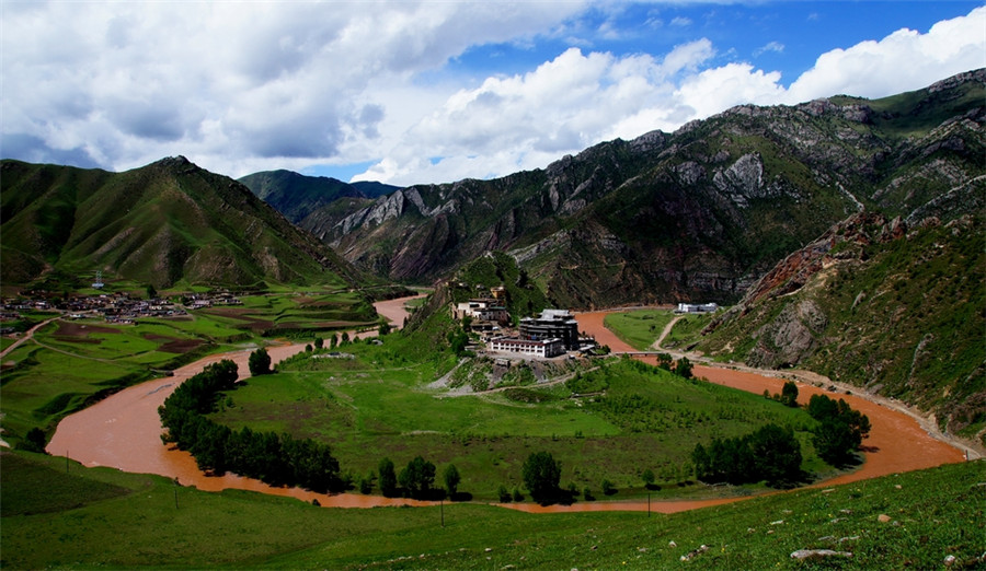
📍 Practical Information
Location
The bend is located in Foshan Township, Deqin County, Diqing Prefecture, Yunnan Province. It lies directly along the G214 Yunnan-Tibet Highway.
Navigation Tip
Search for “Lancang River Grand Bend Viewpoint (澜沧江大拐弯观景台)”.
⚠️ Don’t confuse this with the Jinsha River Grand Bend (金沙江大拐弯) in Benzilan Town, which is about 50 km away in straight-line distance.
Transportation Options
-
Self-Drive: From Shangri-La City, drive north along G214 for approximately 3 hours, crossing Honglashan Pass (红拉山口) where Meili Snow Mountain comes into view.
-
Private Car Hire: From Deqin County, it’s about 1.5 hours to the viewpoint.
🚨 In the rainy season, falling rocks are frequent—drive carefully.
⏰ Best Time to Visit
Best Season
-
Dry Season (November to April): River water appears clear and green
-
Rainy Season (June to August): Water turns muddy but becomes visually powerful and dramatic
Best Time of Day
-
2 hours after sunrise: For misty, cinematic light and shadow
-
1 hour before sunset: Snow peaks glow golden under the setting sun

⚠️ Visitor Notes
Safety Tips
The viewpoint is set on a cliff edge with no guardrails. Stay away from the edge and bring a windproof jacket, as canyon gusts can reach level 7 winds.
Cultural Etiquette
The lush green villages below are home to local indigenous communities. Do not enter homes or farmland without prior permission.
Itinerary Extensions
You can combine this destination with visits to:
-
Meili Snow Mountain (梅里雪山)
-
Jinsha River Bend (金沙江大拐弯)
❄️ Avoid winter snow days due to ice-prone roads.
🏞️ A Natural Turning Point
The Lancang River, internationally known as the Mekong, makes a spectacular turn here as it leaves the Tibetan Plateau and begins its journey toward Southeast Asia.
This epic curve, together with the 72 Bends of the Nujiang River (怒江七十二拐) and the Stone Tower Bay of the Yellow River (黄河石楼湾), is hailed as one of China’s three greatest canyon wonders.


