-
- Home
- Yunnan Tours
Most Popular Yunnan ToursEssential Yunnan TripsFind Yunnan Tours by MonthFind Yunnan Tours by Duration
- Group Tours
Popular Yunnan Group ToursAll Yunnan Group Tours
- 1 Day Kunming Stone Forest Group Tour
- 1 Day Jade Dragon Snow Mountain Group Tour
- 2 Days Tiger Leaping Gorge Hiking Group Tour
- 4 Days Haba Snow Mountain Climbing Group Tour
- 6 Days Yuanyang Hani Rice Terraces Group Tour
- 8 Days Kunming-Dali-Lijiang-Shangri-la Group Tour
- 8 Days Yunnan Chinese-Speaking Group Tour
- 15 Days Yunnan-Tibet Small Group Tour
- Themes Tours
- City Tours
- Travel Guide
- Attractions
- Customize
 7 Days GolfingTour
 8 Days Group Tour
 8 Days Yunnan Tour
 7 Days Shangri La Hiking
 11 Days Yunnan Tour
 6 Days Yuanyang Terraces
 11 Days Yunnan Tour
 8 Days South Yunnan
 7 Days Tea Tour
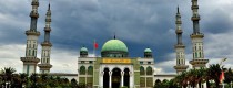
 8 Days Muslim Tour
 12 Days Self-Driving
 4 Days Haba Climbing
 Tiger Leaping Gorge
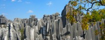
 Stone Forest
 Yunnan-Tibet
 Hani Rice Terraces
 Kunming
 Lijiang
 Shangri-la
 Dali
Dali
 XishuangBanna
 Honghe
 Kunming
 Lijiang
 Shangri-la
 Yuanyang Rice Terraces
 Nujiang
 XishuangBanna
 Spring City Golf
 Snow Mountain Golf
 Stone Mountain Golf
You Might Like
- 1 Day South XishuangBanna Tour to Damenglong White Pagoda and Dai Ethnic Villages

- 1 Day Kunming Stone Forest and Nuohei Ethnic Village Tour
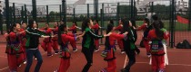
- 5 Days Kunming Ethnic Culture Education Tour
- 4 Days Dali-Lijiang Group Tour By High Speed Train (Chinese-Speaking)
- 6 Days Kunming Shadian Muslim Tour with Yuanyang Rice Terraces and Jianshui Old Town
- 6 Days Yunnan Coffee, Tea and Minority Culture Tour to Puer and XishuangBanna
- 2 Days Haba Snow Mountain Climbing Tour from Haba Village
- 8 Days Best Yunnan Speed Train Tour-Kunming Dali Lijiang Shangri-La


Air Corridor of Wangtianshu Scenic Area in Mengla County, XishuangBanna
📍 Location Address: No. 9, Lunhuo Alley, Dukezong Ancient Town, Jiantang Town, Shangri-La City, Diqing Prefecture, Yunnan, China Altitude: Approx. 3,300 meters Setting: On top of Guishan (a small...

Mangling One Tree Forest in Ruili City, Dehong
Why is Mangling One Tree Forest So Special Mangling One Tree Forest grows on the side of No. 320 National Highway. It is lush and tall and towering. It seems...

Dahuicun Mosque in Tonghai County, Yuxi
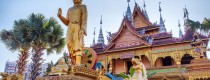
Dahuicun Mosque (通海县大回村清真寺) is located 21 kilometers northwest of the county seat of Tonghai County (通海县), Yunnan Province (云南省). Originally built during the Ming Dynasty, the mosque now occupies...

Nalou Zhangguansi Shu in Jianshui County, Honghe
🏯 Naluo Yi Chieftain’s Official Residence (纳楼长官司署) “The Miniature Yi Palace Hidden in the Mountains” 📍Location & Transportation Address: Huixin Village, Potou Township, Jianshui County, Honghe Prefecture, Yunnan Province....

The Lower Section of Tiger Leaping Gorge
The Lower Section of Tiger Leaping Gorge Hiking across the “Huashiban landslide”(滑石板) which is a landslide in the Middle Section of Tiger Leaping Gorge, you will find the Lower...

Guanyin Waterfall of Tiger Leaping Gorge
Guanyin(Goddess of Mercy) Waterfall of Tiger Leaping Gorge The most wonderful waterfall and cliffs during the hiking tour of Tiger Leaping Gorge Guanyin Waterfall is the largest waterfall...

Huanglong Temple in Jianshui County, Honghe
Chinese Name:建水黄龙寺 English Name: Huanglong Temple in Jianshui County, Honghe Jianshui Huanglong Temple Located at the foot of Shaohe Mountain, 12 kilometers west of Jianshui City in Honghe Prefecture,...

Boduoluo Village in Yulong County, Lijiang
Boduoluo Village or Yangyuchang Village in Yulong County Boluoduo means the most beautiful village in the world. It is the origin of Yi ethnic minority of Lashihai, also the...

Mengba Naxi Rare Park in Mangshi City, Dehong
Why is Mengba Naxi Rare Park So Special Mengba Naxi Rare Park holds four of best records among all parks of China: The biggest number as well as the...

Dayingjiang River in Dehong
Why is Dayingjiang River So Special Beautiful Dayingjiang River runs through Yingjiang County in west Yunnan border area. The river mouth is open and its surface is as flat...

Xiaomiaojie Mosque in Yuxi City
Xiaomiaojie Mosque (小庙亍清真寺), formerly known as Zhoucheng Mosque (州城清真寺), is located at No. 92 Fenghuang Road (凤凰路92号), Yuxi City (玉溪市), Yunnan Province (云南省). The current imam is Ma Jiecong...

Yingjiang National Wetland Park, Dehong
Why is Yingjiang National Wetland Park So Special Yingjiang National Wetland Park still maintains the basic appearance of the river and wetland without much artificial modification, and is full...
Latest Articles

Kunming Events Calendar
2025-08-05

Lijiang Festivals and Events in January
2025-08-04
Dali Festivals and Events in January
2025-08-04Contact Info

