-
- Home
- Yunnan Tours
Most Popular Yunnan ToursEssential Yunnan TripsFind Yunnan Tours by MonthFind Yunnan Tours by Duration
- Group Tours
Popular Yunnan Group ToursAll Yunnan Group Tours
- 1 Day Kunming Stone Forest Group Tour
- 1 Day Jade Dragon Snow Mountain Group Tour
- 2 Days Tiger Leaping Gorge Hiking Group Tour
- 4 Days Haba Snow Mountain Climbing Group Tour
- 6 Days Yuanyang Hani Rice Terraces Group Tour
- 8 Days Kunming-Dali-Lijiang-Shangri-la Group Tour
- 8 Days Yunnan Chinese-Speaking Group Tour
- 15 Days Yunnan-Tibet Small Group Tour
- Themes Tours
- City Tours
- Travel Guide
- Attractions
- Customize
 7 Days GolfingTour
 8 Days Group Tour
 8 Days Yunnan Tour
 7 Days Shangri La Hiking
 11 Days Yunnan Tour
 6 Days Yuanyang Terraces
 11 Days Yunnan Tour
 8 Days South Yunnan
 7 Days Tea Tour
 8 Days Muslim Tour
 12 Days Self-Driving
 4 Days Haba Climbing
 Tiger Leaping Gorge
 Stone Forest
 Yunnan-Tibet
 Hani Rice Terraces
 Kunming
 Lijiang
 Shangri-la
 Dali
Dali
 XishuangBanna
 Honghe
 Kunming
 Lijiang
 Shangri-la
 Yuanyang Rice Terraces
 Nujiang
 XishuangBanna
 Spring City Golf
 Snow Mountain Golf
 Stone Mountain Golf
You Might Like
- 3 Days Pingbian Yunnan-Vietnam Railway and Daweishan Mountain Tour from Kunming

- 24 Days Laos-China-Kyrgyzstan Self-Driving Tour from Yunnan Mohan to Xinjiang Kashgar
- 17 Days Grand Shangrila Overland Tour from Chengdu (Sichuan) to Kunming (Yunnan)
- 5 Days Kunming and Luoping Rapeseed Flowers Photography Tour
- 14 Days Yunnan Three Parallel Rivers Circle Tour from Kunming
- 1 Days Yuanyang Hani Rice Terraces Hiking Tour
- 2 Days Yingjiang County Birding Tour
- 7 Days Shangri-La Hiking Tour: Abuji Cuo Lake, Thousand Lakes Mountain and Meili Snow Mountain


Wenbi Pagoda in Jianshui County, Honghe
Wenbi Pagoda (文笔塔) A Monument to Knowledge and Harmony Towering Above Jianshui 📍 Basic Information & Location Location: Wenbi Pagoda is perched atop Mount Baifo (拜佛山) in Baishuihe Village...

Jianshui Examination Hall, Honghe
Chinese Name:建水学政考棚 English Name: Jianshui Examination Hall, Honghe The Jianshui Xuezheng Examination Hall, also known as the “Provincial Education Commissioner Examination Hall,” is a well-preserved ancient examination venue lo...

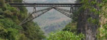
Wanding Bridge in Ruili City, Dehong
Why is Wanding Bridge So Special Wanding Bridge is located on the urban side of the downtown of the Wanding Town; it is the boundary bridge between China and...

Jianshui Narrow-gauge Railway Sightseeing Tour
🚂 Jianshui Mini Train (建水小火车) A Moving Museum of Railway History Nicknamed the “living fossil of a century-old railway,” the Jianshui Mini Train runs on meter-gauge tracks (1-meter width),...

Mohei Ancient Town in Ninger County, Pu’er
🏞️ Mohei Ancient Town (磨黑古镇) A Cultural Gem in Southern Yunnan Once a salt capital, revolutionary stronghold, and key node on the Tea Horse Road, Mohei (磨黑) is a...
Dali City (Xiaguan Town)-Eryuan County Transportation
Dali City and Eryuan County are both under the administration of Dali Bai Autonomous Prefecture. Eryuan County(洱源县) is one of the counties under the jurisdiction of Dali Prefecture of Yunnan...

Yunnan Red Wine Villa in Mile County, Honghe
Yunnan Red Wine Chateau (云南红酒庄) 📍 Basic Information Location: Dongfeng Farm, Li’a Road, Xinshao Town, Mile City, Honghe Prefecture (14 km from Mile city center, 150 km from Kunming)...

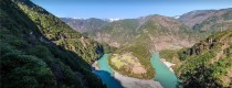
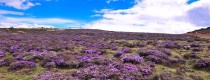
Haba Village in Shangrila, Diqing
Brief Introduction The main reason people visit Haba village in the mountains of northern Yunnan is to trek up the Haba Snow Mountain. The area has become a major...

The Sky Ladder of The Middle Section of Tiger Leaping Gorge
🧗♂️ The Ladder (天梯): A Vertical Adventure in Middle Tiger Leaping Gorge Core Features of The Ladder Steep, Vertical StructureThe Ladder consists of four nearly vertical sections of iron...

The Ancient Wells in Jianshui County, Honghe
🏺 1. The Unique Value of the Ancient Wells A City of a Hundred Wells “City of a Hundred Wells”: With 128 ancient wells still intact, Jianshui boasts the...

Changsheng Village in Tiger Leaping Gorge
Changsheng Village Changsheng Village is located in the Northeast of Tiger Leaping Gorge Town, Shangri-La, consisted of Nuoyu Village, Bendiwan Village and Yachaguo Village, etc. Changsheng Village is the...

Yixiantian in the Middle Section of Tiger Leaping Gorge
🌄 Scenic Highlights & Location A Natural Wonder: Yixiantian Gorge Carved by the mighty Jinsha River, Yixiantian (literally “A Ray of Sky”) is a breathtaking gorge with sheer cliffs...
Latest Articles

Kunming Events Calendar
2025-08-05

Lijiang Festivals and Events in January
2025-08-04
Dali Festivals and Events in January
2025-08-04Contact Info

