 7 Days GolfingTour
 8 Days Group Tour
 8 Days Yunnan Tour
 7 Days Shangri La Hiking
 11 Days Yunnan Tour
 6 Days Yuanyang Terraces
 11 Days Yunnan Tour
 8 Days South Yunnan
 7 Days Tea Tour
 8 Days Muslim Tour
 12 Days Self-Driving
 4 Days Haba Climbing
 Tiger Leaping Gorge
 Stone Forest
 Yunnan-Tibet
 Hani Rice Terraces
 Kunming
 Lijiang
 Shangri-la
 Dali
Dali
 XishuangBanna
 Honghe
 Kunming
 Lijiang
 Shangri-la
 Yuanyang Rice Terraces
 Nujiang
 XishuangBanna
 Spring City Golf
 Snow Mountain Golf
 Stone Mountain Golf


 What Our Customers Say?
 alt="Market Days in Menglian and Townships, Puer"
/>
alt="Market Days in Menglian and Townships, Puer"
/>
Yunnan Cycling Tour along The Burma Road and Stilwell Road from Dali to Yangbi
Burma Road(滇缅公路) is divided into two parts by Dali. The sections from Kuming to the east of Dali is about 400 kilometers. There is no natural barriers though the hills stretch over 400 kilometers from Kuming to Dali. And there are some state highways between two places. Therefore, it is not terribly hard to completed the construction of the east of Burma Road. Although it was cost 9 years to complete this construction project,the mainly causes were financial and mobilization capacity issues. What incredibly difficult to construct is the rest of road which from Dali to Wanding(畹町). All in all, this magnificent construction itself has been counted as a legend.
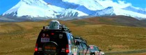
From now on, we will set off from Dali and take a trip to the most legendary and monumental Road.
We couldn’t get to Yangbi county outside the 34 kilometers on time due to the heavy rain last night. In order to catch up with the schedule, Mr Xu persist that we had to take a bus to Yangbi. It was a pity that we couldn’t visit Tianshengqiao Bridge(天生桥) because of the changing plan.
Tianshengqiao Bridge(天生桥) is located in western suburb of Xiangguan and near the downtown. When I was a child, I often killed a few hours by wandering round Xiaguan and slipped into Tianshengqiao Bridge which is regarded as a little interest. Tianshengqiao Bridge is located in Cangshan Mountains (苍山),south it near Xieyang Mountain(斜阳峰), north it near Ailao mountain(哀牢山). Just between the two peaks formed a natural bridge, and under the “stone bridge”,is the water outlet of Erhai——Xier River(西洱河).
Historically, the dominant center of Dali area is always located between Erhai and Cangshan Mountains. A north-south narrow plain that is the ancient city of Dali. The area uses the Cangshan Mountains and Erhai as an east-west barrier. It has also established two passes between them which are called Longshouguan (龙首关/上关Shangguan) in the north and Longweiguan (龙尾关/下关Xiaguan) in the south that is formed a complete defense system. Xiaguan is located in the north bank of Xier Rivers in the west side of Xiaguan City. The city wall is still in existence.
And today’s Xiaguan city is the former Longweiguan’s wilderness. Tang dynasty Tianbao years(唐天宝年间), the emperor’s army conquered nanzhao twice in this area. Unluckily, the whole army was completely wiped out and lost nearly 200000 soldiers who were conscript from Guanzhong and Henan.
After these two battles, popular grievances run high and no more soldiers to fight. The following year, the cataclysmic An Shi Rebellion (安史之乱) was broken out, so the rebels were able to drive down Changan(长安). Tianbao Rebellion(天宝战争) is a rare event in the history in the Yunnan that changed the history of China. For details,Please refer to the text I sent on September5,2008.
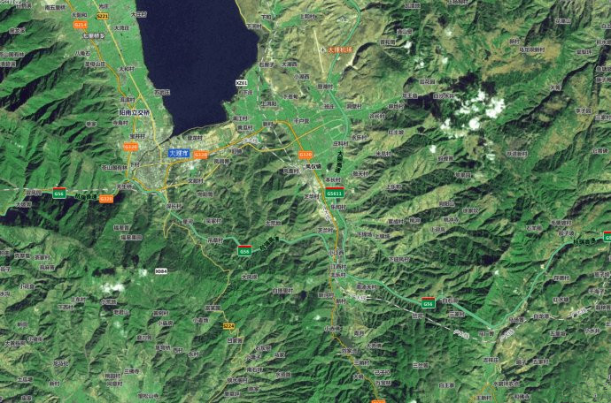
The following picture shows Xiaguan (下关城区), Xier River(西洱河) and Tianshengqiao Bridge(天生桥) areas.
Let’s turned the topic back to Tianshengqiao Bridge(天生桥). In terms of terrain, the Tianshengqiao Bridge is actually dangerous, but from here on, across Cangshan Moutains(苍山), along the west Erhe River(西洱河) to the west is the only choice for the road construction. This was the case with Burma Road in that way ,and so is today’s highway. It is not easy to carve out a way through the Hengduan Mountains. By the end of 1937 years, the west part of the Burma Road was officially started. In order to build this section of road which is less than ten kilometers. More than a hundred people were injured and killed in blasting rocks.
Compared with the eastern section, the most important feature of the western Burma Road is that it will cross several rivers which run from south to north. Rocks rise steeply on both sides of the rivers. Since ancient times, only the horse caravan has been crossed by flying cables. To build a bridge that can pass through cars, there is a need for a considerable area of flat land on both sides of the river, however, such locations are rare. In order to repair the road to the location of the bridge, it was necessary to dig out of a way of the mountains along the river bank. The construction method was usually to hang people from the top of the mountain to the construction site to drill holes,and then blasting with homemade explosives.
When Burma Road was nearly completed in 1938 ,the famous journalist Xiao Gan(萧乾) interviewed along the way and wrote the article “Recalling the construction of Yunnan-Burma Road”《血肉筑成的滇缅路》. If you have spare time you can appreciate it,and feel the tenacity and suffering of this nation.
The article describes the drilling holes as follows. “If working conditions of drilling holes on the Burma Road are seen by people with fragile hearts, they will immediate faint. It is extremely difficult to chisel a nine-meter-wide tunnel through a cliff. The worker was tied to the waist with a belt. One end tied to the trunk of ” the cliff foot. Then people hang down like bamboo basket on a bridge. When they reached line,they began to hammer holes. Looking up, there are range upon range of mountains, bushes and grass. Looking down, billows come rolling for one thousand. So people hang like roast duck on the cliffs .After chiseling the holes, putting explosives in. This is not the latest type of explosive,and therefore there is no guarantee of safety. In order to prevent it from exploding suddenly, another layer of sand must be covered before light it.Man must climb to the cliff as quick as an ape. A step too slow, and the man is gone with rock.
Judging from the current statistics, a large number of casualties will inevitably injured or dead in such a large scale blasting. Tianshengqiao Bridge (天生桥) is the first place, to say nothing of Dalishu(大栗树),Gongguo bridge(功果桥),Huitong Bridge(惠通桥) and so on. In next few days, these sections will be visited one by one.
At that moment, the car has passed the Natural Bridge(天生桥).The left side of high way is the old Burma Road,and there is nothing special about it.
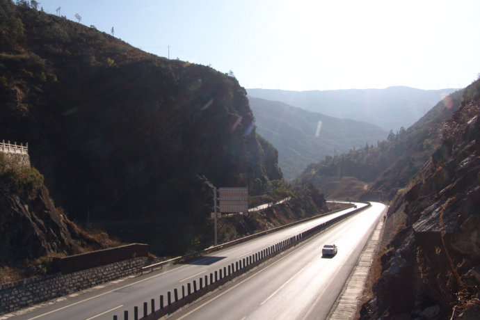
Through valleys, out of Pingpo town(平坡镇), been away from freeway. From now on, 320 state road will separated from the the old Burma Road. Natural expressway and highway will be all the way to the west. But constrained by construction capacity, the Burma Road was unable to across the Yangbi River (漾濞江)directly. And it was impossible to cross the cloud -entering mountains in the west bank. So it had to go along with Yangbi River until to Yangbi county(漾濞县). The small section of the road is today’s S236 Provincial Highway.In figure below, you can see the old Burma Road that is south of the G320.
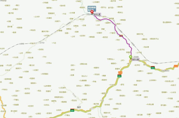
We moved about 10 kilometers along the S236 Road and left the provincial road to a small road on the riverside. In front of us was an unremarkable simple highway bridge. A milestone at the end of the bridge was a real surprise.
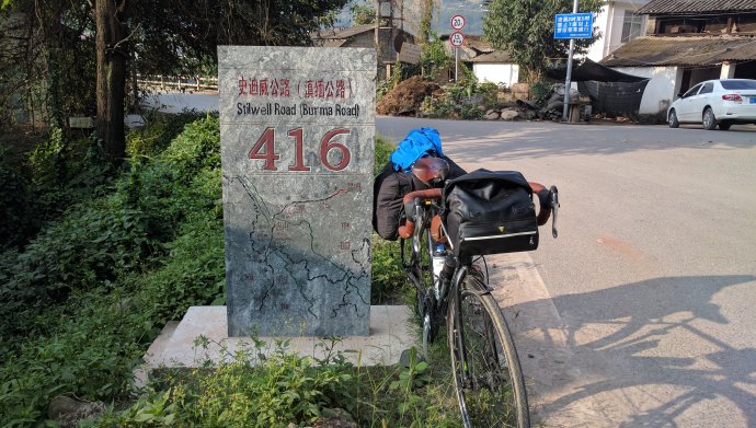
In fact, this milestone is also debatable,the top of the Stilwell Highway (Burma Road) is not very strict. Stilwell Road and Burma Road are actually different,see below.
It can be seen from this map that the Yunnan-Burma Road(滇缅公路) refers to the road from Kunming to Mandalay via Dali, Baoshan and Wanding(畹町), which was constructed by Chinese from 1929to 1939. The Stilwell Road(史迪威公路), from Ledo of India to Myitkyina of Burma, was divided into two lines that converged with Burma Road. This road commonly known as “Highway of China-Indian”, which was built in 1944 when Indian troops counter-attack northern Myanmar. The main force of road construction was US Army Engineer troops. Why the “China-Indian highway” was also called “Stilwell Highway” ? When it was fully opened in early 1945, General Stilwell, chief of general Staff of the China Burma India Theater (中缅印战区), Commander of the US Army in the theater, failed in the struggle against Chiang Kai-shek’s dominance. He was dismissed three years ago and returned gloomily. To show the demeanor of a victor, Mr Chiang (蒋介石) announced the designation of the highway between China and India as “Stilwell Highway”. Due to the connection between Stilwell Road and Burma Road, the names of these two roads can be commonly used. Milestones are clearly marked by customary rather than strictly named.
In any case, this monument is the second landmark associated with the Burma Road(滇缅公路) on this trip, which is very gratifying. It is commendable that there have been such milestones on the mountain road over the next 30 kilometers. In order to commemorate this road,the local people had done their best.In fact, they couldn’t fail to do so. Because it crossed the bridge from here to Shengbei Bridge(胜备桥), the milestones were established along the way. The length of36 kilometers of road, it is the road that the Yangbi county contracted to build. During this period, Almost all the people in the county were out for this part of the road. The construction of this road was the biggest event in local history.
It was 9 am, we leaned the car against the landmark to take pictures. At that moment, we had no idea of the difficulties of the following roads and no intuitive understanding of the hardships of the road builders. But the whole day after that , when we were hobbling along this road that was all artificially dug out, we were exhausted and often lamented the strength and greatness of that generation. There were even many times we need to stop to calm ourselves. However, this is still the case. At this time , we still stood in the bridge– Yangbi Bridge(漾濞桥).
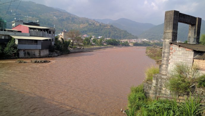
On the side of the highway bridge,you can also see the back of the bridge. On the east bank, the bridge door that used to place the steel cable was still standing. The reef objects in the west side near the river were the remnants of the bridge gate. At the ancient times, the Yangbi Bridge (漾濞桥) was standing here. Local people also called it “Suspension bridge”, It is the most important bridge though its form is very simple. The bridge was replaced by a stone column plank bridge, which was destroyed by flood waters. When it was rebuilt, it was changed to a cable-stayed bridge and dismantled in the 1970s.
Across the river, from the town of Hexi (河西镇) Road to the west.The mountains are rolling. The road hovered like a belt. It was one of the few sections of the old Burma road that remained its character during the war. Two days later, we will finally meet with the original Burma Road.
http://blog.sina.com.cn/s/blog_5379fe130102ww6a.html

