 7 Days GolfingTour
 8 Days Group Tour
 8 Days Yunnan Tour
 7 Days Shangri La Hiking
 11 Days Yunnan Tour
 6 Days Yuanyang Terraces
 11 Days Yunnan Tour
 8 Days South Yunnan
 7 Days Tea Tour
 8 Days Muslim Tour
 12 Days Self-Driving
 4 Days Haba Climbing
 Tiger Leaping Gorge
 Stone Forest
 Yunnan-Tibet
 Hani Rice Terraces
 Kunming
 Lijiang
 Shangri-la
 Dali
Dali
 XishuangBanna
 Honghe
 Kunming
 Lijiang
 Shangri-la
 Yuanyang Rice Terraces
 Nujiang
 XishuangBanna
 Spring City Golf
 Snow Mountain Golf
 Stone Mountain Golf


 What Our Customers Say?
 alt="Market Days in Menglian and Townships, Puer"
/>
alt="Market Days in Menglian and Townships, Puer"
/>
Yunnan Cycling Tour along The Burma Road and Stilwell Road from Wayao to Huitong Bridge
October 8th Pupiao Town——Huitong Bridge(58KM)
Unlike the north, the autumn rain here is not cold. But I am still sorrowful because the rain does not rest all night. Sitting on the balcony of the hotel, I hope that the Dragon King will receive the magic power as soon as possible. The wait was beyond 10:00, watching as lunchtime approached.
According to their description, the planned ride today was probably the most intense of the entire route. If we set out at this time, we must fight again on the dark mountain road at night.
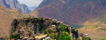
In particular, there is no county or hotel at the end of this trip, and there is a great risk of finding a place to live. Therefore, the only choice is to resort to external forces. The street found a minivan and hitchhiked to the high-speed exit near the town of Pumu. Start riding. The decision to take back 19 km2 saved about an hour or so, barely putting himself back on track. Nothing new, climbing the big slope again became a prelude to the cycling task. A few kilometers later, into a busy town, the center of the intersection, a stone tablet marked the town’s name: “707” (七零七).
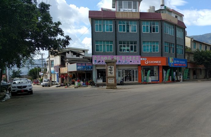
Seven o seven, a somewhat odd name. Generally speaking, this digital place name is often military related, however, the town is named after the Burma Road-it is located in the old Yunnan-Burma Road 707km milestone. Now the Yunnan-Burma Road less than 707 km. But the passage of flesh and blood left a permanent mark here.
For a long time, I didn’t pass by the bustling towns during the day. I quickly found a repair station and assembled the fender fixing screws that had been thrown away on various seesaw roads for several days. set off! Just passing the road from Baoshan to Pudong is a 320 national road that coincides with the Yunnan-Burma Highway.
As expected, it is still building roads. Thankfully, this section of the road cannot ride. Since the beginning of Pupiao(蒲缥镇), all the road sections in the current ride plan have been abandoned after the State Road has been straightened. To the west of 707(七零七), heavy stacking is the main vein of Nushan Mountain(怒山). Afternoon yesterday afternoon, the image of Nushan on the banks of the Li River was still in front of the sky. Now, it is time to climb over this mountain.
All the way to the west, the mountains are beautiful, but they are also pleasing to the eye. The villages in this area apparently appear to be Han style, and the architectural styles are quite different from the Yi ethnic villages seen in the two days.
According to textual research, the Baoshan area is the birthplace of the Dai nationality (that is, the main Thai nationality of Thailand). But now Baoshan is a rare area in the west of Yunnan, mainly surrounded by Han nationality, surrounded by Tibetan, Yi, Dai and wa communities. This is the result of thousands of years of Han nationality migration since the Western Han conquered the Ailao country and set up Yongchangjun(永昌郡). Before the naturalization of Xinjiang, the land was regarded as the westernmost end of the Han nationality in the Chinese territory. The most western part of it is Tengchong, which is known as the extreme west border town.
While thinking of leaps and bounds, while riding casually on the mountain road. The relief lasted only about half an hour and was interrupted by the decisive sight ahead.
This place is working on the road again?
Two hitchhikes have been made these days to avoid the G320, which is under repair. But why is this old Yunnan and Burma Road, which has crossed the mountain of anger, also being built?
Grumbling people, passing a black smoke rolling road construction machinery, a section of yellow dust desert construction section, in addition to cover the nose, grip the handlebars, but also how?
The following dozens of miles, is really the former “dust” such as a dream, unthinkable, skipped mention it.
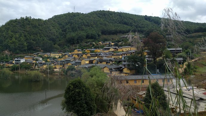
More than one o’clock in the afternoon, come to a small village, which is about Taiping Township(太平乡), and stop in a place where the sales department, the hotel and the tea house are in one place. All over the body had already covered with a layer of red dust, but not the true colors. As for the car, it couldn’t be seen. Dust the dust, wipe the chain, and sit in the store. After a few chat with a few tea guests, it was quick to be surprised to find that when the speed of speech was a little faster, it was impossible to understand each other, so we explored the language of the province in depth…
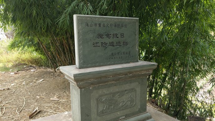
It is refreshing to drink aimlessly, and continue drinking. Taiping Township is located at the waist of the mountain. It rises slightly from Pingxiang to the mountain, and the road is slightly better. Since the appearance of a document protection monument of Shidian Anti-Japanese Jiangfang Site Complex, there have been more and more relics along the way.
In May 1942, the Allies were still in the crusade. The Chinese expeditionary army was defeated for the first time in Burmese war. Tens of thousands of Chinese soldiers are still in the tropical rain forests of the wild man mountain in the north of Myanmar. While the Japanese army went all the way into the west of Yunnan. Between the month and the month, the whole west of Nu River was lost. Shidian County(施甸县), located on the East Bank of the Nu River, became the forefront of the confrontation between the Japanese army and the Japanese army. It was also a gathering place for the southern line attack group during the two years after the big counter offensive. So a large number of Anti Japanese War relics were left in the County.
At that time, the National Army built a large number of river defense positions near the Nu River, and so far there are still a few. The week before writing, I just read the best anti Japanese TV drama “My regiment leader and my regiment” 《我的团长我的团》in ten years. The main plot of the play took place before and after the confrontation between the two armies of China and Japan.
At this point, it is more complex to recall the journey through the fury mountain. The cannon troupe in the play is not entirely fictitious, and the examination of the force may be given in the epilogue of this travel note. It may be stationed somewhere in the site.
Of course, there are not many ideas in mind when riding these ruins. There are more and more intense excitement and hope. For the hilltop pass is approaching, and we shall see the mountain and the river.
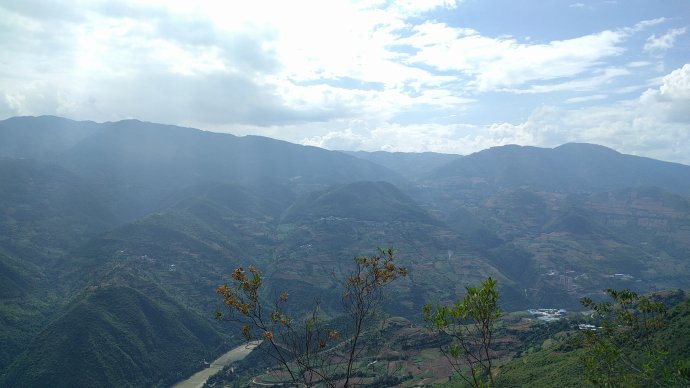
After an hour’s climbing to the summit, Nujiang Grand Canyon(怒江大峡谷) was so impressive.
Different from the open weather when the Lancang-Mekong River Valley(澜沧江峡谷) was first seen yesterday, the Nujiang Valley in this area has high mountains on both sides and deep valleys. The mountains on the other side of the river seem to be within reach, and there are even feelings that will come at any time. These seemingly aggressive mountains are the famous Gaoligong Mountains. The Gaoligong Mountain(高黎贡山) in front of him is the Songshan Mountain(松山), which has been a nightmare for many years.
At the top of the mountain, the slope is steep and the road is narrow. Go down the hill and find a safe place. Parking carefully look at the Huitong Bridge on the opposite side of Songshan and the foot of Nu River.
Songshan, visited 8 years ago, but it was a ride from behind the mountain. But this time it was across the river.
“My regiment, my regiment”《我的团长我的团》, the Dragon articles meet on the river defense positions one after another. Is this the same?
In the summer of 1944, how many soldiers walked along the road under the wheel, crossing the Nu River and spilling blood on the steep slopes on the other side of the river. The names of Yindengshan(阴登山),Zigaodi(子高地),Gunlongpo(滚龙坡) was coming to my mind.
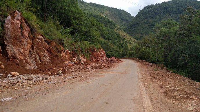
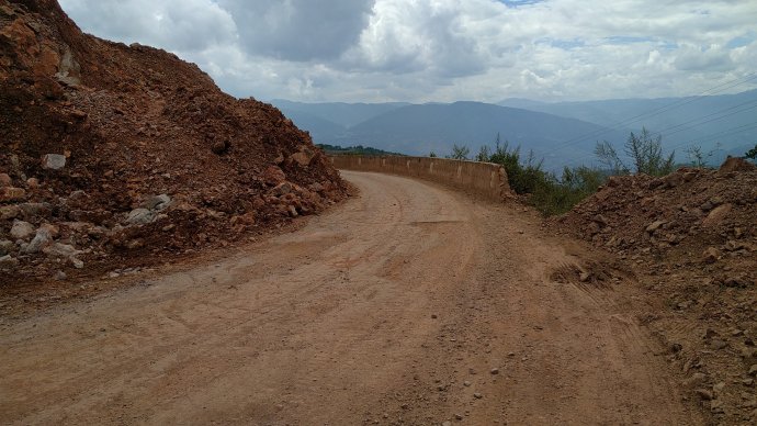
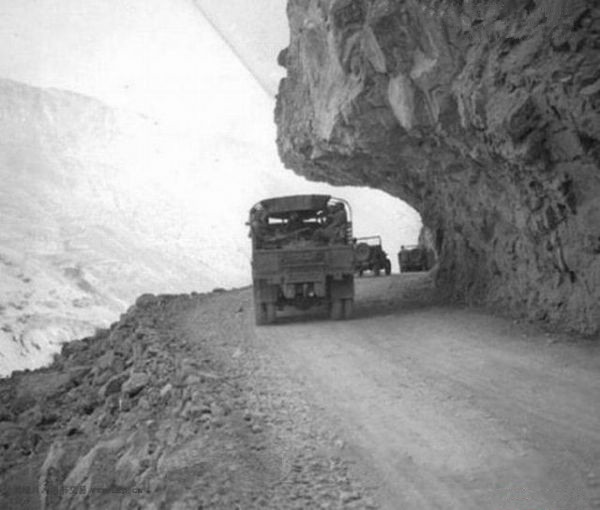
When the mind regained its intention and continued to move forward, it suddenly found that the road conditions had changed. Although the road to mountain has been riddled with numerous holes, it is still able to identify the base of the asphalt road; but since the top of the mountain, it has become a tangling road.
Fortunately, the road was not repaired at the end of the road and the dust was not so big. The mountain facing this side of the Nu River is extremely steep, and the road has to hover over the mountainside. Judging by the road conditions of the mountains, the following photograph taken in early 1945 should be the road ahead.
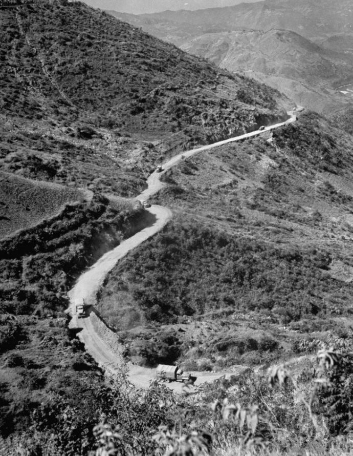
There is an unspeakable pain on the downhill path of the stone road. In the last few days, many times on the road in Tong Shi Road, has mastered the skill of controlling the car on this road, so this time did not control the speed of the downhill too intentional, the faster speed made the turbulence become more and more severe, until the liver and intestine are broken, the hands and feet are numb. Southwest Mandarin does not distinguish between front and rear nasal sounds, so in the past, “Tong Shi Lu”, in the local population, should actually be written as “rock and stone road”.
At this point, the individual also feels that the stone road is a more accurate name. All the way to the ball, at noon, at 707 just tightened the mudguard finally decided to leave in the endless bumps. In the words, the two fenders were crackled on the way, and they always felt that the cars were going to be scattered, and the world seemed to be cleaner and more dedicated to the stone road after they were taken apart.
The top of the hill is down and the road is dizzy, but as long as we turn around, we can see the majestic appearance of Songshan. At the beginning, I always felt that I could see Songshan at any time.
It was a gift from a dangerous journey, but I could think of something else slowly. The reason why the Japanese army built an iron bucket of defensive work in Songshan Mountain was called the “Gibraltar of the East”. It was precisely because of the control of Songshan that it could control the Yunnan Burmese highways over a hundred miles around the Songshan. At the moment, on the East Bank of Nu River, we can see the Pine Hill at any distance. That is to say, the whole East Coast Highway is under the fire coverage of the Japanese troops in Songshan. This also explains why the 1944 attacks on the Songshan and the Dragon Ling were needed to mobilize tens of thousands of people to carry their shoulders, bypassing the Yunnan Burmese highway that was blocked by the Japanese army and transporting supplies from the mountain path to the front. Matsuyama’s importance has long been known in books, and now it is time to walk through it and get to know it again.
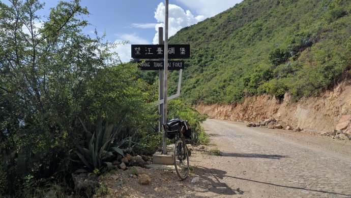
Through the ruins of Dashantou Artillery Position(大山头炮兵阵地), Xiaotuanshan High Artillery Position(小团山盟军高炮阵地) and Dafengziwo Pillbox(大蜂子窝碉堡等处遗址), we tried to visit the fortress of the Wangjiang platform along a path.
At the foot of the mountain, the road was forbidden by construction and had to go around the mountains. The narrow cement road, estimated to have been built without any consideration for cycling, was often unimaginably steep. But the detour was small, seeing trenches, foxholes and other fighting remains on the hillside.
The Haipo mountain(孩婆山) and the old ferry below were the only places where ground fighting took place east of the Nu River throughout the Western Yunnan War of Resistance. In 1942, the Japanese troops attacked the Nu River and were unable to cross the river on a large scale because of the destruction of the Huitong Bridge(惠通桥), so they sent out hundreds of troops. In the upper reaches of Huitong Bridge a ferry-that is, the old ferry-cross the east coast.
At that time, the East Coast garrison was in chaos after a major defeat, but still engaged in fierce fighting with the Japanese troops in the two places, and completely wiped out the enemy headquarters across the river, and then firmly refused to defend the enemy forces in the West Bank.
Therefore, Haipo Mountain(孩婆山) became one of the important river defense positions. Interestingly, the inexplicable name, though now an official name, is actually named by a misunderstanding. The original name of this mountain is “Black Slope Mountain”(黑坡山). However, as mentioned earlier, the local accent is slightly unique. It is estimated that the cartographer at that time, according to his own interpretation, marked “Black Slope Mountain” as “Haipo Mountain”, which has been used since then.
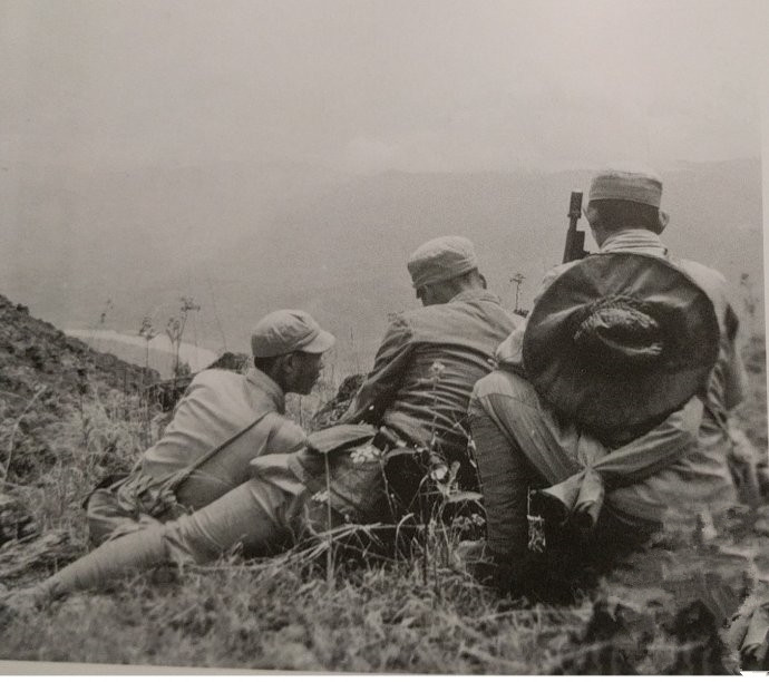
Then the question came. Did the army have no native speakers of dialect at that time? That’s true. There are few Yunnan people in the sequence of the expeditionary forces in the west of Yunnan. The expeditionary force is mainly based on soldiers from Sichuan(四川), Guizhou(贵州) and Hunan(湖南). Where did the Yunnan people go?
During the war of resistance, for some reasons, the main force of the Dian army was transferred to Shanxi(山西), Shandong(山东), Hunan(湖南) and Jiangxi(江西). In addition to the 60 army that was quickly splinter up in the late part of the war of resistance against Japan, most of the soldiers in the Yunnan army were fighting outside the province. During the 8 years, Yunnan sent about 400 thousand troops to the various fields of war in the country. The number of casualties was over 100 thousand, and the number of troops sent to the central army and other troops was about 50 thousand.
At that time, the total population of Yunnan province was only about 9 million, but the number of male servants was only one million, almost two. Needless to say, a lot of labor was used for the construction and maintenance of the Burma Road, and after the counterattack began, a large number of transport facilities were being used. This can also explain why a lot of women and children can be seen in road workers, logistics, and even guerrilla forces.
The peak is planning to build a cemetery. It is said that the remains of 347 expeditionary soldiers from Burma will be buried here. These soldiers belonged to the famous New Army (commander Sun Liren), who died in the battle of Myitkyina in 5-8 months in 1944. However, the funeral seems to be in a bad way and I don’t know where to go. The more than 300 remains are still lying in a broken warehouse in Myitkyina, but it is much better than being buried in a pig farm.
Climbing over the mountain, it is Dapingzi Village(大坪子村) which is quiet and peaceful. People who are walking in such a beautiful village should be happy, but now I can’t do it. According to a meritorious monument at the entrance of the village, there was a bacterial bomb attack on the other side of the Japanese army, and the entire village died. Perhaps starting from here, sad emotions began to gather slowly in my heart.
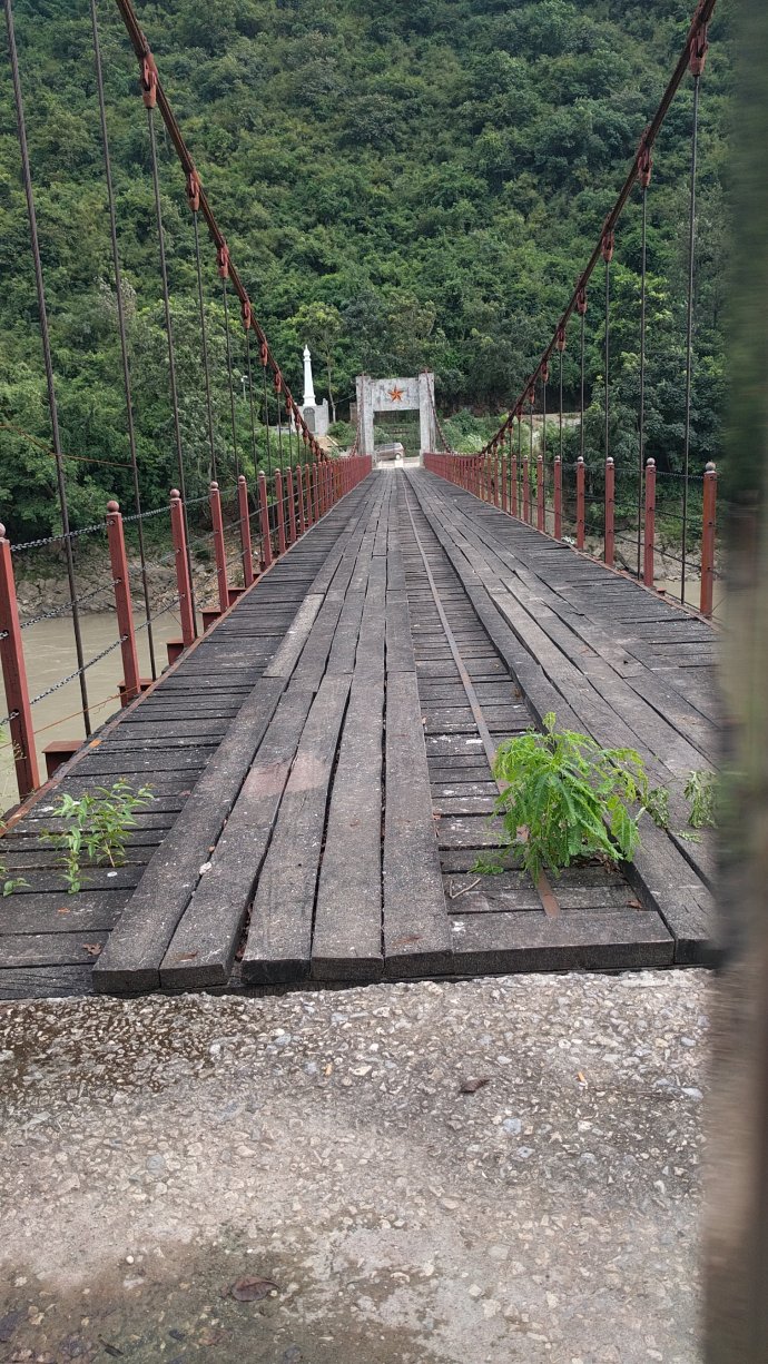
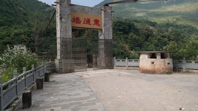
From Dapingzi village to the dangerous mountain, it came to a residential point on the riverside. The word “residential point” is used because it is not a town, nor can it be seen on the map. Of course, there are no permanent residents. There are only two snack bars, two shabby restaurants and two hotels. If we have to speak of the permanent resident, we are stationed in the armed police force of about a company to defend Jiangqiao Nu River. It is not Huitong bridge(惠通桥), but the Hongqi Bridge(红旗桥) built in the rear.
Turn left at the door of the Armed Police Station and lead to the Hongqi Bridge that is several hundred meters away. On the other side of the turn, there was a path full of fallen leaves, a simple signpost at the intersection, and the words “Hui Tong Bridge” were impressively drawn.
On the way down the mountain, although the Huitong Bridge has been overlooked numerous times, it is still difficult to be excited even before it reaches the truth.
Cart, walk along the lonely path. Just a few tens of meters, but it seems that it is passing through decades of time, through the thick smoke and blood. Every step seems to be approaching the history of glory and humiliation. Every step we take, it seems that we can hear the broken bones….
But after all, it’s just a few tens of meters away. When the bridge doors, steel cables, and bridges are all laid out, their thoughts are so thick that they feel very difficult to walk. When he threw the car on the side of the road, he climbed the bridge.
It is also a coincidence that although this is not deliberate, this photograph now looks like it can correspond to the following old photograph. It was Wei Liqiao, the commander of the expeditionary force who returned from the Jiangxi shore after the preliminary restoration of Huitong Bridge in October 1944.
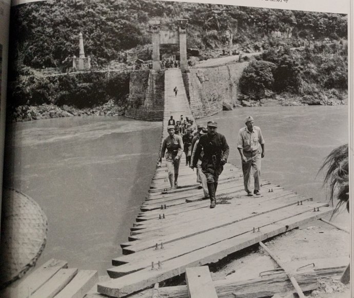
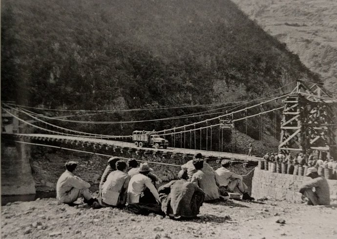
Huitong Bridge(惠通桥), originally built as a iron bridge, was built in the Ming Dynasty and has been the only access across Nu River. The steel cable suspension bridge was rebuilt in 1935. The importance of Huitong bridge to the Burma Road is hard to describe simply.
However, if only one thing can be used to represent the Burma Road, it will undoubtedly be Huitong bridge. It is not because Huitong bridge is the only bridge on the Burma Road(滇缅公路) so far. It is not because Huitong bridge has crossed the most difficult cut on the road, but because the Chinese army and the people have too many tears in the bridge. Huitong bridge witnessed the defeat and despair, resistance and sacrifice of the Anti Japanese war in western Yunnan. Huitong bridgehead, the two sides of Nu River, has gone through a number of unreturned figures, haunting how many sad and hopeless cry. The wheel of great history rumbled over here, just like the surging rivers in front of the eyes, and the passing of the war.
In May 4, 1942, after the defeat of the northern Burma Army, the Japanese advance troops replaced civilian clothes in the refugee troop fleeing east to the West Bank of Huitong bridge. At this time, a engineer company commander who was ordered to stay at the bridge head and ready to explode the bridge was firing guns to straighten the order.
When the Japanese heard the shots, they thought they were exposed. The enemy troops arrived and the commander of the Corps of engineers ordered the destruction of the bridge. According to the situation at that time, if the Japanese army mixed the river and took Huitong bridge, then the West Yunnan, which was in a state of disorder, would not be guaranteed, and the collapse of Kunming and even the whole province of Yunnan was only a matter of time. If the situation develops, the strategic depth of the national government of Chongqing will be compressed to the situation that cannot be maintained, either to fall into the local regime in Shaanxi and Gansu, or to simply surrender. Fortunately, Huitong bridge, in a sense, saved the country in a sense.
Unfortunately, hundreds of refugees who were not allowed to cross the river were killed by disappointing Japanese troops on the bank, the first bloody sacrifice to the bridge. Two years later, the expeditionary force counterattacked West Yunnan, three hit the Dragon tomb, and nine attacked Songshan. The purpose of the expedition was to seize control of the two sides of the Huitong bridge in order to restore the Huitong bridge. Half a year’s fierce battle, tens of thousands of casualties has become the last and biggest sacrifice of the bridge. If the number of civilians slaughtered during the Japanese occupation period is counted, the number of civilians who have been reduced to the number of fish in the dragon’s sawing hills and the total number of tens of thousands of Japanese troops destroyed will be counted. Bones, I do not know how to build a few Huitong bridge.
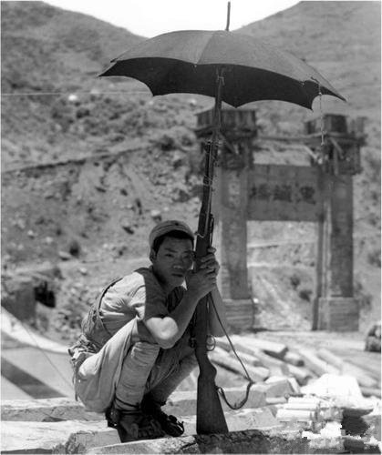
As the symbol of the Yunnan Burma Road and the target of many years of fierce contention, Huitong bridge naturally impress every person passing through the year, and the photographer is no exception. So many old photos of Huitong bridge have been seen so far. The picture below was taken roughly at the same time as the picture above, but the location was on Songshan on the other side of the river. At this time, the Huitong bridge has been initially repaired, but it can only be passed on foot. The transporting people are crossing Nujiang River and crossing Songshan Mountain(松山).
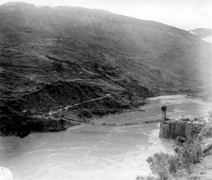
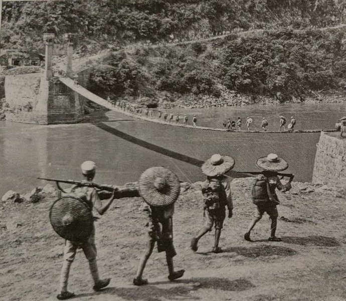
As for this photo, it was later estimated that by the end of 1944 or early 45, the humble footbridge had been restored as a cable suspension bridge for traversable cars. Notice the bridge door on the east coast, which was blown up in May 1942 as a temporary wooden substitute.
The next two photos were probably taken in the same location, on the side of the east bank bridge. And at this moment oneself, also is standing roughly in the same position.

The small tree in front of us was overwhelming. It was planted a year ago by veterans of the Sino-U.S. resistance. On the right side of the tree, the small tree that once was equally unbearable at the bridge in the old photographs is now enshrouded. Under the tree, there is a river breeze coming from Xu, and the waves are rolling, listening to bleak deciduous trees, whispering the iron ropes, all echoes of history; holding on to this kapok tree, sighing with amazement, I would like to spring up every year, above the canopy, the hero blossoms. It must be red and bloody…Independent bridgeheads, those tears that were once found in Xiaojianshan(小尖山), Daixishu(大栗树), Gongguo Bridge(功果桥) and Shengbi Bridge(胜备桥), finally flowed down. For this river, this mountain, this bridge, even more troubled countries.
Tidy up the mood; turn the road, through the bridge soldiers after a search, through the red flag bridge across the river to inspect the west end of Huitong Bridge. The bridge is still there, but the people at the bridge do not know where it is.
Not far from the west of the bridge is another famous landmark, Laohuzui(老虎嘴/Tiger Mouth). This place is also very common in photos. We often use it to show the steep road. Nowadays, narrow earth roads have been widened as tar roads, and the guardrails on the Linjiang side seem to be very common.
Back to the east of Jiangdong and stay in a hotel. I didn’t expect the conditions to be good, at least independent bathroom. This night will be on the Bank of Nu River, Huitong bridge head, waiting for the golden horse to dream.
Chinese Source: http://blog.sina.com.cn/s/blog_5379fe130102wxb2.html

