 7 Days GolfingTour
 8 Days Group Tour
 8 Days Yunnan Tour
 7 Days Shangri La Hiking
 11 Days Yunnan Tour
 6 Days Yuanyang Terraces
 11 Days Yunnan Tour
 8 Days South Yunnan
 7 Days Tea Tour
 8 Days Muslim Tour
 12 Days Self-Driving
 4 Days Haba Climbing
 Tiger Leaping Gorge
 Stone Forest
 Yunnan-Tibet
 Hani Rice Terraces
 Kunming
 Lijiang
 Shangri-la
 Dali
Dali
 XishuangBanna
 Honghe
 Kunming
 Lijiang
 Shangri-la
 Yuanyang Rice Terraces
 Nujiang
 XishuangBanna
 Spring City Golf
 Snow Mountain Golf
 Stone Mountain Golf


Xiaowan Dam Tourist Area of Mekong River in Fengqing County, Lincang
Chinese Name:凤庆小湾大坝旅游区
English Name: Xiaowan Dam Tourist Area of Mekong River in Fengqing County, Lincang
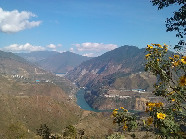 The Xiaowan Dam (simplified Chinese: 小湾坝) is an arch dam on the Lancang (Mekong) River in Nanjian County, Yunnan Province, southwest China. The primary purpose of the dam is hydroelectric power generation and it supports a 4,200 MW power station. Constructed between 2002 and 2010 by Huaneng Power International at a cost of ¥32 billion (nearly US$3.9 billion), it is the world’s second highest arch dam at 292 m (958 ft). It is also third highest among dams of all types behind Jinping-I and Nurek and the third largest hydroelectric power station in China.
Background
The feasibility study for the dam was completed in 1992, with it as part of the Lancang River Project. In 1995 the report was reviewed and approved by the Chinese government. Three years later in 1998, a consortium to fund and construct the dam was organized. In 1999, preliminary construction (roads, bridges, river diversion) began. Official construction on the dam started on 1 January 2002. The river was diverted by November 2003 and concrete pouring began in 2005. The river diversion was closed and the reservoir began to impound in November 2007.[1] The first generator was commissioned in September 2009 and the dam was complete in March 2010.[4][7] The last of the six generators went operational on 22 August 2010.[8] The creation of the dam’s reservoir submerged 55,678 ha (137,583 acres) of land and displaced 32,737 people.
Specifications
The Xiaowan Dam is a 292 m (958 ft) tall and 902 m (2,959 ft) long double-curvature arch dam. Its crest is 13 m (43 ft) wide while the base sits at 69 m (226 ft) in width. The dam’s crest is at an elevation of 1,245 m (4,085 ft) while the normal reservoir level is slightly lower at 1,240 m (4,068 ft). The dam’s reservoir has a normal storage capacity of 15,043,000,000 m3 (12,196,000 acre·ft); of that capacity, 9,895,000,000 m3 (8,022,000 acre·ft) is active (or “useful”) storage. The dam traps water from a catchment area covering 113,300 km2 (43,700 sq mi). The surface of the reservoir at normal level covers 190 km2 (73 sq mi).
Helping to control floods, the dam has two spillways, 5 gates near the crest and a tunnel on the left bank. The gates can discharge up to 5,130 m3/s (181,164 cu ft/s) while the tunnel has a maximum discharge of 4,884 m3/s (172,477 cu ft/s). In the middle portion of the dam, there are six orifice openings that can discharge 6,500 m3/s (229,545 cu ft/s). In addition, the dam can release additional water and sediment with two bottom outlets. All of the dam’s outlets including the power station give it a maximum flood discharge of 20,709 m3/s (731,331 cu ft/s).
On the right bank of the dam is the power station intake which receives water into six 9.6 m (31 ft) diameter penstocks which each feed a 700 MW Francis turbine-turbine in the underground power station. The drop in elevation from the intake to the turbine affords a maximum hydraulic head of 251 m (823 ft). Once discharged by the turbine, the water is sent down one of two 18 m (59 ft) diameter tailrace tunnels towards the river.


