7 Days GolfingTour
 8 Days Group Tour
 8 Days Yunnan Tour
 7 Days Shangri La Hiking
 11 Days Yunnan Tour
 6 Days Yuanyang Terraces
 11 Days Yunnan Tour
 8 Days South Yunnan
 7 Days Tea Tour
 8 Days Muslim Tour
 12 Days Self-Driving
 4 Days Haba Climbing
 Tiger Leaping Gorge
 Stone Forest
 Yunnan-Tibet
 Hani Rice Terraces
 Kunming
 Lijiang
 Shangri-la
 Dali
Dali
 XishuangBanna
 Honghe
 Kunming
 Lijiang
 Shangri-la
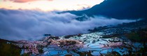
 Yuanyang Rice Terraces
 Nujiang
 XishuangBanna
 Spring City Golf
 Snow Mountain Golf
 Stone Mountain Golf
Gaoli Gongshan Mountain Hiking Tour from Baihualin to Tengchong
Gaoligongshan is the home of many endangered species of animals and plants. It is also the native home of the eight famous flowers in Yunnan. There is a big azaleas tree depicted as “ azaleas King in the world” in the area. In spring, the azaleas are in full bloom and spreads out the hillside and valleys. In addition, waterfalls, snow mountains, lakes and rivers can be easily found there. Gradually, it becomes the paradise for photographer with its fabulous scenery.
Gaoligongshan Nature Reserve is located in the south of Qinghai-Tibetan Plateau and the fault zone of India Plate and Eurasian Plate, which generates the steep and lofty peaks with minimum altitude of 4000 meters. Therefore, the region enjoys a vertical climate and natural landscape due to its unique terrain. The climatic condition allows a complete transition from temperate to tropical forest that is rare in the world.
Waterfalls and Stacking Waters
Gaoligongshan is the watershed of Nu River and Irrawaddy River and there are more than 80 rivers flow into the two rivers. Numerous waterfalls and stacking waters are spread over the area due to its great difference of elevation, such as Baihualing Yinyang Valley Third-Level Waterfall, Beauty Waterfall, Gaojiaoyan Falls, Dabai Hekou Fall. At noon, valleys are painted as a marvelous picture under the sunshine. the waterfalls are pouring down from the dense bosk, lashing against the rocks with a splash.
The Ancient South Silk Road
The renowned South Silk Road is well preserved in the area, which could be dated back to 4th century BC. The ancient road stretches from Chengdu, the capital of Sichuan to Burma, India and Afghanistan via Kunming, Dali, Baoshan and Gaoligongshan. The road is about 1.5-2 meter wide and paved with stones full of moss. The scenery along the road is attracting and many historic sites are scattered nearby. The section of Gaoligongshan starts from Baihualing and winds its way up to the mountain. You may also spot the faded and blurry impress of horse’s hoofs and find the rusted horseshoe as if you witnessed the rushed caravan with melodious bells and the rhythmed voice of horse’s hoofs.
The Adventurous Hiking Route
Day1- Kunming-Baihualing in Baoshan(Over 600km, about 10 hours)
I got up at 7:00 and departed from Kunming for Dali, and proceeded to Lancang River along Dali-Baoshan highway. Then headed to Gangdang by Nujiang River.The natural scenery of Lancang River and Nu River is within my sight. Later I Kept on trekking up from Gangdang to Dayutang Village(about 1500m) in Baihualing and stayed overnight in a local family, enjoyed some local cuisines.
Day2-The Primeval Forest Hiking(7km)
I rode to Zangtanghe Parking lot and started hiking from a primeval forest,panted my way to the outlet of the forest and went over some valleys. Finally, I reached the Big Waterfall where there is a natural hot spring. I photographed the amazing view, took off my clothes and had a enjoyable bath in the hot spring. I moved forward to the Beauty Fall, catching terrific natural sight along the way. Then returned to the parking lot.
Stay overnight in Baihualing.
The forest is a tropical rainforest with the maximum elevation and latitude. The species of plant are various. The lofty trees with big roots can be found everywhere. The climbing plants grow wildly and attach to the branches of the trees. The reserve is also abundant with herbaceous plant and the old-growth fern. I felt like I was got back to Jurassic period.
Day3- Jiujie- Linjiapuzi(22km, about 10-12 hours)
I got up at 6:00 and get things ready and prepare to hike before 7:00. Today is a miserable day as well as a funny day. We will take the spiritual and physical challenge. I winded my way up to Ertai Slope from Jiujie. It’s not a completely ascending route. After climbing up a while, I took it easy on the downward slope, went through Dafengbao, Gangfang, Huangzhu River and reached Yongding Bridge. After the bridge, the elevation has an obvious increase and it would snow in Winter above 2800m. Therefore, the route is more challenging. But the picturesque scenery with azure sky, floating cloud, luxuriantly green jungle and dodging animals will ease your pain and tire. Finally, I caught the sight of the peak and I knew I was near Nanzhaigongfang. After replenishing some food and had a short break, I continued my journey. Went over a mountain ridge and I saw a valley in Tengchong. Later quickly got out of the pass with strong wind and moved westwards along the path in the forest. After 3-hour descending journey, I finally get to Linjiapuzi in Tengchong. When I looked back my way and I’m so inspired.
Day4-Free Activities in Heshun Town
Now I return to the human society, I whispered. I got around the streets and alleys, admiring the old houses and enjoying a cup of fragrant tea at an antique teahouse. Stay overnight in Tengchong.
Day5- Tengchong-Kunming(680km, about 10 hours)
Packed my bag and went back to Kunming via Longchuan River Bridge, Lujiang Dam, Baoshan and Dali. You can stop in Dali if you still want to explore more. Trekking on Cangshan Mountain is a good option.
Equipment: A pair of hiking shoes,fleece Jackets, combat trousers, a raincoat, a bag, a walking stick, head lamp, vacuum bottle, some snacks like chocolate and cookies, a bathing suit, a camera.
Notes
1. Since it’s a long journey and challenging, it’s suggested to prepare high-energy food, a bottle of water, a walking stick, fleece Jackets, a kneecap, a head lamp, and do not push yourself to limits.
2. Hikers should make a reasonable daily plan according to their physical strength. Usually, you should walk 4-5 km per hour and have a rest under a tree or pavilion for 15 minutes.
3. Apart from the necessities, try to shrink your bag. Don’t forget to wear a sunhat and take with a bottle of water in case of sunstroke.
4. It’s suggested to hike with others and take care each other as Gaoligongshan Reserve is undeveloped with vast wild animals.
5. Carry with a raincoat and a warm clothing as the weather is changeable.