 7 Days GolfingTour
 8 Days Group Tour
 8 Days Yunnan Tour
 7 Days Shangri La Hiking
 11 Days Yunnan Tour
 6 Days Yuanyang Terraces
 11 Days Yunnan Tour
 8 Days South Yunnan
 7 Days Tea Tour
 8 Days Muslim Tour
 12 Days Self-Driving
 4 Days Haba Climbing
 Tiger Leaping Gorge
 Stone Forest
 Yunnan-Tibet
 Hani Rice Terraces
 Kunming
 Lijiang
 Shangri-la
 Dali
Dali
 XishuangBanna
 Honghe
 Kunming
 Lijiang
 Shangri-la
 Yuanyang Rice Terraces
 Nujiang
 XishuangBanna
 Spring City Golf
 Snow Mountain Golf
 Stone Mountain Golf
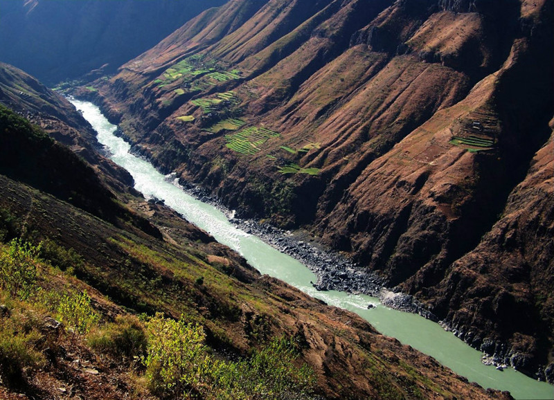
Lancang-Mekong River in Yunnan Province
The Lancang River, known as the Mekong River outside of China, originates from the northeastern part of the Tanggula Mountains in Qinghai Province, China. It flows through Tibet and Yunnan Province before exiting China’s borders where it is then named the Mekong River. The river continues its course through Myanmar, Laos, Thailand, Cambodia, and finally Vietnam, where it empties into the South China Sea near Ho Chi Minh City (formerly Saigon). It is the largest international river in Southeast Asia.
The main stem of the Lancang-Mekong River is 4,880 kilometers long, with a total drainage area of 810,000 square kilometers. Within China, its main stem is 2,161 kilometers long, draining an area of 167,487 square kilometers. The river crosses the Hengduan Mountains, making it one of the world’s most prominent north-south oriented rivers.
 Lancang-Mekong River Meili Grand Canyon in Deqin County, Diqing
The terrain within its basin varies widely, influencing the redistribution of water and heat due to differences in elevation, slope, and mountain orientation. The upper, middle, and lower reaches of the river exhibit distinct natural environments. The basin descends in a step-like pattern from north to south, characterized by high mountain ranges and deep gorges. As the river progresses southward, the spacing between mountains gradually widens.
In Yunnan Province, the Lancang River passes through regions including Diqing, Nujiang, Dali, Baoshan, Lincang, Pu’er, and Xishuangbanna. Upon exiting China at Mengla County in Xishuangbanna, it continues as the Mekong River through Myanmar, Laos, Thailand, Cambodia, and Vietnam, covering nearly 5,000 kilometers before reaching the sea, thus becoming the longest river in Southeast Asia.
澜沧江, also known as the Lancang River, is a typical southward-flowing river that traverses a region encompassing nearly all natural landscapes and climate types except deserts and the Gobi. Culturally diverse, the basin is home to numerous ethnic groups. In Yunnan alone, 16 ethnic minorities, including the Dai, Bai, Buyi, and Yi, reside, with some, such as the Dai, Buyi, and Dulong, being cross-border ethnicities. Each ethnic group’s customs, lifestyle, and religious beliefs are distinct and often integrated with the local natural environment.
The sources of the Lancang River have been described in various ways, with recorded lengths ranging from approximately 4,200 to 4,880 kilometers depending on the starting point. One source originates from the Zhaqu River in the northeastern part of the Tanggula Mountains, specifically the southern slope of Mount Jiaqia Ma (meaning “colorful mountain” in Tibetan) near Mouni Beach in Zadoi County, Yushu Tibetan Autonomous Prefecture, Qinghai Province. Another recognized source, identified by remote sensing expert Liu Shaochuang, lies in Jifu Mountain, Zhado County, Yushu Tibetan Autonomous Prefecture, Qinghai Province, at an altitude of 5,200 meters.
The Lancang River basin in Qinghai Province spans 444.1 kilometers within the province, with a total basin length of 2,055.2 kilometers and a drainage area of 37,482 square kilometers. The basin features over 20 rivers with catchment areas exceeding 500 square kilometers. Major tributaries include the Ziqu and Jiequ rivers. The Zhaqu River flows south into the Tibet Autonomous Region, with an annual average flow of 148 cubic meters per second at the provincial border and a natural drop of 1,544 meters within the province.
The climate in the Lancang River source region is characterized by cold temperatures, dryness, strong winds, intense radiation, a prolonged cold season, and no absolute frost-free period. The average annual temperature ranges from 6.0°C to -4.0°C, with most areas below 0°C. Precipitation decreases from southeast to northwest, with eastern areas receiving over 500 millimeters of annual rainfall and western areas around 250 millimeters. Precipitation is sparse in the cold season and abundant in the warm season.![]()
River Channels and Hydrology
The Lancang River, known as the Mekong River beyond China’s borders, belongs to the Pacific Ocean watershed system. North of Chamdo, it splits into eastern and western sources. The eastern source, Za Qu, stretches 518 kilometers, while the western source, Ang Qu, spans 364 kilometers.
Upper Reaches: The upper Lancang River main stem is approximately 565.4 kilometers long. Within Qinghai Province, the main stem stretches 448 kilometers, characterized by wide valleys, developed river islands, and extensive floodplains with gentle currents. The average gradient of the upper Tibetan segment ranges from 4.0% to 4.5%, peaking at 10% to 15%, which is 10 to 15 times higher than the overall average gradient of the main stem. This section features a well-developed drainage system, with main and tributary streams intersecting diagonally, forming a “branching” pattern.
Middle Reaches: The middle Lancang River flows through high mountain gorges, characterized by deep-cut V-shaped valleys. The river system follows faults, with shorter western tributaries intersecting perpendicularly, forming a “non” pattern and belonging to a “feather-shaped” water system.
Lower Reaches: In the middle to lower mountain and wide valley terrain, the river maintains a predominantly V-shaped profile, varying in width along its course. The valley width ranges from 150 to 300 meters, reaching up to 800 to 1200 meters at maximum points, while the water surface width ranges from 50 to 100 meters, up to 100 to 150 meters at maximum points. The average gradient of the riverbed is 0.9%, reaching a maximum of 8% to 11%. The development of the valley and the distribution of the water system are still influenced by the “broom-shaped” mountain system in the southern part of the Hengduan Mountains, with atypical water system characteristics.
From the mouth of the Nan’a River to Bankong Long, there are a total of 100 dangerous rapids, with 54 large ones. The main valley section still retains a V-shaped profile, with a stable riverbed and a single channel, averaging a gradient of 0.42%. The main mountain ranges on both sides are mainly oriented north-south, with tributaries developing east-west and intersecting diagonally with the main river channel. Overall, the water system characteristics are atypical.
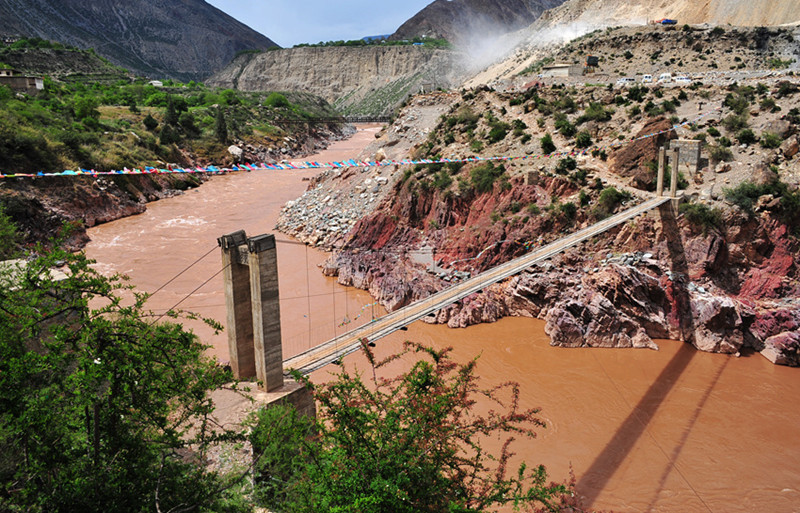 Lancang-Mekong River Meili Grand Canyon in Deqin County, Diqing
From Bankong Long downstream to the Cambodia-Laos border, the Mekong River flows along the edge of the Hele Plateau. From Huisun to the mouth of Nantong River, the eastern bank faces the windward slope, the largest rainfall belt in the entire basin, with a well-developed water system and continuous large tributaries joining the main stem. The western bank faces the leeward slope of the Hele Plateau, with less precipitation and underdeveloped water system, almost no major tributaries join the main stem. Therefore, the watershed in this section is generally “comb-shaped”, with tributary systems mostly in a “branching” pattern. As the main stem of the Mekong River leaves the southeastern edge of the Hele Plateau into the lower reaches, the main river channel meanders, with wide valleys, particularly developed river networks, and tributary systems primarily in a “branching” pattern. The main river channel disperses water flow, with dense margins and heartlands, and large river islands, exhibiting the braided water system characteristics of a meandering river.
 Lancang-Mekong River Meili Grand Canyon in Deqin County, Diqing
After merging with the main stem of the Mekong River at the Tonle Sap Lake in Phnom Penh, the Mekong River divides again into two branches. The eastern branch, with the largest water volume and a more complex river system, is still called the Mekong River. The western branch is called the Bassac River, each contributing 80% and 20% respectively to the total flow volume of the Mekong River entering the South China Sea in Vietnam. Here, the main stem of the lower Mekong River forms a braided water system, with developed artificial canal networks in the lowlands exhibiting a grid-like pattern, while the tributary water systems outside the lowlands are distributed in a “branching” pattern.
The main artificial canal channels in the delta, ranging from 18 to 60 meters wide, have a total length of 1575 meters, while secondary channels, ranging from 8 to 18 meters wide, total 480 kilometers in length.
